![](/images/other/stat-length.png)
![Tocht Stappen Saint-Antonin-du-Var - SAINT-ANTONIN DU VAR - ENTRE MENTONE ET SALERNES - Photo](https://media.geolcdn.com/t/1900/400/79146983-c6e4-4d99-8b7e-7782eba7f484.jpg&format=pjpeg&maxdim=2)
SAINT-ANTONIN DU VAR - ENTRE MENTONE ET SALERNES
jean-marie.parachini
Gebruiker
![Lengte](/images/other/stat-length.png)
Lengte
15,2 km
![Max. hoogte](https://static1.geolcdn.com/siteimages/upload/files/1508320355ic_sort_altitude_max_24dp.png)
Max. hoogte
407 m
![Positief hoogteverschil](https://static1.geolcdn.com/siteimages/upload/files/1508320355ic_sort_den_pos_24dp.png)
Positief hoogteverschil
337 m
![Km-Effort](/images/other/stat-length.png)
Km-Effort
19,7 km
![Min. hoogte](https://static1.geolcdn.com/siteimages/upload/files/1508320355ic_sort_altitude_min_24dp.png)
Min. hoogte
197 m
![Negatief hoogteverschil](https://static1.geolcdn.com/siteimages/upload/files/1508320355ic_sort_den_neg_24dp.png)
Negatief hoogteverschil
335 m
![Boucle](https://static1.geolcdn.com/siteimages/upload/files/16400158638029165_repeat_loop_refresh_sync_direction_icon.png)
Boucle
Ja
Datum van aanmaak :
2020-10-25 08:12:41.339
Laatste wijziging :
2020-10-25 16:07:20.591
![Stappen](https://static1.geolcdn.com/sitytour/trail-icons/101.png)
5h13
Moeilijkheid : Gemakkelijk
![Scan deze QR-code om de tocht te openen in de SityTrail-applicatie](https://capi.geolives.com/qq0zvz2zws4bq2lad0pu/sitytour/trails/2587761/qr.png?size=200)
Gratisgps-wandelapplicatie
Over ons
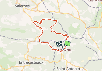
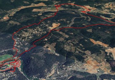
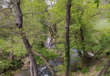
Tocht Stappen van 15,2 km beschikbaar op Provence-Alpes-Côte d'Azur, Var, Saint-Antonin-du-Var. Deze tocht wordt voorgesteld door jean-marie.parachini.
Beschrijving
De Mentone à Salernes à travers les paysages des vignobles vues vers les villages de Villecroze et Tourtour d'un coté et le Grand Bessillon de l'autre.
Retour par l'ancien sentier du train des pignes.
Plaatsbepaling
Land:
France
Regio :
Provence-Alpes-Côte d'Azur
Departement/Provincie :
Var
Gemeente :
Saint-Antonin-du-Var
Locatie:
Unknown
Vertrek:(Dec)
Vertrek:(UTM)
280416 ; 4822741 (32T) N.
Opmerkingen
Wandeltochten in de omgeving
![Tocht Andere activiteiten Villecroze - fox - Photo](https://media.geolcdn.com/t/375/260/ext.jpg?maxdim=2&url=https%3A%2F%2Fstatic1.geolcdn.com%2Fsiteimages%2Fupload%2Ffiles%2F1545311037marcheuse_200dpi.jpg)
![Andere activiteiten Andere activiteiten](https://static1.geolcdn.com/sitytour/trail-icons/900.png)
fox
Andere activiteiten
Medium
(1)
Villecroze,
Provence-Alpes-Côte d'Azur,
Var,
France
![](/images/other/stat-length.png)
42 km | 52 km-effort
2h 24min
![](https://static1.geolcdn.com/siteimages/upload/files/16400158638029165_repeat_loop_refresh_sync_direction_icon.png)
Ja
![Tocht Mountainbike Villecroze - st bart - Photo](https://media.geolcdn.com/t/375/260/ext.jpg?maxdim=2&url=https%3A%2F%2Fstatic1.geolcdn.com%2Fsiteimages%2Fupload%2Ffiles%2F1524743154velo.jpg)
![Mountainbike Mountainbike](https://static1.geolcdn.com/sitytour/trail-icons/202.png)
st bart
Mountainbike
Moeilijk
(1)
Villecroze,
Provence-Alpes-Côte d'Azur,
Var,
France
![](/images/other/stat-length.png)
33 km | 42 km-effort
2h 20min
![](https://static1.geolcdn.com/siteimages/upload/files/16400158638029165_repeat_loop_refresh_sync_direction_icon.png)
Ja
![Tocht Mountainbike Villecroze - giant vs haibike - Photo](https://media.geolcdn.com/t/375/260/ext.jpg?maxdim=2&url=https%3A%2F%2Fstatic1.geolcdn.com%2Fsiteimages%2Fupload%2Ffiles%2F1524743154velo.jpg)
![Mountainbike Mountainbike](https://static1.geolcdn.com/sitytour/trail-icons/202.png)
giant vs haibike
Mountainbike
Medium
(1)
Villecroze,
Provence-Alpes-Côte d'Azur,
Var,
France
![](/images/other/stat-length.png)
29 km | 36 km-effort
1h 49min
![](https://static1.geolcdn.com/siteimages/upload/files/16400158638029165_repeat_loop_refresh_sync_direction_icon.png)
Ja
![Tocht Stappen Villecroze - Villecroze- Domaine Saint Jean - Photo](https://media.geolcdn.com/t/375/260/1159e4c7-252a-4789-9dc1-6697f859dafa.jpg&format=jpg&maxdim=2)
![Stappen Stappen](https://static1.geolcdn.com/sitytour/trail-icons/101.png)
Villecroze- Domaine Saint Jean
Stappen
Gemakkelijk
Villecroze,
Provence-Alpes-Côte d'Azur,
Var,
France
![](/images/other/stat-length.png)
4,3 km | 5,4 km-effort
1h 16min
![](https://static1.geolcdn.com/siteimages/upload/files/16400158638029165_repeat_loop_refresh_sync_direction_icon.png)
Neen
![Tocht sport Salernes - 2024-09-10_08h30m19_rando salernes P.Baille - Photo](https://media.geolcdn.com/t/375/260/ext.jpg?maxdim=2&url=https%3A%2F%2Fsecurestorage.geolives.com%2Fsitytour%2Ftrail-bg%2Fdefault.jpg)
2024-09-10_08h30m19_rando salernes P.Baille
sport
Heel gemakkelijk
(1)
Salernes,
Provence-Alpes-Côte d'Azur,
Var,
France
![](/images/other/stat-length.png)
36 km | 48 km-effort
Onbekend
![](https://static1.geolcdn.com/siteimages/upload/files/16400158638029165_repeat_loop_refresh_sync_direction_icon.png)
Ja
![Tocht sport Saint-Antonin-du-Var - 2024-02-05_17h29m21_st antonin demain - Photo](https://media.geolcdn.com/t/375/260/ext.jpg?maxdim=2&url=https%3A%2F%2Fsecurestorage.geolives.com%2Fsitytour%2Ftrail-bg%2Fdefault.jpg)
2024-02-05_17h29m21_st antonin demain
sport
Heel gemakkelijk
(1)
Saint-Antonin-du-Var,
Provence-Alpes-Côte d'Azur,
Var,
France
![](/images/other/stat-length.png)
27 km | 35 km-effort
Onbekend
![](https://static1.geolcdn.com/siteimages/upload/files/16400158638029165_repeat_loop_refresh_sync_direction_icon.png)
Ja
![Tocht Stappen Entrecasteaux - 2023-11-28 Encastreaux Mentone - Photo](https://media.geolcdn.com/t/375/260/55d6a213-bd6e-43cc-a50c-f4aedf4623ce.jpg&format=jpg&maxdim=2)
![Stappen Stappen](https://static1.geolcdn.com/sitytour/trail-icons/101.png)
2023-11-28 Encastreaux Mentone
Stappen
Medium
Entrecasteaux,
Provence-Alpes-Côte d'Azur,
Var,
France
![](/images/other/stat-length.png)
15,5 km | 22 km-effort
4h 54min
![](https://static1.geolcdn.com/siteimages/upload/files/16400158638029165_repeat_loop_refresh_sync_direction_icon.png)
Ja
![Tocht Stappen Entrecasteaux - 2023-03-03 16-16-56 - Photo](https://media.geolcdn.com/t/375/260/e3754524-1b1b-4fbb-8572-3a4b34c7ddfe.jpg&format=jpg&maxdim=2)
![Stappen Stappen](https://static1.geolcdn.com/sitytour/trail-icons/101.png)
2023-03-03 16-16-56
Stappen
Gemakkelijk
Entrecasteaux,
Provence-Alpes-Côte d'Azur,
Var,
France
![](/images/other/stat-length.png)
16,1 km | 23 km-effort
6h 0min
![](https://static1.geolcdn.com/siteimages/upload/files/16400158638029165_repeat_loop_refresh_sync_direction_icon.png)
Ja
![Tocht Stappen Entrecasteaux - entrecastaux / mentonne - Photo](https://media.geolcdn.com/t/375/260/43adbfcf-5c5e-44a6-81ff-e17e6520c91e.jpg&format=jpg&maxdim=2)
![Stappen Stappen](https://static1.geolcdn.com/sitytour/trail-icons/101.png)
entrecastaux / mentonne
Stappen
Gemakkelijk
Entrecasteaux,
Provence-Alpes-Côte d'Azur,
Var,
France
![](/images/other/stat-length.png)
14,3 km | 19,6 km-effort
3h 42min
![](https://static1.geolcdn.com/siteimages/upload/files/16400158638029165_repeat_loop_refresh_sync_direction_icon.png)
Ja