![](/images/other/stat-length.png)
![Tocht Stappen Turckheim - SityTrail - Turckheim-Trois Epis - Photo](https://media.geolcdn.com/t/1900/400/ext.pjpeg?maxdim=2&url=https%3A%2F%2Fstatic1.geolcdn.com%2Fsiteimages%2Fupload%2Ffiles%2F1553511878bg_sport_marche.png)
SityTrail - Turckheim-Trois Epis
Seppala - Balades du jeudi
Jetz geht's wieder los, noch dem bloede COVID19
![Lengte](/images/other/stat-length.png)
![Max. hoogte](https://static1.geolcdn.com/siteimages/upload/files/1508320355ic_sort_altitude_max_24dp.png)
![Positief hoogteverschil](https://static1.geolcdn.com/siteimages/upload/files/1508320355ic_sort_den_pos_24dp.png)
![Km-Effort](/images/other/stat-length.png)
![Min. hoogte](https://static1.geolcdn.com/siteimages/upload/files/1508320355ic_sort_altitude_min_24dp.png)
![Negatief hoogteverschil](https://static1.geolcdn.com/siteimages/upload/files/1508320355ic_sort_den_neg_24dp.png)
![Boucle](https://static1.geolcdn.com/siteimages/upload/files/16400158638029165_repeat_loop_refresh_sync_direction_icon.png)
![Stappen](https://static1.geolcdn.com/sitytour/trail-icons/101.png)
3h45
Moeilijkheid : Medium
![Scan deze QR-code om de tocht te openen in de SityTrail-applicatie](https://capi.geolives.com/qq0zvz2zws4bq2lad0pu/sitytour/trails/2583775/qr.png?size=200)
Gratisgps-wandelapplicatie
Over ons
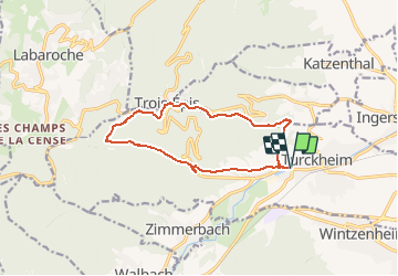
Tocht Stappen van 11,7 km beschikbaar op Grand Est, Haut-Rhin, Turckheim. Deze tocht wordt voorgesteld door Seppala - Balades du jeudi.
Beschrijving
Partir de Turckheim pour aller aux Trois Epis.
Dénivelé de 500 m (le matin) et 11.5 km au total.
ACCÈS :
- Turckheim, rue des Tuileries après le Monument Turenne
PARKING :
- Le long de la rue des Tuileries après le Monument Turenne
48.086019, 7.269141 ou
N 48°05'10", E 07°16'09"
RESTAURATION :
Restaurant "Le Turckheim Croix d'Or" aux Trois Epis
Tél.: 03 89 49 83 55
Plaatsbepaling
Opmerkingen
Wandeltochten in de omgeving
![Tocht Stappen Wettolsheim - 4 châteaux Wettolsheim Husseren - Photo](https://media.geolcdn.com/t/375/260/3d38d7b6-fe96-472e-849b-8dfa9ade163e.jpg&format=jpg&maxdim=2)
![Stappen Stappen](https://static1.geolcdn.com/sitytour/trail-icons/101.png)
Stappen
![](/images/other/stat-length.png)
![](https://static1.geolcdn.com/siteimages/upload/files/16400158638029165_repeat_loop_refresh_sync_direction_icon.png)
![Tocht Stappen Ammerschwihr - D'Ammerschwihr aux Trois Epis - Photo](https://media.geolcdn.com/t/375/260/ext.jpg?maxdim=2&url=https%3A%2F%2Fservices.sitytrail.com%2FGeolivesWS%2FDownloadMedia.ashx%3FTrailID%3D404804%26Media%3Dfix__20150406154748.jpg)
![Stappen Stappen](https://static1.geolcdn.com/sitytour/trail-icons/101.png)
Stappen
![](/images/other/stat-length.png)
![](https://static1.geolcdn.com/siteimages/upload/files/16400158638029165_repeat_loop_refresh_sync_direction_icon.png)
![Tocht Stappen Ammerschwihr - Trois Épis le rocher du corbeau - Photo](https://media.geolcdn.com/t/375/260/dbdb5766-f574-4a80-9cd8-371c84f0061c.jpg&format=jpg&maxdim=2)
![Stappen Stappen](https://static1.geolcdn.com/sitytour/trail-icons/101.png)
Stappen
![](/images/other/stat-length.png)
![](https://static1.geolcdn.com/siteimages/upload/files/16400158638029165_repeat_loop_refresh_sync_direction_icon.png)
![Tocht Stappen Eguisheim - suuntoapp-Hiking-2023-12-29T09-05-16Z - Photo](https://media.geolcdn.com/t/375/260/dcbc603a-6326-4148-957e-2ff1d984719d.jpg&format=jpg&maxdim=2)
![Stappen Stappen](https://static1.geolcdn.com/sitytour/trail-icons/101.png)
Stappen
![](/images/other/stat-length.png)
![](https://static1.geolcdn.com/siteimages/upload/files/16400158638029165_repeat_loop_refresh_sync_direction_icon.png)
![Tocht Stappen Wintzenheim - Boucle de la fontaine de la dame - Photo](https://media.geolcdn.com/t/375/260/ee79f3ee-48dc-4e78-8e39-2ea9fd8c2e7b.jpg&format=jpg&maxdim=2)
![Stappen Stappen](https://static1.geolcdn.com/sitytour/trail-icons/101.png)
Stappen
![](/images/other/stat-length.png)
![](https://static1.geolcdn.com/siteimages/upload/files/16400158638029165_repeat_loop_refresh_sync_direction_icon.png)
![Tocht Mountainbike Wintzenheim - Wintzenheim - Le Stauffen - Col de Marbach - Soultzbach - Photo](https://media.geolcdn.com/t/375/260/ext.jpg?maxdim=2&url=https%3A%2F%2Fstatic1.geolcdn.com%2Fsiteimages%2Fupload%2Ffiles%2F1524743154velo.jpg)
![Mountainbike Mountainbike](https://static1.geolcdn.com/sitytour/trail-icons/202.png)
Mountainbike
![](/images/other/stat-length.png)
![](https://static1.geolcdn.com/siteimages/upload/files/16400158638029165_repeat_loop_refresh_sync_direction_icon.png)
![Tocht Stappen Wintzenheim - Château de Pflixbourg depuis Saint Gilles - Photo](https://media.geolcdn.com/t/375/260/ext.jpg?maxdim=2&url=https%3A%2F%2Fstatic1.geolcdn.com%2Fsiteimages%2Fupload%2Ffiles%2F1553511878bg_sport_marche.png)
![Stappen Stappen](https://static1.geolcdn.com/sitytour/trail-icons/101.png)
Stappen
![](/images/other/stat-length.png)
![](https://static1.geolcdn.com/siteimages/upload/files/16400158638029165_repeat_loop_refresh_sync_direction_icon.png)
![Tocht Stappen Zimmerbach - Rando](https://media.geolcdn.com/t/375/260/1e5817ff-63e6-4c21-8b39-93a77134a573.jpg&format=jpg&maxdim=2)
![Stappen Stappen](https://static1.geolcdn.com/sitytour/trail-icons/101.png)
Stappen
![](/images/other/stat-length.png)
![](https://static1.geolcdn.com/siteimages/upload/files/16400158638029165_repeat_loop_refresh_sync_direction_icon.png)
![Tocht Stappen Eguisheim - eguishem- vignoble et château - Photo](https://media.geolcdn.com/t/375/260/716e53f7-6c62-4632-b95d-d4dde92fd7e4.jpg&format=jpg&maxdim=2)
![Stappen Stappen](https://static1.geolcdn.com/sitytour/trail-icons/101.png)
Stappen
![](/images/other/stat-length.png)
![](https://static1.geolcdn.com/siteimages/upload/files/16400158638029165_repeat_loop_refresh_sync_direction_icon.png)