Tocht Mountainbike Ogeu-les-Bains - Ogeu  - Randonnée sportive de la vallée de l'Escou  - 44 Km - Photo

Ogeu - Randonnée sportive de la vallée de l'Escou - 44 Km

 potofe
potofe

Gebruiker

© OpenStreetMap contributors
Lengte
Lengte
44 km
Max. hoogte
Max. hoogte
427 m
Positief hoogteverschil
703 m
Km-Effort
Km-Effort  
53 km
Min. hoogte
Min. hoogte
214 m
Negatief hoogteverschil
703 m
Boucle
Boucle
Ja
Datum van aanmaak :
2020-10-18 11:56:48.0
Laatste wijziging :
2020-10-21 19:54:16.403

(0 Bericht)

Mountainbike
Mountainbike
3h17
Moeilijkheid : Moeilijk

Scan deze QR-code om de tocht te openen in de SityTrail-applicatie

Gratisgps-wandelapplicatie

Logo SityTrail SityTrail

IGN / Geografische instituten

SityTrail uit de App Store downloaden SityTrail uit Google Play downloaden

Logo SityTrail SityTrail World

De wereld gaat voor u open

SityTrail uit de App Store downloaden SityTrail uit Google Play downloaden SityTrail op Huawei AppGallery downloaden

Over ons

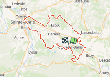
Tocht Mountainbike van 44 km beschikbaar op Nieuw-Aquitanië, Pyrénées-Atlantiques, Ogeu-les-Bains. Deze tocht wordt voorgesteld door potofe.

Beschrijving

Circuit balisé N°14.
25 premier km plutôt VTC, 15 dernier km vraiment VTT avec des parties technique au bord du gave.
1 petit gué.
18/10/2020

Hoogteprofiel

Plaatsbepaling

Land:
France
Regio :
Nieuw-Aquitanië
Departement/Provincie :
Pyrénées-Atlantiques
Gemeente :
Ogeu-les-Bains
Locatie:
Unknown
Vertrek:(Dec)
Vertrek:(UTM)
702838 ; 4780089 (30T) N.

Wandeltochten in de omgeving

Tocht Te voet Buzy - Les chênes - Photo
Te voet
PRO

Te voet

Gemakkelijk
Buzy, Nieuw-Aquitanië, Pyrénées-Atlantiques, France
4 km | 5,1 km-effort
1h 9min
Ja
Tocht Te voet Buzy - Tour du dolmen - Photo
Te voet
PRO

Te voet

Gemakkelijk
Buzy, Nieuw-Aquitanië, Pyrénées-Atlantiques, France
9,4 km | 11,6 km-effort
2h 38min
Ja
Tocht Stappen Ogeu-les-Bains - Gr78 fait  - Photo
Stappen
LouisROGER

Stappen

Zeer moeilijk
Ogeu-les-Bains, Nieuw-Aquitanië, Pyrénées-Atlantiques, France
15,9 km | 22 km-effort
4h 55min
Neen
Tocht Stappen Escout - Pont du Diable - Photo
Stappen
HaschKnight

Stappen

Gemakkelijk
Escout, Nieuw-Aquitanië, Pyrénées-Atlantiques, France
5,6 km | 6,6 km-effort
57min
Ja
Tocht Stappen Buzy - Chemin du Piémont Pyrénéen - De Buzy à Oloron Sainte Marie - Photo
Stappen
tracegps

Stappen

Moeilijk
Buzy, Nieuw-Aquitanië, Pyrénées-Atlantiques, France
18,7 km | 22 km-effort
4h 40min
Neen
Tocht Stappen Buzy - Buzy-Oloron ste marie  - Photo
Stappen
dagobert5612

Stappen

Gemakkelijk
Buzy, Nieuw-Aquitanië, Pyrénées-Atlantiques, France
21 km | 25 km-effort
6h 38min
Neen
Tocht Te voet Buzy - GR78 (Mon GR préféré) BUZY / OLORON gare  19 km 219M+
Te voet
GUIDE
marmotte65

Te voet

Medium
Buzy, Nieuw-Aquitanië, Pyrénées-Atlantiques, France
19,2 km | 23 km-effort
5h 8min
Neen
Tocht Te voet Buzy - GR78 Variante d'Arudy - Photo
Te voet
PRO

Te voet

Gemakkelijk
Buzy, Nieuw-Aquitanië, Pyrénées-Atlantiques, France
3,7 km | 4,6 km-effort
1h 2min
Neen
Tocht Stappen Oloron-Sainte-Marie - Fôret du Bager - Photo
Stappen
HaschKnight

Stappen

Medium
Oloron-Sainte-Marie, Nieuw-Aquitanië, Pyrénées-Atlantiques, France
4,4 km | 6,2 km-effort
1h 31min
Ja


Sluiten
Mijn abonnementen