![](/images/other/stat-length.png)
![Tocht Te voet Aiguilles - Alpes jour 11: Aiguilles à Ceillac - Photo](https://media.geolcdn.com/t/1900/400/ext.pjpeg?maxdim=2&url=https%3A%2F%2Fstatic1.geolcdn.com%2Fsiteimages%2Fupload%2Ffiles%2F1545311037marcheuse_200dpi.jpg)
Alpes jour 11: Aiguilles à Ceillac
MathieuBourgois
Gebruiker
![Lengte](/images/other/stat-length.png)
Lengte
23 km
![Max. hoogte](https://static1.geolcdn.com/siteimages/upload/files/1508320355ic_sort_altitude_max_24dp.png)
Max. hoogte
2315 m
![Positief hoogteverschil](https://static1.geolcdn.com/siteimages/upload/files/1508320355ic_sort_den_pos_24dp.png)
Positief hoogteverschil
1349 m
![Km-Effort](/images/other/stat-length.png)
Km-Effort
40 km
![Min. hoogte](https://static1.geolcdn.com/siteimages/upload/files/1508320355ic_sort_altitude_min_24dp.png)
Min. hoogte
1346 m
![Negatief hoogteverschil](https://static1.geolcdn.com/siteimages/upload/files/1508320355ic_sort_den_neg_24dp.png)
Negatief hoogteverschil
1173 m
![Boucle](https://static1.geolcdn.com/siteimages/upload/files/16400158638029165_repeat_loop_refresh_sync_direction_icon.png)
Boucle
Neen
Datum van aanmaak :
2020-10-16 12:01:29.601
Laatste wijziging :
2021-06-01 12:41:52.327
![Te voet](https://static1.geolcdn.com/sitytour/trail-icons/100.png)
--
Moeilijkheid : Medium
![Scan deze QR-code om de tocht te openen in de SityTrail-applicatie](https://capi.geolives.com/qq0zvz2zws4bq2lad0pu/sitytour/trails/2578778/qr.png?size=200)
Gratisgps-wandelapplicatie
Over ons
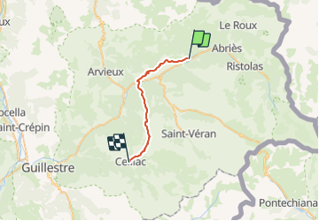
Tocht Te voet van 23 km beschikbaar op Provence-Alpes-Côte d'Azur, Hautes-Alpes, Aiguilles. Deze tocht wordt voorgesteld door MathieuBourgois.
Beschrijving
Passage du GR(! au GR5
Château Queyras 9.5km et 350D
Col du fromage 18km et 1350D
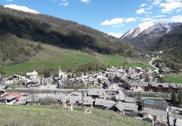
Le Villard 21km et 1350D
Ceillac 23km et 1350D
Plaatsbepaling
Land:
France
Regio :
Provence-Alpes-Côte d'Azur
Departement/Provincie :
Hautes-Alpes
Gemeente :
Aiguilles
Locatie:
Unknown
Vertrek:(Dec)
Vertrek:(UTM)
331473 ; 4960852 (32T) N.
Opmerkingen
Wandeltochten in de omgeving
![Tocht Stappen Château-Ville-Vieille - Queyras j1 - Photo](https://media.geolcdn.com/t/375/260/ext.jpg?maxdim=2&url=https%3A%2F%2Fmedia.geolcdn.com%2Ff%2F78b4351d-2aa3-4d9e-84af-a2a8af3e275c.jpg)
![Stappen Stappen](https://static1.geolcdn.com/sitytour/trail-icons/101.png)
Queyras j1
Stappen
Medium
(1)
Château-Ville-Vieille,
Provence-Alpes-Côte d'Azur,
Hautes-Alpes,
France
![](/images/other/stat-length.png)
19,1 km | 36 km-effort
8h 6min
![](https://static1.geolcdn.com/siteimages/upload/files/16400158638029165_repeat_loop_refresh_sync_direction_icon.png)
Neen
![Tocht Stappen Château-Ville-Vieille - Ville-vieille - Ceillac - Photo](https://media.geolcdn.com/t/375/260/ext.jpg?maxdim=2&url=https%3A%2F%2Fservices.sitytrail.com%2FGeolivesWS%2FDownloadMedia.ashx%3FTrailID%3D629864%26Media%3Dfix__20160909131710.jpg)
![Stappen Stappen](https://static1.geolcdn.com/sitytour/trail-icons/101.png)
Ville-vieille - Ceillac
Stappen
Medium
Château-Ville-Vieille,
Provence-Alpes-Côte d'Azur,
Hautes-Alpes,
France
![](/images/other/stat-length.png)
17,4 km | 31 km-effort
6h 51min
![](https://static1.geolcdn.com/siteimages/upload/files/16400158638029165_repeat_loop_refresh_sync_direction_icon.png)
Neen
![Tocht Stappen Abriès-Ristolas - Abriès - Aiguilles - Photo](https://media.geolcdn.com/t/375/260/ext.jpg?maxdim=2&url=https%3A%2F%2Fservices.sitytrail.com%2FGeolivesWS%2FDownloadMedia.ashx%3FTrailID%3D629859%26Media%3Dfix__20160907131116.jpg)
![Stappen Stappen](https://static1.geolcdn.com/sitytour/trail-icons/101.png)
Abriès - Aiguilles
Stappen
Moeilijk
Abriès-Ristolas,
Provence-Alpes-Côte d'Azur,
Hautes-Alpes,
France
![](/images/other/stat-length.png)
16,9 km | 32 km-effort
7h 19min
![](https://static1.geolcdn.com/siteimages/upload/files/16400158638029165_repeat_loop_refresh_sync_direction_icon.png)
Neen
![Tocht Stappen Abriès-Ristolas - Abriès - Aiguilles - Photo](https://media.geolcdn.com/t/375/260/ext.jpg?maxdim=2&url=https%3A%2F%2Fservices.sitytrail.com%2FGeolivesWS%2FDownloadMedia.ashx%3FTrailID%3D629858%26Media%3Dfix__20160907131116.jpg)
![Stappen Stappen](https://static1.geolcdn.com/sitytour/trail-icons/101.png)
Abriès - Aiguilles
Stappen
Moeilijk
Abriès-Ristolas,
Provence-Alpes-Côte d'Azur,
Hautes-Alpes,
France
![](/images/other/stat-length.png)
16,9 km | 32 km-effort
7h 19min
![](https://static1.geolcdn.com/siteimages/upload/files/16400158638029165_repeat_loop_refresh_sync_direction_icon.png)
Neen
![Tocht Stappen Aiguilles - les lacs du Malrifs - Photo](https://media.geolcdn.com/t/375/260/ext.jpg?maxdim=2&url=https%3A%2F%2Fservices.sitytrail.com%2FGeolivesWS%2FDownloadMedia.ashx%3FTrailID%3D445852%26Media%3Dfix__20150715135638.jpg)
![Stappen Stappen](https://static1.geolcdn.com/sitytour/trail-icons/101.png)
les lacs du Malrifs
Stappen
Heel gemakkelijk
Aiguilles,
Provence-Alpes-Côte d'Azur,
Hautes-Alpes,
France
![](/images/other/stat-length.png)
11 km | 21 km-effort
4h 44min
![](https://static1.geolcdn.com/siteimages/upload/files/16400158638029165_repeat_loop_refresh_sync_direction_icon.png)
Ja
![Tocht Stappen Abriès-Ristolas - Malrif à partir de Abries - Photo](https://media.geolcdn.com/t/375/260/ext.jpg?maxdim=2&url=https%3A%2F%2Fmedia.geolcdn.com%2Ff%2F2962a407-1b8d-4c1a-aa47-69b94a8a67a9.jpg)
![Stappen Stappen](https://static1.geolcdn.com/sitytour/trail-icons/101.png)
Malrif à partir de Abries
Stappen
Medium
Abriès-Ristolas,
Provence-Alpes-Côte d'Azur,
Hautes-Alpes,
France
![](/images/other/stat-length.png)
9,8 km | 17,1 km-effort
3h 36min
![](https://static1.geolcdn.com/siteimages/upload/files/16400158638029165_repeat_loop_refresh_sync_direction_icon.png)
Ja
![Tocht Stappen Aiguilles - lacs malrif à partir du lombard - Photo](https://media.geolcdn.com/t/375/260/ext.jpg?maxdim=2&url=https%3A%2F%2Fmedia.geolcdn.com%2Ff%2Fd26d85f3-06e6-47dd-a3a6-5aa27f5ad3eb.jpg)
![Stappen Stappen](https://static1.geolcdn.com/sitytour/trail-icons/101.png)
lacs malrif à partir du lombard
Stappen
Medium
Aiguilles,
Provence-Alpes-Côte d'Azur,
Hautes-Alpes,
France
![](/images/other/stat-length.png)
9,8 km | 19,4 km-effort
3h 45min
![](https://static1.geolcdn.com/siteimages/upload/files/16400158638029165_repeat_loop_refresh_sync_direction_icon.png)
Ja
![Tocht Stappen Abriès-Ristolas - J7 Queyras 2022 - Photo](https://media.geolcdn.com/t/375/260/ext.jpg?maxdim=2&url=https%3A%2F%2Fmedia.geolcdn.com%2Ff%2F450bc122-3ea0-41ea-b5c8-ff1bf4ba33e6.jpg)
![Stappen Stappen](https://static1.geolcdn.com/sitytour/trail-icons/101.png)
J7 Queyras 2022
Stappen
Zeer moeilijk
Abriès-Ristolas,
Provence-Alpes-Côte d'Azur,
Hautes-Alpes,
France
![](/images/other/stat-length.png)
19,6 km | 38 km-effort
5h 31min
![](https://static1.geolcdn.com/siteimages/upload/files/16400158638029165_repeat_loop_refresh_sync_direction_icon.png)
Ja
![Tocht Stappen Château-Ville-Vieille - 05-pointe-du-Rasis-13km-760m-aout21 - Photo](https://media.geolcdn.com/t/375/260/ext.jpg?maxdim=2&url=https%3A%2F%2Fmedia.geolcdn.com%2Ff%2Fab196ec4-46c6-451a-a3c4-d57666189769.jpg)
![Stappen Stappen](https://static1.geolcdn.com/sitytour/trail-icons/101.png)
05-pointe-du-Rasis-13km-760m-aout21
Stappen
Moeilijk
Château-Ville-Vieille,
Provence-Alpes-Côte d'Azur,
Hautes-Alpes,
France
![](/images/other/stat-length.png)
13,2 km | 23 km-effort
5h 32min
![](https://static1.geolcdn.com/siteimages/upload/files/16400158638029165_repeat_loop_refresh_sync_direction_icon.png)
Ja