Tocht Stappen Le Boulou - casino du Boulou, pic estelle  - Photo

casino du Boulou, pic estelle

 Denis Delay
Denis Delay

Gebruiker

© OpenStreetMap contributors
Lengte
Lengte
6,7 km
Max. hoogte
Max. hoogte
369 m
Positief hoogteverschil
283 m
Km-Effort
Km-Effort  
10,4 km
Min. hoogte
Min. hoogte
94 m
Negatief hoogteverschil
283 m
Boucle
Boucle
Ja
Datum van aanmaak :
2020-10-15 11:21:10.228
Laatste wijziging :
2020-10-15 13:49:44.677

(0 Bericht)

Stappen
Stappen
2h27
Moeilijkheid : Gemakkelijk

Scan deze QR-code om de tocht te openen in de SityTrail-applicatie

Gratisgps-wandelapplicatie

Logo SityTrail SityTrail

IGN / Geografische instituten

SityTrail uit de App Store downloaden SityTrail uit Google Play downloaden

Logo SityTrail SityTrail World

De wereld gaat voor u open

SityTrail uit de App Store downloaden SityTrail uit Google Play downloaden SityTrail op Huawei AppGallery downloaden

Over ons

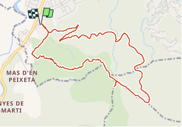
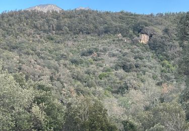
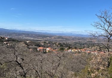
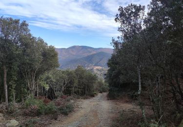
Tocht Stappen van 6,7 km beschikbaar op Occitanië, Pyrénées-Orientales, Le Boulou. Deze tocht wordt voorgesteld door Denis Delay.

Beschrijving

forte pente à la montée, piste à la descente.

Hoogteprofiel

Plaatsbepaling

Land:
France
Regio :
Occitanië
Departement/Provincie :
Pyrénées-Orientales
Gemeente :
Le Boulou
Locatie:
Unknown
Vertrek:(UTM)
486067 ; 4706669 (31T) N.

Wandeltochten in de omgeving

Tocht Stappen Les Cluses - LES CLUSES 66 - Photo
Stappen
jeff66

Stappen

Gemakkelijk
(9)
Les Cluses, Occitanië, Pyrénées-Orientales, France
9,4 km | 12,8 km-effort
1h 50min
Ja
Tocht Stappen Saint-Jean-Pla-de-Corts - 66 ST-JEAN-PLA-DE-CORTS, promenade autour du Tech, jusqu'au BOULOU  - Photo
Stappen
jeff66

Stappen

Gemakkelijk
(1)
Saint-Jean-Pla-de-Corts, Occitanië, Pyrénées-Orientales, France
7,9 km | 8,8 km-effort
1h 18min
Ja
Tocht Stappen Maureillas-las-Illas - CERET 66 - les hauts de CERET - ballade en bas Vallespir - dolmen de la Siureda torre Bel Ull  - Photo
Stappen
jeff66

Stappen

Medium
(1)
Maureillas-las-Illas, Occitanië, Pyrénées-Orientales, France
6,5 km | 9,9 km-effort
1h 24min
Ja
Tocht Stappen Montesquieu-des-Albères - MONTESQUIEU-DES-ALBERES 66 - Les Agouillous - les chemins de l'eau dans les Albères - Photo
Stappen
jeff66

Stappen

Medium
(1)
Montesquieu-des-Albères, Occitanië, Pyrénées-Orientales, France
12,7 km | 13,9 km-effort
2h 16min
Ja
Tocht Stappen Le Boulou - LES THERMES DU BOULOU - 66 - Albera viva - PUIG de l'Estella - Photo
Stappen
jeff66

Stappen

Medium
(2)
Le Boulou, Occitanië, Pyrénées-Orientales, France
7,3 km | 11,4 km-effort
1h 32min
Ja
Tocht Stappen Les Cluses - LES CLUSES 66 - LE PERTHUS -  - Photo
Stappen
jeff66

Stappen

Medium
(2)
Les Cluses, Occitanië, Pyrénées-Orientales, France
14,4 km | 20 km-effort
2h 57min
Ja
Tocht Stappen Le Boulou - Le Boulou, chapelle saint Phillipe, mas d'en Conte - Photo
Stappen
nandaf

Stappen

Medium
(1)
Le Boulou, Occitanië, Pyrénées-Orientales, France
5,2 km | 7,6 km-effort
1h 43min
Ja
Tocht Stappen Montesquieu-des-Albères - Montesquieu des Albères - Photo
Stappen
nandaf

Stappen

Medium
(1)
Montesquieu-des-Albères, Occitanië, Pyrénées-Orientales, France
7,4 km | 10,9 km-effort
2h 27min
Ja
Tocht Stappen Maureillas-las-Illas - RIUNOGUES PORTELL PANISSAR - Photo
Stappen
MarcOBRECHT

Stappen

Medium
(1)
Maureillas-las-Illas, Occitanië, Pyrénées-Orientales, France
18 km | 26 km-effort
4h 35min
Ja


Sluiten
Mijn abonnementen