![](/images/other/stat-length.png)
![Tocht Stappen Anniviers - - Photo](https://media.geolcdn.com/t/1900/400/ext.pjpeg?maxdim=2&url=https%3A%2F%2Fstatic1.geolcdn.com%2Fsiteimages%2Fupload%2Ffiles%2F1553511878bg_sport_marche.png)
lroux
Gebruiker
![Lengte](/images/other/stat-length.png)
![Max. hoogte](https://static1.geolcdn.com/siteimages/upload/files/1508320355ic_sort_altitude_max_24dp.png)
![Positief hoogteverschil](https://static1.geolcdn.com/siteimages/upload/files/1508320355ic_sort_den_pos_24dp.png)
![Km-Effort](/images/other/stat-length.png)
![Min. hoogte](https://static1.geolcdn.com/siteimages/upload/files/1508320355ic_sort_altitude_min_24dp.png)
![Negatief hoogteverschil](https://static1.geolcdn.com/siteimages/upload/files/1508320355ic_sort_den_neg_24dp.png)
![Boucle](https://static1.geolcdn.com/siteimages/upload/files/16400158638029165_repeat_loop_refresh_sync_direction_icon.png)
![Stappen](https://static1.geolcdn.com/sitytour/trail-icons/101.png)
6h18
Moeilijkheid : Onbekend
![Scan deze QR-code om de tocht te openen in de SityTrail-applicatie](https://capi.geolives.com/qq0zvz2zws4bq2lad0pu/sitytour/trails/25708/qr.png?size=200)
Gratisgps-wandelapplicatie
Over ons
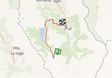
Tocht Stappen van 14,3 km beschikbaar op Valais/Wallis, Sierre, Anniviers. Deze tocht wordt voorgesteld door lroux.
Beschrijving
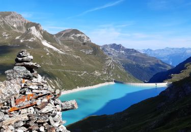
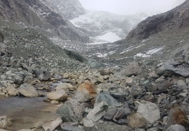
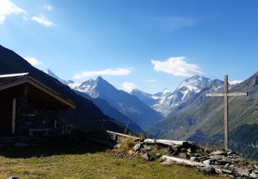
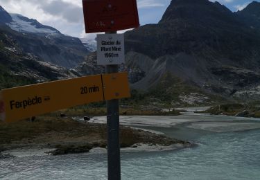
En redescendant de la cabane de Moiry prendre à droite le Haut Chemin, cette fois sur la rive droite du lac. Bien tracé, spectaculaire et très aérien. Avant d''arriver sur la fin, avant le tourniquet qui marque le début des prairies d''alpage, des champs d''edelweiss. Zinal un hotel historique Le Besso (154.-/chambre double). Bonne bouffe assez chère, en revanche.
Plaatsbepaling
Opmerkingen
Wandeltochten in de omgeving
![Tocht Stappen Anniviers - Grimentz, Cabane de Moiry - Photo](https://media.geolcdn.com/t/375/260/ext.jpg?maxdim=2&url=https%3A%2F%2Fstatic1.geolcdn.com%2Fsiteimages%2Fupload%2Ffiles%2F1553511878bg_sport_marche.png)
![Stappen Stappen](https://static1.geolcdn.com/sitytour/trail-icons/101.png)
Stappen
![](/images/other/stat-length.png)
![](https://static1.geolcdn.com/siteimages/upload/files/16400158638029165_repeat_loop_refresh_sync_direction_icon.png)
![Tocht Stappen Anniviers - La Haute Route : J7 - Photo](https://media.geolcdn.com/t/375/260/215b1e41-2c53-4932-8784-e6834704d0a7.jpg&format=jpg&maxdim=2)
![Stappen Stappen](https://static1.geolcdn.com/sitytour/trail-icons/101.png)
Stappen
![](/images/other/stat-length.png)
![](https://static1.geolcdn.com/siteimages/upload/files/16400158638029165_repeat_loop_refresh_sync_direction_icon.png)
![Tocht Stappen Evolène - glacier mont miné - Photo](https://media.geolcdn.com/t/375/260/849256b3-79a0-4e3d-a14f-3b9ab44c6963.jpg&format=jpg&maxdim=2)
![Stappen Stappen](https://static1.geolcdn.com/sitytour/trail-icons/101.png)
Stappen
![](/images/other/stat-length.png)
![](https://static1.geolcdn.com/siteimages/upload/files/16400158638029165_repeat_loop_refresh_sync_direction_icon.png)
![Tocht Stappen Anniviers - zinal mine de zinc - Photo](https://media.geolcdn.com/t/375/260/b9729ac6-eee5-4342-93ad-996125141cdb.jpg&format=jpg&maxdim=2)
![Stappen Stappen](https://static1.geolcdn.com/sitytour/trail-icons/101.png)
Stappen
![](/images/other/stat-length.png)
![](https://static1.geolcdn.com/siteimages/upload/files/16400158638029165_repeat_loop_refresh_sync_direction_icon.png)
![Tocht Stappen Anniviers - La Haute Route : J8 - Photo](https://media.geolcdn.com/t/375/260/5247983f-aa8f-4ee3-aa2c-68b4c5614d1e.jpg&format=jpg&maxdim=2)
![Stappen Stappen](https://static1.geolcdn.com/sitytour/trail-icons/101.png)
Stappen
![](/images/other/stat-length.png)
![](https://static1.geolcdn.com/siteimages/upload/files/16400158638029165_repeat_loop_refresh_sync_direction_icon.png)
![Tocht Noords wandelen Evolène - glacier Miné - Photo](https://media.geolcdn.com/t/375/260/8aaa6fb9-4c35-4013-acf1-a4e5b7d6886c.jpg&format=jpg&maxdim=2)
![Noords wandelen Noords wandelen](https://static1.geolcdn.com/sitytour/trail-icons/102.png)
Noords wandelen
![](/images/other/stat-length.png)
![](https://static1.geolcdn.com/siteimages/upload/files/16400158638029165_repeat_loop_refresh_sync_direction_icon.png)
![Tocht Stappen Evolène - bg_tsate - Photo](https://media.geolcdn.com/t/375/260/ext.jpg?maxdim=2&url=https%3A%2F%2Fstatic1.geolcdn.com%2Fsiteimages%2Fupload%2Ffiles%2F1553511878bg_sport_marche.png)
![Stappen Stappen](https://static1.geolcdn.com/sitytour/trail-icons/101.png)
Stappen
![](/images/other/stat-length.png)
![](https://static1.geolcdn.com/siteimages/upload/files/16400158638029165_repeat_loop_refresh_sync_direction_icon.png)
![Tocht Noords wandelen Anniviers - château du Fosteau - Photo](https://media.geolcdn.com/t/375/260/ext.jpg?maxdim=2&url=https%3A%2F%2Fstatic1.geolcdn.com%2Fsiteimages%2Fupload%2Ffiles%2F1545311037marcheuse_200dpi.jpg)
![Noords wandelen Noords wandelen](https://static1.geolcdn.com/sitytour/trail-icons/102.png)
Noords wandelen
![](/images/other/stat-length.png)
![](https://static1.geolcdn.com/siteimages/upload/files/16400158638029165_repeat_loop_refresh_sync_direction_icon.png)
![Tocht Stappen Anniviers - Zinal - point de vue du Chiesso 01.07.16 - Photo](https://media.geolcdn.com/t/375/260/ext.jpg?maxdim=2&url=https%3A%2F%2Fservices.sitytrail.com%2FGeolivesWS%2FDownloadMedia.ashx%3FTrailID%3D591671%26Media%3Df9245dda-ba88-4021-9373-165dd2aba08e.jpg)
![Stappen Stappen](https://static1.geolcdn.com/sitytour/trail-icons/101.png)
Stappen
![](/images/other/stat-length.png)
![](https://static1.geolcdn.com/siteimages/upload/files/16400158638029165_repeat_loop_refresh_sync_direction_icon.png)