![](/images/other/stat-length.png)
![Tocht Te voet Le Bô - le Bo - Photo](https://media.geolcdn.com/t/1900/400/ext.pjpeg?maxdim=2&url=https%3A%2F%2Fstatic1.geolcdn.com%2Fsiteimages%2Fupload%2Ffiles%2F1545311037marcheuse_200dpi.jpg)
le Bo
AACLARANDO
ensemble sur les chemins
![Lengte](/images/other/stat-length.png)
Lengte
7,5 km
![Max. hoogte](https://static1.geolcdn.com/siteimages/upload/files/1508320355ic_sort_altitude_max_24dp.png)
Max. hoogte
214 m
![Positief hoogteverschil](https://static1.geolcdn.com/siteimages/upload/files/1508320355ic_sort_den_pos_24dp.png)
Positief hoogteverschil
195 m
![Km-Effort](/images/other/stat-length.png)
Km-Effort
10,1 km
![Min. hoogte](https://static1.geolcdn.com/siteimages/upload/files/1508320355ic_sort_altitude_min_24dp.png)
Min. hoogte
43 m
![Negatief hoogteverschil](https://static1.geolcdn.com/siteimages/upload/files/1508320355ic_sort_den_neg_24dp.png)
Negatief hoogteverschil
194 m
![Boucle](https://static1.geolcdn.com/siteimages/upload/files/16400158638029165_repeat_loop_refresh_sync_direction_icon.png)
Boucle
Ja
Datum van aanmaak :
2020-10-04 09:39:26.545
Laatste wijziging :
2020-10-06 17:17:42.383
![Te voet](https://static1.geolcdn.com/sitytour/trail-icons/100.png)
--
Moeilijkheid : Medium
![Scan deze QR-code om de tocht te openen in de SityTrail-applicatie](https://capi.geolives.com/qq0zvz2zws4bq2lad0pu/sitytour/trails/2568146/qr.png?size=200)
Gratisgps-wandelapplicatie
Over ons
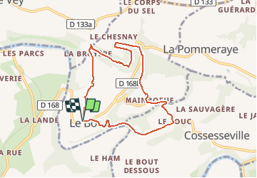
Tocht Te voet van 7,5 km beschikbaar op Normandië, Calvados, Le Bô. Deze tocht wordt voorgesteld door AACLARANDO.
Beschrijving
randonnée sur petits sentiers dans foret, avec très peu de route.
Plaatsbepaling
Land:
France
Regio :
Normandië
Departement/Provincie :
Calvados
Gemeente :
Le Bô
Locatie:
Unknown
Vertrek:(Dec)
Vertrek:(UTM)
686686 ; 5419212 (30U) N.
Opmerkingen
Wandeltochten in de omgeving
![Tocht Mountainbike Pont-d'Ouilly - La Petite Suisse Normande 2014 - Pont-d'Ouilly - Photo](https://media.geolcdn.com/t/375/260/ext.jpg?maxdim=2&url=https%3A%2F%2Fservices.sitytrail.com%2FGeolivesWS%2FDownloadMedia.ashx%3FTrailID%3D317875%26Media%3D17266_3.jpg)
![Mountainbike Mountainbike](https://static1.geolcdn.com/sitytour/trail-icons/202.png)
La Petite Suisse Normande 2014 - Pont-d'Ouilly
Mountainbike
Moeilijk
(1)
Pont-d'Ouilly,
Normandië,
Calvados,
France
![](/images/other/stat-length.png)
41 km | 54 km-effort
3h 30min
![](https://static1.geolcdn.com/siteimages/upload/files/16400158638029165_repeat_loop_refresh_sync_direction_icon.png)
Ja
![Tocht Mountainbike Saint-Omer - Espace VTT FFC de Suisse Normande - Circuit 11 - Saint Omer - Photo](https://media.geolcdn.com/t/375/260/ext.jpg?maxdim=2&url=https%3A%2F%2Fservices.sitytrail.com%2FGeolivesWS%2FDownloadMedia.ashx%3FTrailID%3D106820%26Media%3D11522_1.jpg)
![Mountainbike Mountainbike](https://static1.geolcdn.com/sitytour/trail-icons/202.png)
Espace VTT FFC de Suisse Normande - Circuit 11 - Saint Omer
Mountainbike
Zeer moeilijk
(1)
Saint-Omer,
Normandië,
Calvados,
France
![](/images/other/stat-length.png)
25 km | 34 km-effort
3h 0min
![](https://static1.geolcdn.com/siteimages/upload/files/16400158638029165_repeat_loop_refresh_sync_direction_icon.png)
Ja
![Tocht Stappen Le Vey - Clécy - Photo](https://media.geolcdn.com/t/375/260/128372da-8bde-41a3-bf52-ea6a6766f39f.jpg&format=jpg&maxdim=2)
![Stappen Stappen](https://static1.geolcdn.com/sitytour/trail-icons/101.png)
Clécy
Stappen
Gemakkelijk
(1)
Le Vey,
Normandië,
Calvados,
France
![](/images/other/stat-length.png)
14,8 km | 20 km-effort
3h 51min
![](https://static1.geolcdn.com/siteimages/upload/files/16400158638029165_repeat_loop_refresh_sync_direction_icon.png)
Ja
![Tocht Te voet Pont-d'Ouilly - Circuit du Val la Hère - Photo](https://media.geolcdn.com/t/375/260/6866eec6-8363-469e-b7f8-a0f7057e217e.jpeg&format=jpg&maxdim=2)
![Te voet Te voet](https://static1.geolcdn.com/sitytour/trail-icons/100.png)
Circuit du Val la Hère
Te voet
Gemakkelijk
Pont-d'Ouilly,
Normandië,
Calvados,
France
![](/images/other/stat-length.png)
6,7 km | 9,4 km-effort
2h 7min
![](https://static1.geolcdn.com/siteimages/upload/files/16400158638029165_repeat_loop_refresh_sync_direction_icon.png)
Ja
![Tocht Te voet Le Bô - Des Montagnes de Normandie? - Photo](https://media.geolcdn.com/t/375/260/99446ac7-841c-43b2-a8d0-7ad8496245d0.jpeg&format=jpg&maxdim=2)
![Te voet Te voet](https://static1.geolcdn.com/sitytour/trail-icons/100.png)
Des Montagnes de Normandie?
Te voet
Medium
Le Bô,
Normandië,
Calvados,
France
![](/images/other/stat-length.png)
15,4 km | 20 km-effort
4h 38min
![](https://static1.geolcdn.com/siteimages/upload/files/16400158638029165_repeat_loop_refresh_sync_direction_icon.png)
Neen
![Tocht Te voet La Pommeraye - Les Rochers de Briesvieille - Photo](https://media.geolcdn.com/t/375/260/99446ac7-841c-43b2-a8d0-7ad8496245d0.jpeg&format=jpg&maxdim=2)
![Te voet Te voet](https://static1.geolcdn.com/sitytour/trail-icons/100.png)
Les Rochers de Briesvieille
Te voet
Gemakkelijk
(1)
La Pommeraye,
Normandië,
Calvados,
France
![](/images/other/stat-length.png)
9,1 km | 12,9 km-effort
2h 55min
![](https://static1.geolcdn.com/siteimages/upload/files/16400158638029165_repeat_loop_refresh_sync_direction_icon.png)
Neen
![Tocht Te voet Le Bô - Le Moulin à Papier - Photo](https://media.geolcdn.com/t/375/260/3ac248d0-9006-472c-b1a7-3308f2fe9984.jpeg&format=jpg&maxdim=2)
![Te voet Te voet](https://static1.geolcdn.com/sitytour/trail-icons/100.png)
Le Moulin à Papier
Te voet
Gemakkelijk
Le Bô,
Normandië,
Calvados,
France
![](/images/other/stat-length.png)
7,1 km | 9,6 km-effort
2h 11min
![](https://static1.geolcdn.com/siteimages/upload/files/16400158638029165_repeat_loop_refresh_sync_direction_icon.png)
Ja
![Tocht Te voet Le Mesnil-Villement - Tour du Pays de Falaise - Photo](https://media.geolcdn.com/t/375/260/eb7d45e9-9878-4c1f-b271-825b982670d4.jpeg&format=jpg&maxdim=2)
![Te voet Te voet](https://static1.geolcdn.com/sitytour/trail-icons/100.png)
Tour du Pays de Falaise
Te voet
Gemakkelijk
Le Mesnil-Villement,
Normandië,
Calvados,
France
![](/images/other/stat-length.png)
8,6 km | 11,9 km-effort
2h 42min
![](https://static1.geolcdn.com/siteimages/upload/files/16400158638029165_repeat_loop_refresh_sync_direction_icon.png)
Neen
![Tocht Stappen Pont-d'Ouilly - Entre l'Orne et la Rouvre - Photo](https://media.geolcdn.com/t/375/260/ext.jpg?maxdim=2&url=https%3A%2F%2Fservices.sitytrail.com%2FGeolivesWS%2FDownloadMedia.ashx%3FTrailID%3D101521%26Media%3D1623_6.jpg)
![Stappen Stappen](https://static1.geolcdn.com/sitytour/trail-icons/101.png)
Entre l'Orne et la Rouvre
Stappen
Zeer moeilijk
Pont-d'Ouilly,
Normandië,
Calvados,
France
![](/images/other/stat-length.png)
21 km | 28 km-effort
5h 30min
![](https://static1.geolcdn.com/siteimages/upload/files/16400158638029165_repeat_loop_refresh_sync_direction_icon.png)
Ja