![](/images/other/stat-length.png)
![Tocht Stappen Montperreux - La Gouille - Photo](https://media.geolcdn.com/t/1900/400/85cd76c8-b938-42d3-aec6-148fb2329c9a.jpg&format=pjpeg&maxdim=2)
La Gouille
helmut68
Gebruiker
![Lengte](/images/other/stat-length.png)
![Max. hoogte](https://static1.geolcdn.com/siteimages/upload/files/1508320355ic_sort_altitude_max_24dp.png)
![Positief hoogteverschil](https://static1.geolcdn.com/siteimages/upload/files/1508320355ic_sort_den_pos_24dp.png)
![Km-Effort](/images/other/stat-length.png)
![Min. hoogte](https://static1.geolcdn.com/siteimages/upload/files/1508320355ic_sort_altitude_min_24dp.png)
![Negatief hoogteverschil](https://static1.geolcdn.com/siteimages/upload/files/1508320355ic_sort_den_neg_24dp.png)
![Boucle](https://static1.geolcdn.com/siteimages/upload/files/16400158638029165_repeat_loop_refresh_sync_direction_icon.png)
![Stappen](https://static1.geolcdn.com/sitytour/trail-icons/101.png)
1h53
Moeilijkheid : Gemakkelijk
![Scan deze QR-code om de tocht te openen in de SityTrail-applicatie](https://capi.geolives.com/qq0zvz2zws4bq2lad0pu/sitytour/trails/2567922/qr.png?size=200)
Gratisgps-wandelapplicatie
Over ons
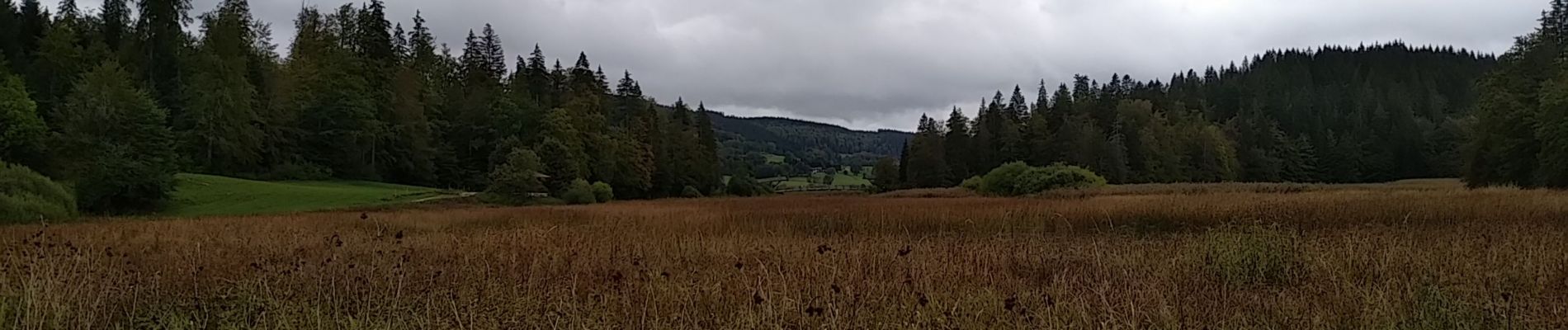
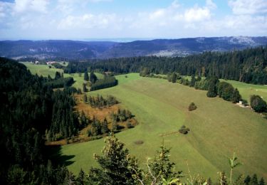
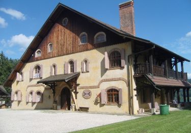
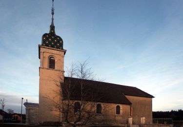
Tocht Stappen van 8 km beschikbaar op Bourgondië-Franche-Comté, Doubs, Montperreux. Deze tocht wordt voorgesteld door helmut68.
Beschrijving
Départ et arrivée rue du Lac à Chaon
Suivre le balisage " jaune bleu " tout le long du parcours.
Ce circuit met en valeur une partie du Lac de Saint Point avec son emblématique et pittoresque hameau du Port Titi qui a des allures de village norvégien avec ses cabanes sur pilotis de couleurs vives. Après avoir passé le village de Oye et Pallet, vous aurez une belle vue sur l’ancien pont sur le Doubs.
Plaatsbepaling
Opmerkingen
Wandeltochten in de omgeving
![Tocht Stappen Les Fourgs - Le Stratégique - Doubs - Photo](https://media.geolcdn.com/t/375/260/ext.jpg?maxdim=2&url=https%3A%2F%2Fservices.sitytrail.com%2FGeolivesWS%2FDownloadMedia.ashx%3FTrailID%3D108935%26Media%3D2626_1.jpg)
![Stappen Stappen](https://static1.geolcdn.com/sitytour/trail-icons/101.png)
Stappen
![](/images/other/stat-length.png)
![](https://static1.geolcdn.com/siteimages/upload/files/16400158638029165_repeat_loop_refresh_sync_direction_icon.png)
![Tocht Stappen Les Fourgs - 2024-01-31_00h34m12_le-belvedere-de-la-roche-sarrasine_randonnee-2285212 - Photo](https://media.geolcdn.com/t/375/260/ext.jpg?maxdim=2&url=https%3A%2F%2Fstatic1.geolcdn.com%2Fsiteimages%2Fupload%2Ffiles%2F1553511878bg_sport_marche.png)
![Stappen Stappen](https://static1.geolcdn.com/sitytour/trail-icons/101.png)
Stappen
![](/images/other/stat-length.png)
![](https://static1.geolcdn.com/siteimages/upload/files/16400158638029165_repeat_loop_refresh_sync_direction_icon.png)
![Tocht Stappen Saint-Antoine - Boucle du fort St Antoine - Photo](https://media.geolcdn.com/t/375/260/39387965-6cd2-4b9c-a9a7-b089cab08bc2.jpg&format=jpg&maxdim=2)
![Stappen Stappen](https://static1.geolcdn.com/sitytour/trail-icons/101.png)
Stappen
![](/images/other/stat-length.png)
![](https://static1.geolcdn.com/siteimages/upload/files/16400158638029165_repeat_loop_refresh_sync_direction_icon.png)
![Tocht Te voet Saint-Point-Lac - La Ronde des Deux Villages - Photo](https://media.geolcdn.com/t/375/260/0971416a-a891-44ca-98b1-126d1c5a4069.jpeg&format=jpg&maxdim=2)
![Te voet Te voet](https://static1.geolcdn.com/sitytour/trail-icons/100.png)
Te voet
![](/images/other/stat-length.png)
![](https://static1.geolcdn.com/siteimages/upload/files/16400158638029165_repeat_loop_refresh_sync_direction_icon.png)
![Tocht Te voet Les Grangettes - La Pierre qui Tourne - Photo](https://media.geolcdn.com/t/375/260/9bc03250-aa40-4533-aaa8-f54e2fea6187.jpeg&format=jpg&maxdim=2)
![Te voet Te voet](https://static1.geolcdn.com/sitytour/trail-icons/100.png)
Te voet
![](/images/other/stat-length.png)
![](https://static1.geolcdn.com/siteimages/upload/files/16400158638029165_repeat_loop_refresh_sync_direction_icon.png)
![Tocht Te voet Malpas - Le Tour du Lac de Malpas - Photo](https://media.geolcdn.com/t/375/260/0837636c-66a1-4405-831a-9c313453c2cb.jpeg&format=jpg&maxdim=2)
![Te voet Te voet](https://static1.geolcdn.com/sitytour/trail-icons/100.png)
Te voet
![](/images/other/stat-length.png)
![](https://static1.geolcdn.com/siteimages/upload/files/16400158638029165_repeat_loop_refresh_sync_direction_icon.png)
![Tocht Te voet Malbuisson - Sentier du Tour du Lac - Photo](https://media.geolcdn.com/t/375/260/ec9f6be9-4d56-4db2-b65f-5890444a2963.jpeg&format=jpg&maxdim=2)
![Te voet Te voet](https://static1.geolcdn.com/sitytour/trail-icons/100.png)
Te voet
![](/images/other/stat-length.png)
![](https://static1.geolcdn.com/siteimages/upload/files/16400158638029165_repeat_loop_refresh_sync_direction_icon.png)
![Tocht Noords wandelen Malbuisson - Fort St Antoine - Photo](https://media.geolcdn.com/t/375/260/fe4e7a22-394a-4da9-be49-1254fdb85bde.jpg&format=jpg&maxdim=2)
![Noords wandelen Noords wandelen](https://static1.geolcdn.com/sitytour/trail-icons/102.png)
Noords wandelen
![](/images/other/stat-length.png)
![](https://static1.geolcdn.com/siteimages/upload/files/16400158638029165_repeat_loop_refresh_sync_direction_icon.png)
![Tocht Langlaufen Les Hôpitaux-Vieux - Les Essarts - Photo](https://media.geolcdn.com/t/375/260/133bf42f-84e7-4637-b480-7581e8a779ca.jpg&format=jpg&maxdim=2)
![Langlaufen Langlaufen](https://static1.geolcdn.com/sitytour/trail-icons/502.png)
Langlaufen
![](/images/other/stat-length.png)
![](https://static1.geolcdn.com/siteimages/upload/files/16400158638029165_repeat_loop_refresh_sync_direction_icon.png)