![](/images/other/stat-length.png)
![Tocht Stappen Le Mas-d'Agenais - ASPTT du 2014 -03-13 - Photo](https://media.geolcdn.com/t/1900/400/ext.pjpeg?maxdim=2&url=https%3A%2F%2Fstatic1.geolcdn.com%2Fsiteimages%2Fupload%2Ffiles%2F1553511878bg_sport_marche.png)
ASPTT du 2014 -03-13
Elbe
Gebruiker
![Lengte](/images/other/stat-length.png)
Lengte
12,6 km
![Max. hoogte](https://static1.geolcdn.com/siteimages/upload/files/1508320355ic_sort_altitude_max_24dp.png)
Max. hoogte
93 m
![Positief hoogteverschil](https://static1.geolcdn.com/siteimages/upload/files/1508320355ic_sort_den_pos_24dp.png)
Positief hoogteverschil
144 m
![Km-Effort](/images/other/stat-length.png)
Km-Effort
14,5 km
![Min. hoogte](https://static1.geolcdn.com/siteimages/upload/files/1508320355ic_sort_altitude_min_24dp.png)
Min. hoogte
27 m
![Negatief hoogteverschil](https://static1.geolcdn.com/siteimages/upload/files/1508320355ic_sort_den_neg_24dp.png)
Negatief hoogteverschil
149 m
![Boucle](https://static1.geolcdn.com/siteimages/upload/files/16400158638029165_repeat_loop_refresh_sync_direction_icon.png)
Boucle
Ja
Datum van aanmaak :
2014-12-10 00:00:00.0
Laatste wijziging :
2014-12-10 00:00:00.0
![Stappen](https://static1.geolcdn.com/sitytour/trail-icons/101.png)
3h10
Moeilijkheid : Medium
![Scan deze QR-code om de tocht te openen in de SityTrail-applicatie](https://capi.geolives.com/qq0zvz2zws4bq2lad0pu/sitytour/trails/256747/qr.png?size=200)
Gratisgps-wandelapplicatie
Over ons
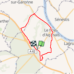
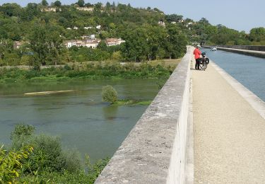
Tocht Stappen van 12,6 km beschikbaar op Nieuw-Aquitanië, Lot-et-Garonne, Le Mas-d'Agenais. Deze tocht wordt voorgesteld door Elbe.
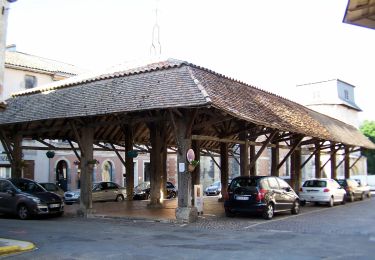
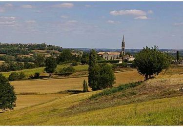
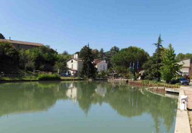
Beschrijving
LE MAS D'AGENAIS
Départ depuis le parking situé sur la D6 à l'entrée de la forêt en direction de Casteljaloux (à DUPRAT).
Plaatsbepaling
Land:
France
Regio :
Nieuw-Aquitanië
Departement/Provincie :
Lot-et-Garonne
Gemeente :
Le Mas-d'Agenais
Locatie:
Unknown
Vertrek:(Dec)
Vertrek:(UTM)
277047 ; 4919556 (31T) N.
Opmerkingen
Wandeltochten in de omgeving
![Tocht Te voet Le Mas-d'Agenais - Le Mas-d'Agenais, du canal à la forêt - 12.8 km - Photo](https://media.geolcdn.com/t/375/260/ext.jpg?maxdim=2&url=https%3A%2F%2Fmedia.geolcdn.com%2Ff%2F9483f168-b009-4edb-809c-04985ca17f66.jpeg)
![Te voet Te voet](https://static1.geolcdn.com/sitytour/trail-icons/100.png)
Le Mas-d'Agenais, du canal à la forêt - 12.8 km
Te voet
Gemakkelijk
Le Mas-d'Agenais,
Nieuw-Aquitanië,
Lot-et-Garonne,
France
![](/images/other/stat-length.png)
12,7 km | 14,6 km-effort
3h 19min
![](https://static1.geolcdn.com/siteimages/upload/files/16400158638029165_repeat_loop_refresh_sync_direction_icon.png)
Ja
![Tocht Te voet Lagruère - Lagruère, dans la boucle de l'Ourbise - 10.6 km - Photo](https://media.geolcdn.com/t/375/260/ext.jpg?maxdim=2&url=https%3A%2F%2Fmedia.geolcdn.com%2Ff%2Fe6168105-4293-459d-9b69-ff9e4bce5c88.jpeg)
![Te voet Te voet](https://static1.geolcdn.com/sitytour/trail-icons/100.png)
Lagruère, dans la boucle de l'Ourbise - 10.6 km
Te voet
Gemakkelijk
Lagruère,
Nieuw-Aquitanië,
Lot-et-Garonne,
France
![](/images/other/stat-length.png)
10,5 km | 11,6 km-effort
2h 37min
![](https://static1.geolcdn.com/siteimages/upload/files/16400158638029165_repeat_loop_refresh_sync_direction_icon.png)
Ja
![Tocht Te voet Calonges - Calonges, balade dans la plaine de la Garonne - 11.8 km - Photo](https://media.geolcdn.com/t/375/260/ext.jpg?maxdim=2&url=https%3A%2F%2Fmedia.geolcdn.com%2Ff%2F4b34dc18-3e8b-4d25-9841-d4ae13f257a2.jpeg)
![Te voet Te voet](https://static1.geolcdn.com/sitytour/trail-icons/100.png)
Calonges, balade dans la plaine de la Garonne - 11.8 km
Te voet
Gemakkelijk
Calonges,
Nieuw-Aquitanië,
Lot-et-Garonne,
France
![](/images/other/stat-length.png)
4,2 km | 4,6 km-effort
1h 3min
![](https://static1.geolcdn.com/siteimages/upload/files/16400158638029165_repeat_loop_refresh_sync_direction_icon.png)
Neen
![Tocht Fietstoerisme Le Mas-d'Agenais - Mas d'Agenais-Agen - Photo](https://media.geolcdn.com/t/375/260/ext.jpg?maxdim=2&url=https%3A%2F%2Fmedia.geolcdn.com%2Ff%2F8876ac7d-3d26-48f5-8ebb-5430a695ec48.jpg)
![Fietstoerisme Fietstoerisme](https://static1.geolcdn.com/sitytour/trail-icons/204.png)
Mas d'Agenais-Agen
Fietstoerisme
Medium
Le Mas-d'Agenais,
Nieuw-Aquitanië,
Lot-et-Garonne,
France
![](/images/other/stat-length.png)
52 km | 58 km-effort
Onbekend
![](https://static1.geolcdn.com/siteimages/upload/files/16400158638029165_repeat_loop_refresh_sync_direction_icon.png)
Neen
![Tocht Te voet Le Mas-d'Agenais - Le Mas-d'Agenais - Les princes des sous-bois en forêt du Mas (Variante) - 5.4 km - Photo](https://media.geolcdn.com/t/375/260/ext.jpg?maxdim=2&url=https%3A%2F%2Fstatic1.geolcdn.com%2Fsiteimages%2Fupload%2Ffiles%2F1545311037marcheuse_200dpi.jpg)
![Te voet Te voet](https://static1.geolcdn.com/sitytour/trail-icons/100.png)
Le Mas-d'Agenais - Les princes des sous-bois en forêt du Mas (Variante) - 5.4 km
Te voet
Gemakkelijk
Le Mas-d'Agenais,
Nieuw-Aquitanië,
Lot-et-Garonne,
France
![](/images/other/stat-length.png)
5,4 km | 6 km-effort
1h 22min
![](https://static1.geolcdn.com/siteimages/upload/files/16400158638029165_repeat_loop_refresh_sync_direction_icon.png)
Ja
![Tocht Te voet Le Mas-d'Agenais - Le Mas-d'Agenais - Les princes des sous-bois en forêt du Mas - 7 km - Photo](https://media.geolcdn.com/t/375/260/ext.jpg?maxdim=2&url=https%3A%2F%2Fstatic1.geolcdn.com%2Fsiteimages%2Fupload%2Ffiles%2F1545311037marcheuse_200dpi.jpg)
![Te voet Te voet](https://static1.geolcdn.com/sitytour/trail-icons/100.png)
Le Mas-d'Agenais - Les princes des sous-bois en forêt du Mas - 7 km
Te voet
Gemakkelijk
Le Mas-d'Agenais,
Nieuw-Aquitanië,
Lot-et-Garonne,
France
![](/images/other/stat-length.png)
7 km | 7,8 km-effort
1h 46min
![](https://static1.geolcdn.com/siteimages/upload/files/16400158638029165_repeat_loop_refresh_sync_direction_icon.png)
Ja
![Tocht Fiets Le Mas-d'Agenais - Liaison Pays du Dropt - Voie Verte du Canal de Garonne - Photo](https://media.geolcdn.com/t/375/260/ext.jpg?maxdim=2&url=https%3A%2F%2Fservices.sitytrail.com%2FGeolivesWS%2FDownloadMedia.ashx%3FTrailID%3D111805%26Media%3D8392_2.jpg)
![Fiets Fiets](https://static1.geolcdn.com/sitytour/trail-icons/200.png)
Liaison Pays du Dropt - Voie Verte du Canal de Garonne
Fiets
Medium
Le Mas-d'Agenais,
Nieuw-Aquitanië,
Lot-et-Garonne,
France
![](/images/other/stat-length.png)
59 km | 68 km-effort
3h 0min
![](https://static1.geolcdn.com/siteimages/upload/files/16400158638029165_repeat_loop_refresh_sync_direction_icon.png)
Neen
![Tocht Mountainbike Le Mas-d'Agenais - Le Mas-d'Agenais, du canal à la forêt - Pays Val de Garonne - Gascogne - Photo](https://media.geolcdn.com/t/375/260/ext.jpg?maxdim=2&url=https%3A%2F%2Fservices.sitytrail.com%2FGeolivesWS%2FDownloadMedia.ashx%3FTrailID%3D110722%26Media%3D6256_1.jpg)
![Mountainbike Mountainbike](https://static1.geolcdn.com/sitytour/trail-icons/202.png)
Le Mas-d'Agenais, du canal à la forêt - Pays Val de Garonne - Gascogne
Mountainbike
Medium
Le Mas-d'Agenais,
Nieuw-Aquitanië,
Lot-et-Garonne,
France
![](/images/other/stat-length.png)
12,7 km | 14,7 km-effort
1h 40min
![](https://static1.geolcdn.com/siteimages/upload/files/16400158638029165_repeat_loop_refresh_sync_direction_icon.png)
Ja
![Tocht Stappen Le Mas-d'Agenais - Le Mas-d'Agenais, du canal à la forêt - Pays Val de Garonne - Gascogne - Photo](https://media.geolcdn.com/t/375/260/ext.jpg?maxdim=2&url=https%3A%2F%2Fservices.sitytrail.com%2FGeolivesWS%2FDownloadMedia.ashx%3FTrailID%3D110721%26Media%3D6256_1.jpg)
![Stappen Stappen](https://static1.geolcdn.com/sitytour/trail-icons/101.png)
Le Mas-d'Agenais, du canal à la forêt - Pays Val de Garonne - Gascogne
Stappen
Medium
(1)
Le Mas-d'Agenais,
Nieuw-Aquitanië,
Lot-et-Garonne,
France
![](/images/other/stat-length.png)
12,7 km | 14,7 km-effort
3h 15min
![](https://static1.geolcdn.com/siteimages/upload/files/16400158638029165_repeat_loop_refresh_sync_direction_icon.png)
Ja