![](/images/other/stat-length.png)
![Tocht Stappen Mézin - circuit Mezin,Gagnet,Trignan,pereou,Route de Fources,la Barthe de Cholle,pui le GR654 E en direction de Mezin,Gagnet et retour à Mezin Jardin Paysagé. - Photo](https://media.geolcdn.com/t/1900/400/2e55d4ce-ca27-4bb1-8bd2-ebb5ef767641.jpg&format=pjpeg&maxdim=2)
circuit Mezin,Gagnet,Trignan,pereou,Route de Fources,la Barthe de Cholle,pui le GR654 E en direction de Mezin,Gagnet et retour à Mezin Jardin Paysagé.
Forsans
Gebruiker
![Lengte](/images/other/stat-length.png)
Lengte
12,1 km
![Max. hoogte](https://static1.geolcdn.com/siteimages/upload/files/1508320355ic_sort_altitude_max_24dp.png)
Max. hoogte
136 m
![Positief hoogteverschil](https://static1.geolcdn.com/siteimages/upload/files/1508320355ic_sort_den_pos_24dp.png)
Positief hoogteverschil
221 m
![Km-Effort](/images/other/stat-length.png)
Km-Effort
15 km
![Min. hoogte](https://static1.geolcdn.com/siteimages/upload/files/1508320355ic_sort_altitude_min_24dp.png)
Min. hoogte
63 m
![Negatief hoogteverschil](https://static1.geolcdn.com/siteimages/upload/files/1508320355ic_sort_den_neg_24dp.png)
Negatief hoogteverschil
221 m
![Boucle](https://static1.geolcdn.com/siteimages/upload/files/16400158638029165_repeat_loop_refresh_sync_direction_icon.png)
Boucle
Ja
Datum van aanmaak :
2020-09-30 14:06:36.604
Laatste wijziging :
2020-09-30 21:33:30.067
![Stappen](https://static1.geolcdn.com/sitytour/trail-icons/101.png)
2h55
Moeilijkheid : Gemakkelijk
![Scan deze QR-code om de tocht te openen in de SityTrail-applicatie](https://capi.geolives.com/qq0zvz2zws4bq2lad0pu/sitytour/trails/2565829/qr.png?size=200)
Gratisgps-wandelapplicatie
Over ons
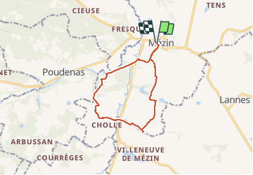
Tocht Stappen van 12,1 km beschikbaar op Nieuw-Aquitanië, Lot-et-Garonne, Mézin. Deze tocht wordt voorgesteld door Forsans.
Beschrijving
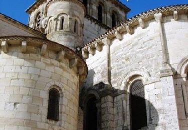
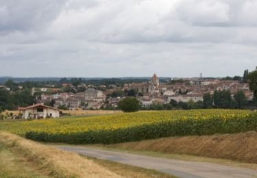
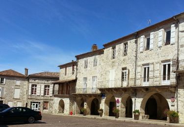
Circuit sur les hauteurs de Mezin et retour par le GR 654E par la voie verte puis bifurcation à l'ancienne garde barrière en direction de Gagnet puis Mezin.
Plaatsbepaling
Land:
France
Regio :
Nieuw-Aquitanië
Departement/Provincie :
Lot-et-Garonne
Gemeente :
Mézin
Locatie:
Unknown
Vertrek:(Dec)
Vertrek:(UTM)
280138 ; 4881740 (31T) N.
Opmerkingen
Wandeltochten in de omgeving
![Tocht Mountainbike Mézin - Mézin, des jardins paysagers à la table d'orientation - Pays d'Albret - Photo](https://media.geolcdn.com/t/375/260/ext.jpg?maxdim=2&url=https%3A%2F%2Fservices.sitytrail.com%2FGeolivesWS%2FDownloadMedia.ashx%3FTrailID%3D110798%26Media%3D6294_1.jpg)
![Mountainbike Mountainbike](https://static1.geolcdn.com/sitytour/trail-icons/202.png)
Mézin, des jardins paysagers à la table d'orientation - Pays d'Albret
Mountainbike
Gemakkelijk
(1)
Mézin,
Nieuw-Aquitanië,
Lot-et-Garonne,
France
![](/images/other/stat-length.png)
4,8 km | 6,1 km-effort
30min
![](https://static1.geolcdn.com/siteimages/upload/files/16400158638029165_repeat_loop_refresh_sync_direction_icon.png)
Ja
![Tocht Mountainbike Mézin - De Mézin, la Médiévale à Poudenas l'Italienne - Pays d'Albret - Photo](https://media.geolcdn.com/t/375/260/ext.jpg?maxdim=2&url=https%3A%2F%2Fservices.sitytrail.com%2FGeolivesWS%2FDownloadMedia.ashx%3FTrailID%3D110795%26Media%3D6293_1.jpg)
![Mountainbike Mountainbike](https://static1.geolcdn.com/sitytour/trail-icons/202.png)
De Mézin, la Médiévale à Poudenas l'Italienne - Pays d'Albret
Mountainbike
Medium
(1)
Mézin,
Nieuw-Aquitanië,
Lot-et-Garonne,
France
![](/images/other/stat-length.png)
14,3 km | 18 km-effort
1h 45min
![](https://static1.geolcdn.com/siteimages/upload/files/16400158638029165_repeat_loop_refresh_sync_direction_icon.png)
Ja
![Tocht Te voet Poudenas - Poudenas, une ambiance de Toscane 10.8 km - Photo](https://media.geolcdn.com/t/375/260/ef3687dd-33b2-428d-9c76-911af79325b2.jpeg&format=jpg&maxdim=2)
![Te voet Te voet](https://static1.geolcdn.com/sitytour/trail-icons/100.png)
Poudenas, une ambiance de Toscane 10.8 km
Te voet
Gemakkelijk
Poudenas,
Nieuw-Aquitanië,
Lot-et-Garonne,
France
![](/images/other/stat-length.png)
10,8 km | 12,8 km-effort
2h 54min
![](https://static1.geolcdn.com/siteimages/upload/files/16400158638029165_repeat_loop_refresh_sync_direction_icon.png)
Ja
![Tocht Te voet Poudenas - Poudenas, une ambiance de Toscane variante 7.8 km - Photo](https://media.geolcdn.com/t/375/260/ef3687dd-33b2-428d-9c76-911af79325b2.jpeg&format=jpg&maxdim=2)
![Te voet Te voet](https://static1.geolcdn.com/sitytour/trail-icons/100.png)
Poudenas, une ambiance de Toscane variante 7.8 km
Te voet
Gemakkelijk
Poudenas,
Nieuw-Aquitanië,
Lot-et-Garonne,
France
![](/images/other/stat-length.png)
7,5 km | 9 km-effort
2h 2min
![](https://static1.geolcdn.com/siteimages/upload/files/16400158638029165_repeat_loop_refresh_sync_direction_icon.png)
Ja
![Tocht Te voet Mézin - De Mézin à Villeneuve-de-Mézin, sur la route de Compostelle 16.6 km - Photo](https://media.geolcdn.com/t/375/260/ae5ee892-264d-47ca-b970-07ea0e883592.jpeg&format=jpg&maxdim=2)
![Te voet Te voet](https://static1.geolcdn.com/sitytour/trail-icons/100.png)
De Mézin à Villeneuve-de-Mézin, sur la route de Compostelle 16.6 km
Te voet
Medium
Mézin,
Nieuw-Aquitanië,
Lot-et-Garonne,
France
![](/images/other/stat-length.png)
18,1 km | 22 km-effort
4h 53min
![](https://static1.geolcdn.com/siteimages/upload/files/16400158638029165_repeat_loop_refresh_sync_direction_icon.png)
Neen
![Tocht Te voet Poudenas - De Mézin, la Médiévale à Poudenas, l'Italienne 14.3 km - Photo](https://media.geolcdn.com/t/375/260/4931e991-4f88-4037-bc7e-658247d6e79b.jpeg&format=jpg&maxdim=2)
![Te voet Te voet](https://static1.geolcdn.com/sitytour/trail-icons/100.png)
De Mézin, la Médiévale à Poudenas, l'Italienne 14.3 km
Te voet
Gemakkelijk
Poudenas,
Nieuw-Aquitanië,
Lot-et-Garonne,
France
![](/images/other/stat-length.png)
14,2 km | 17,9 km-effort
4h 3min
![](https://static1.geolcdn.com/siteimages/upload/files/16400158638029165_repeat_loop_refresh_sync_direction_icon.png)
Ja
![Tocht Te voet Mézin - Mézin, des jardins paysagers à la table d'orientation 4.8 km - Photo](https://media.geolcdn.com/t/375/260/ca3ca46d-f8e9-498b-bff7-554e5a603f77.jpeg&format=jpg&maxdim=2)
![Te voet Te voet](https://static1.geolcdn.com/sitytour/trail-icons/100.png)
Mézin, des jardins paysagers à la table d'orientation 4.8 km
Te voet
Gemakkelijk
Mézin,
Nieuw-Aquitanië,
Lot-et-Garonne,
France
![](/images/other/stat-length.png)
4,8 km | 6,1 km-effort
1h 23min
![](https://static1.geolcdn.com/siteimages/upload/files/16400158638029165_repeat_loop_refresh_sync_direction_icon.png)
Ja
![Tocht Te voet Mézin - Mézin, des jardins paysagers à la table d'orientation variante 3.7 km km - Photo](https://media.geolcdn.com/t/375/260/ae5ee892-264d-47ca-b970-07ea0e883592.jpeg&format=jpg&maxdim=2)
![Te voet Te voet](https://static1.geolcdn.com/sitytour/trail-icons/100.png)
Mézin, des jardins paysagers à la table d'orientation variante 3.7 km km
Te voet
Gemakkelijk
Mézin,
Nieuw-Aquitanië,
Lot-et-Garonne,
France
![](/images/other/stat-length.png)
3,7 km | 4,7 km-effort
1h 3min
![](https://static1.geolcdn.com/siteimages/upload/files/16400158638029165_repeat_loop_refresh_sync_direction_icon.png)
Ja
![Tocht Te voet Lannes - De Lannes à Mézin, le parfum de l'Armagnac-Ténarèze 9.6 km - Photo](https://media.geolcdn.com/t/375/260/bf01d176-dfbc-4f74-9a32-be82b3416151.jpeg&format=jpg&maxdim=2)
![Te voet Te voet](https://static1.geolcdn.com/sitytour/trail-icons/100.png)
De Lannes à Mézin, le parfum de l'Armagnac-Ténarèze 9.6 km
Te voet
Gemakkelijk
Lannes,
Nieuw-Aquitanië,
Lot-et-Garonne,
France
![](/images/other/stat-length.png)
9,9 km | 12,1 km-effort
2h 45min
![](https://static1.geolcdn.com/siteimages/upload/files/16400158638029165_repeat_loop_refresh_sync_direction_icon.png)
Ja