![](/images/other/stat-length.png)
![Tocht Stappen Acquigny - 2020_09_Acquigny_Gruchet - Photo](https://media.geolcdn.com/t/1900/400/ext.pjpeg?maxdim=2&url=https%3A%2F%2Fstatic1.geolcdn.com%2Fsiteimages%2Fupload%2Ffiles%2F1553511878bg_sport_marche.png)
2020_09_Acquigny_Gruchet
jeanlucien
Gebruiker
![Lengte](/images/other/stat-length.png)
Lengte
13,2 km
![Max. hoogte](https://static1.geolcdn.com/siteimages/upload/files/1508320355ic_sort_altitude_max_24dp.png)
Max. hoogte
151 m
![Positief hoogteverschil](https://static1.geolcdn.com/siteimages/upload/files/1508320355ic_sort_den_pos_24dp.png)
Positief hoogteverschil
182 m
![Km-Effort](/images/other/stat-length.png)
Km-Effort
15,6 km
![Min. hoogte](https://static1.geolcdn.com/siteimages/upload/files/1508320355ic_sort_altitude_min_24dp.png)
Min. hoogte
13 m
![Negatief hoogteverschil](https://static1.geolcdn.com/siteimages/upload/files/1508320355ic_sort_den_neg_24dp.png)
Negatief hoogteverschil
181 m
![Boucle](https://static1.geolcdn.com/siteimages/upload/files/16400158638029165_repeat_loop_refresh_sync_direction_icon.png)
Boucle
Ja
Datum van aanmaak :
2020-09-27 07:22:06.525
Laatste wijziging :
2020-09-27 07:25:22.104
![Stappen](https://static1.geolcdn.com/sitytour/trail-icons/101.png)
2h54
Moeilijkheid : Medium
![Scan deze QR-code om de tocht te openen in de SityTrail-applicatie](https://capi.geolives.com/qq0zvz2zws4bq2lad0pu/sitytour/trails/2562480/qr.png?size=200)
Gratisgps-wandelapplicatie
Over ons
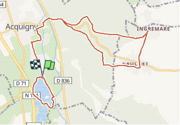
Tocht Stappen van 13,2 km beschikbaar op Normandië, Eure, Acquigny. Deze tocht wordt voorgesteld door jeanlucien.
Beschrijving
Attention pont métallique sur l'Eure barré. Barrières hautes pour personnes agées, d'ou modification du parcours initial 'circuit des etangs)et A/R sur même chemin.
Plaatsbepaling
Land:
France
Regio :
Normandië
Departement/Provincie :
Eure
Gemeente :
Acquigny
Locatie:
Unknown
Vertrek:(Dec)
Vertrek:(UTM)
367728 ; 5446947 (31U) N.
Opmerkingen
Wandeltochten in de omgeving
![Tocht Stappen La Haye-le-Comte - La Haye le Comte - Photo](https://media.geolcdn.com/t/375/260/ext.jpg?maxdim=2&url=https%3A%2F%2Fstatic1.geolcdn.com%2Fsiteimages%2Fupload%2Ffiles%2F1553511878bg_sport_marche.png)
![Stappen Stappen](https://static1.geolcdn.com/sitytour/trail-icons/101.png)
La Haye le Comte
Stappen
Medium
(1)
La Haye-le-Comte,
Normandië,
Eure,
France
![](/images/other/stat-length.png)
12 km | 14,7 km-effort
3h 0min
![](https://static1.geolcdn.com/siteimages/upload/files/16400158638029165_repeat_loop_refresh_sync_direction_icon.png)
Ja
![Stappen Stappen](https://static1.geolcdn.com/sitytour/trail-icons/101.png)
20231012-Amfreville sur Iton
Stappen
Medium
(1)
Amfreville-sur-Iton,
Normandië,
Eure,
France
![](/images/other/stat-length.png)
11,6 km | 14,4 km-effort
3h 17min
![](https://static1.geolcdn.com/siteimages/upload/files/16400158638029165_repeat_loop_refresh_sync_direction_icon.png)
Ja
![Tocht Wegfiets Pinterville - Pinterville aller retour - Photo](https://media.geolcdn.com/t/375/260/8eeb09f6-87db-4d49-a311-8b1c5c1f2921.jpg&format=jpg&maxdim=2)
![Wegfiets Wegfiets](https://static1.geolcdn.com/sitytour/trail-icons/201.png)
Pinterville aller retour
Wegfiets
Heel gemakkelijk
Pinterville,
Normandië,
Eure,
France
![](/images/other/stat-length.png)
59 km | 65 km-effort
3h 44min
![](https://static1.geolcdn.com/siteimages/upload/files/16400158638029165_repeat_loop_refresh_sync_direction_icon.png)
Ja
![Tocht Stappen Amfreville-sur-Iton - rando amfreville sur iton - Photo](https://media.geolcdn.com/t/375/260/1ae1478e-8362-45f5-95df-868478733425.jpg&format=jpg&maxdim=2)
![Stappen Stappen](https://static1.geolcdn.com/sitytour/trail-icons/101.png)
rando amfreville sur iton
Stappen
Medium
Amfreville-sur-Iton,
Normandië,
Eure,
France
![](/images/other/stat-length.png)
12,5 km | 15,4 km-effort
3h 18min
![](https://static1.geolcdn.com/siteimages/upload/files/16400158638029165_repeat_loop_refresh_sync_direction_icon.png)
Ja
![Tocht Stappen Heudebouville - 20230202-Heudebouville - Photo](https://media.geolcdn.com/t/375/260/9a040f26-251c-4887-9b11-b6efcdf3ee8d.jpg&format=jpg&maxdim=2)
![Stappen Stappen](https://static1.geolcdn.com/sitytour/trail-icons/101.png)
20230202-Heudebouville
Stappen
Medium
Heudebouville,
Normandië,
Eure,
France
![](/images/other/stat-length.png)
12,1 km | 15,1 km-effort
3h 55min
![](https://static1.geolcdn.com/siteimages/upload/files/16400158638029165_repeat_loop_refresh_sync_direction_icon.png)
Ja
![Stappen Stappen](https://static1.geolcdn.com/sitytour/trail-icons/101.png)
20220628-Heudreville le Jardin de René
Stappen
Medium
Heudreville-sur-Eure,
Normandië,
Eure,
France
![](/images/other/stat-length.png)
12 km | 14,1 km-effort
3h 37min
![](https://static1.geolcdn.com/siteimages/upload/files/16400158638029165_repeat_loop_refresh_sync_direction_icon.png)
Ja
![Stappen Stappen](https://static1.geolcdn.com/sitytour/trail-icons/101.png)
20220129-Amfreville sur Iton
Stappen
Medium
Amfreville-sur-Iton,
Normandië,
Eure,
France
![](/images/other/stat-length.png)
11,4 km | 14,2 km-effort
3h 5min
![](https://static1.geolcdn.com/siteimages/upload/files/16400158638029165_repeat_loop_refresh_sync_direction_icon.png)
Ja
![Tocht Wegfiets Acquigny - Acquis y rando vélo - Photo](https://media.geolcdn.com/t/375/260/ef4ceab2-1345-4b6b-a40a-ecfa46ab375d.jpg&format=jpg&maxdim=2)
![Wegfiets Wegfiets](https://static1.geolcdn.com/sitytour/trail-icons/201.png)
![Tocht Stappen Acquigny - Acquigny -Vers le Becdal par la mare Hermier - Photo](https://media.geolcdn.com/t/375/260/ef76d62e-c014-482a-b5da-dbf90d427cbf.jpg&format=jpg&maxdim=2)
![Stappen Stappen](https://static1.geolcdn.com/sitytour/trail-icons/101.png)
Acquigny -Vers le Becdal par la mare Hermier
Stappen
Medium
Acquigny,
Normandië,
Eure,
France
![](/images/other/stat-length.png)
13,3 km | 16 km-effort
3h 41min
![](https://static1.geolcdn.com/siteimages/upload/files/16400158638029165_repeat_loop_refresh_sync_direction_icon.png)
Ja