![](/images/other/stat-length.png)
![Tocht Stappen Sorges et Ligueux en Périgord - Les Potences Chauveyrou 9km - Photo](https://media.geolcdn.com/t/1900/400/ext.pjpeg?maxdim=2&url=https%3A%2F%2Fstatic1.geolcdn.com%2Fsiteimages%2Fupload%2Ffiles%2F1553511878bg_sport_marche.png)
Les Potences Chauveyrou 9km
YV24
Gebruiker
![Lengte](/images/other/stat-length.png)
Lengte
8,7 km
![Max. hoogte](https://static1.geolcdn.com/siteimages/upload/files/1508320355ic_sort_altitude_max_24dp.png)
Max. hoogte
194 m
![Positief hoogteverschil](https://static1.geolcdn.com/siteimages/upload/files/1508320355ic_sort_den_pos_24dp.png)
Positief hoogteverschil
202 m
![Km-Effort](/images/other/stat-length.png)
Km-Effort
11,4 km
![Min. hoogte](https://static1.geolcdn.com/siteimages/upload/files/1508320355ic_sort_altitude_min_24dp.png)
Min. hoogte
123 m
![Negatief hoogteverschil](https://static1.geolcdn.com/siteimages/upload/files/1508320355ic_sort_den_neg_24dp.png)
Negatief hoogteverschil
202 m
![Boucle](https://static1.geolcdn.com/siteimages/upload/files/16400158638029165_repeat_loop_refresh_sync_direction_icon.png)
Boucle
Ja
Datum van aanmaak :
2015-04-13 00:00:00.0
Laatste wijziging :
2015-04-13 00:00:00.0
![Stappen](https://static1.geolcdn.com/sitytour/trail-icons/101.png)
2h30
Moeilijkheid : Gemakkelijk
![Scan deze QR-code om de tocht te openen in de SityTrail-applicatie](https://capi.geolives.com/qq0zvz2zws4bq2lad0pu/sitytour/trails/256143/qr.png?size=200)
Gratisgps-wandelapplicatie
Over ons
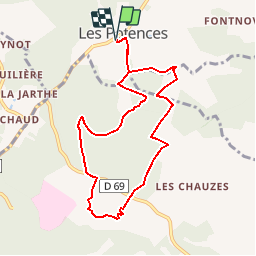
Tocht Stappen van 8,7 km beschikbaar op Nieuw-Aquitanië, Dordogne, Sorges et Ligueux en Périgord. Deze tocht wordt voorgesteld door YV24.
Beschrijving
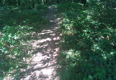
ATTENTION circuit non balisé. Parcours en forêt de Lanmary. Au départ du parking des Potences, hameau de Sorges. Tracé ombragé avec très peu de route
Plaatsbepaling
Land:
France
Regio :
Nieuw-Aquitanië
Departement/Provincie :
Dordogne
Gemeente :
Sorges et Ligueux en Périgord
Locatie:
Unknown
Vertrek:(Dec)
Vertrek:(UTM)
329480 ; 5014371 (31T) N.
Opmerkingen
Wandeltochten in de omgeving
![Tocht Stappen Antonne-et-Trigonant - Lanmary variente 1 - Photo](https://media.geolcdn.com/t/375/260/401f1b0e-efaf-4088-b5dc-ed2841cc4d88.jpg&format=jpg&maxdim=2)
![Stappen Stappen](https://static1.geolcdn.com/sitytour/trail-icons/101.png)
Lanmary variente 1
Stappen
Medium
(1)
Antonne-et-Trigonant,
Nieuw-Aquitanië,
Dordogne,
France
![](/images/other/stat-length.png)
8,4 km | 10,4 km-effort
2h 52min
![](https://static1.geolcdn.com/siteimages/upload/files/16400158638029165_repeat_loop_refresh_sync_direction_icon.png)
Ja
![Tocht Stappen Sorges et Ligueux en Périgord - Sorges Causses et sous bois 10 km - Photo](https://media.geolcdn.com/t/375/260/ext.jpg?maxdim=2&url=https%3A%2F%2Fstatic1.geolcdn.com%2Fsiteimages%2Fupload%2Ffiles%2F1553511878bg_sport_marche.png)
![Stappen Stappen](https://static1.geolcdn.com/sitytour/trail-icons/101.png)
Sorges Causses et sous bois 10 km
Stappen
Gemakkelijk
(1)
Sorges et Ligueux en Périgord,
Nieuw-Aquitanië,
Dordogne,
France
![](/images/other/stat-length.png)
9,9 km | 12,6 km-effort
1h 49min
![](https://static1.geolcdn.com/siteimages/upload/files/16400158638029165_repeat_loop_refresh_sync_direction_icon.png)
Ja
![Tocht Stappen Sorges et Ligueux en Périgord - Sorges Téléthon 2013 11km - Photo](https://media.geolcdn.com/t/375/260/ext.jpg?maxdim=2&url=https%3A%2F%2Fstatic1.geolcdn.com%2Fsiteimages%2Fupload%2Ffiles%2F1553511878bg_sport_marche.png)
![Stappen Stappen](https://static1.geolcdn.com/sitytour/trail-icons/101.png)
Sorges Téléthon 2013 11km
Stappen
Gemakkelijk
(1)
Sorges et Ligueux en Périgord,
Nieuw-Aquitanië,
Dordogne,
France
![](/images/other/stat-length.png)
11 km | 13,2 km-effort
2h 57min
![](https://static1.geolcdn.com/siteimages/upload/files/16400158638029165_repeat_loop_refresh_sync_direction_icon.png)
Ja
![Tocht Stappen Sorges et Ligueux en Périgord - De Sorges à Perigueux sur la voie de Compostelle - Photo](https://media.geolcdn.com/t/375/260/4aaf4236-90c5-474d-8de9-7f6175f80c96.jpeg&format=jpg&maxdim=2)
![Stappen Stappen](https://static1.geolcdn.com/sitytour/trail-icons/101.png)
De Sorges à Perigueux sur la voie de Compostelle
Stappen
Zeer moeilijk
Sorges et Ligueux en Périgord,
Nieuw-Aquitanië,
Dordogne,
France
![](/images/other/stat-length.png)
25 km | 31 km-effort
5h 26min
![](https://static1.geolcdn.com/siteimages/upload/files/16400158638029165_repeat_loop_refresh_sync_direction_icon.png)
Neen
![Tocht Noords wandelen Antonne-et-Trigonant - Lanmary Sibaudie à l'envers - Photo](https://media.geolcdn.com/t/375/260/ext.jpg?maxdim=2&url=https%3A%2F%2Fstatic1.geolcdn.com%2Fsiteimages%2Fupload%2Ffiles%2F1545311037marcheuse_200dpi.jpg)
![Noords wandelen Noords wandelen](https://static1.geolcdn.com/sitytour/trail-icons/102.png)
Lanmary Sibaudie à l'envers
Noords wandelen
Heel gemakkelijk
(2)
Antonne-et-Trigonant,
Nieuw-Aquitanië,
Dordogne,
France
![](/images/other/stat-length.png)
11,8 km | 15,1 km-effort
2h 51min
![](https://static1.geolcdn.com/siteimages/upload/files/16400158638029165_repeat_loop_refresh_sync_direction_icon.png)
Ja
![Tocht Noords wandelen Antonne-et-Trigonant - Lanmary 8,7 km - Photo](https://media.geolcdn.com/t/375/260/ext.jpg?maxdim=2&url=https%3A%2F%2Fstatic1.geolcdn.com%2Fsiteimages%2Fupload%2Ffiles%2F1545311037marcheuse_200dpi.jpg)
![Noords wandelen Noords wandelen](https://static1.geolcdn.com/sitytour/trail-icons/102.png)
Lanmary 8,7 km
Noords wandelen
Gemakkelijk
(1)
Antonne-et-Trigonant,
Nieuw-Aquitanië,
Dordogne,
France
![](/images/other/stat-length.png)
8,7 km | 10,5 km-effort
1h 58min
![](https://static1.geolcdn.com/siteimages/upload/files/16400158638029165_repeat_loop_refresh_sync_direction_icon.png)
Ja
![Tocht Noords wandelen Antonne-et-Trigonant - lanmary 9.7 - Photo](https://media.geolcdn.com/t/375/260/ext.jpg?maxdim=2&url=https%3A%2F%2Fstatic1.geolcdn.com%2Fsiteimages%2Fupload%2Ffiles%2F1545311037marcheuse_200dpi.jpg)
![Noords wandelen Noords wandelen](https://static1.geolcdn.com/sitytour/trail-icons/102.png)
lanmary 9.7
Noords wandelen
Heel gemakkelijk
(1)
Antonne-et-Trigonant,
Nieuw-Aquitanië,
Dordogne,
France
![](/images/other/stat-length.png)
9,8 km | 12,2 km-effort
2h 13min
![](https://static1.geolcdn.com/siteimages/upload/files/16400158638029165_repeat_loop_refresh_sync_direction_icon.png)
Ja
![Tocht Noords wandelen Antonne-et-Trigonant - lanmary 11 km - Photo](https://media.geolcdn.com/t/375/260/ext.jpg?maxdim=2&url=https%3A%2F%2Fstatic1.geolcdn.com%2Fsiteimages%2Fupload%2Ffiles%2F1545311037marcheuse_200dpi.jpg)
![Noords wandelen Noords wandelen](https://static1.geolcdn.com/sitytour/trail-icons/102.png)
lanmary 11 km
Noords wandelen
Heel gemakkelijk
(1)
Antonne-et-Trigonant,
Nieuw-Aquitanië,
Dordogne,
France
![](/images/other/stat-length.png)
11,1 km | 13,7 km-effort
2h 39min
![](https://static1.geolcdn.com/siteimages/upload/files/16400158638029165_repeat_loop_refresh_sync_direction_icon.png)
Ja
![Tocht Noords wandelen Antonne-et-Trigonant - Croix du Rat - Photo](https://media.geolcdn.com/t/375/260/ext.jpg?maxdim=2&url=https%3A%2F%2Fstatic1.geolcdn.com%2Fsiteimages%2Fupload%2Ffiles%2F1545311037marcheuse_200dpi.jpg)
![Noords wandelen Noords wandelen](https://static1.geolcdn.com/sitytour/trail-icons/102.png)
Croix du Rat
Noords wandelen
Heel gemakkelijk
(1)
Antonne-et-Trigonant,
Nieuw-Aquitanië,
Dordogne,
France
![](/images/other/stat-length.png)
10,8 km | 13,4 km-effort
2h 28min
![](https://static1.geolcdn.com/siteimages/upload/files/16400158638029165_repeat_loop_refresh_sync_direction_icon.png)
Ja