![](/images/other/stat-length.png)
![Tocht Stappen Saint-Germain-de-Calberte - Stevenson J12 (St-Germain-de-Calberte à St-Jean-du-Gard) 23 150m +595m - Photo](https://media.geolcdn.com/t/1900/400/ext.pjpeg?maxdim=2&url=https%3A%2F%2Fstatic1.geolcdn.com%2Fsiteimages%2Fupload%2Ffiles%2F1553511878bg_sport_marche.png)
Stevenson J12 (St-Germain-de-Calberte à St-Jean-du-Gard) 23 150m +595m
DanielROLLET
Gebruiker
![Lengte](/images/other/stat-length.png)
![Max. hoogte](https://static1.geolcdn.com/siteimages/upload/files/1508320355ic_sort_altitude_max_24dp.png)
![Positief hoogteverschil](https://static1.geolcdn.com/siteimages/upload/files/1508320355ic_sort_den_pos_24dp.png)
![Km-Effort](/images/other/stat-length.png)
![Min. hoogte](https://static1.geolcdn.com/siteimages/upload/files/1508320355ic_sort_altitude_min_24dp.png)
![Negatief hoogteverschil](https://static1.geolcdn.com/siteimages/upload/files/1508320355ic_sort_den_neg_24dp.png)
![Boucle](https://static1.geolcdn.com/siteimages/upload/files/16400158638029165_repeat_loop_refresh_sync_direction_icon.png)
![Stappen](https://static1.geolcdn.com/sitytour/trail-icons/101.png)
7h15
Moeilijkheid : Moeilijk
![Scan deze QR-code om de tocht te openen in de SityTrail-applicatie](https://capi.geolives.com/qq0zvz2zws4bq2lad0pu/sitytour/trails/2560579/qr.png?size=200)
Gratisgps-wandelapplicatie
Over ons
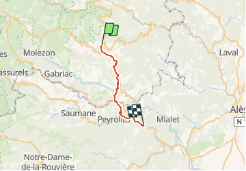
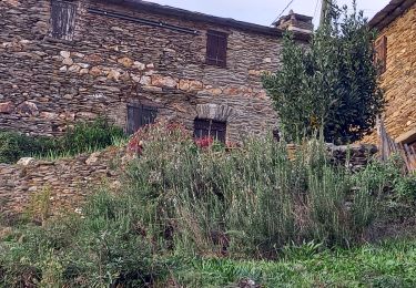
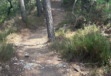
Tocht Stappen van 23 km beschikbaar op Occitanië, Lozère, Saint-Germain-de-Calberte. Deze tocht wordt voorgesteld door DanielROLLET.
Beschrijving
2020 09 24 - 08:00 à 15:15 compris arrêts et pause 12:40 à 13:30 au col de St-Pierre
Départ chambre d'hôtes "chez Gatou" à St-Germain-de-Calberte à l'auberge du Peras à St-Jean-du-Gard
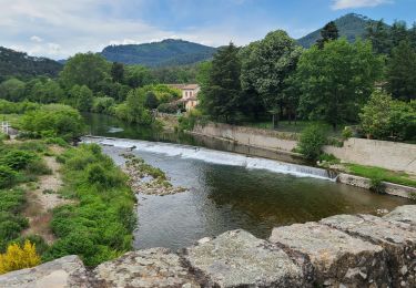
Arrivée St-Jean-du-Gard sous la pluie depuis 1h00
Itinéraire modifié aux abords de St-Jean-du-Gard suite à crues du Gardon.
Plaatsbepaling
Opmerkingen
Wandeltochten in de omgeving
![Tocht Stappen Saint-Germain-de-Calberte - Stevenson Saint Germain de Calberte Saint Jean du Gard - Photo](https://media.geolcdn.com/t/375/260/ed1caeb9-efdf-4967-a644-947357098d2d.jpg&format=jpg&maxdim=2)
![Stappen Stappen](https://static1.geolcdn.com/sitytour/trail-icons/101.png)
Stappen
![](/images/other/stat-length.png)
![](https://static1.geolcdn.com/siteimages/upload/files/16400158638029165_repeat_loop_refresh_sync_direction_icon.png)
![Tocht Te voet Saint-Germain-de-Calberte - Sentier des Rocs de Galta - Photo](https://media.geolcdn.com/t/375/260/7b519e0d-2e42-4eee-b739-79624893d467.jpeg&format=jpg&maxdim=2)
![Te voet Te voet](https://static1.geolcdn.com/sitytour/trail-icons/100.png)
Te voet
![](/images/other/stat-length.png)
![](https://static1.geolcdn.com/siteimages/upload/files/16400158638029165_repeat_loop_refresh_sync_direction_icon.png)
![Tocht Stappen Saint-Germain-de-Calberte - st germain de calberte - Photo](https://media.geolcdn.com/t/375/260/87eeb041-cc74-4ba2-9ba8-32045268c777.jpg&format=jpg&maxdim=2)
![Stappen Stappen](https://static1.geolcdn.com/sitytour/trail-icons/101.png)
Stappen
![](/images/other/stat-length.png)
![](https://static1.geolcdn.com/siteimages/upload/files/16400158638029165_repeat_loop_refresh_sync_direction_icon.png)
![Tocht Stappen Saint-Étienne-Vallée-Française - 16-05-2023 E11 Le Pont de Burgen - Saint Jean du Gard - Photo](https://media.geolcdn.com/t/375/260/ff03ff08-81d3-4040-98d4-ea63d024c58a.jpg&format=jpg&maxdim=2)
![Stappen Stappen](https://static1.geolcdn.com/sitytour/trail-icons/101.png)
Stappen
![](/images/other/stat-length.png)
![](https://static1.geolcdn.com/siteimages/upload/files/16400158638029165_repeat_loop_refresh_sync_direction_icon.png)
![Tocht Stappen Saint-Étienne-Vallée-Française - Montagne vieille morte - Photo](https://media.geolcdn.com/t/375/260/cd3e3ddf-cab8-402e-b474-e6f2e75aa736.jpg&format=jpg&maxdim=2)
![Stappen Stappen](https://static1.geolcdn.com/sitytour/trail-icons/101.png)
Stappen
![](/images/other/stat-length.png)
![](https://static1.geolcdn.com/siteimages/upload/files/16400158638029165_repeat_loop_refresh_sync_direction_icon.png)
![Tocht Te voet Saint-Germain-de-Calberte - La Flandonenque - Photo](https://media.geolcdn.com/t/375/260/a5cf2c6f-e67e-448b-83ec-9810d7980fa9.jpeg&format=jpg&maxdim=2)
![Te voet Te voet](https://static1.geolcdn.com/sitytour/trail-icons/100.png)
Te voet
![](/images/other/stat-length.png)
![](https://static1.geolcdn.com/siteimages/upload/files/16400158638029165_repeat_loop_refresh_sync_direction_icon.png)
![Tocht Mountainbike Saint-Germain-de-Calberte - St Germain de Calberte - St Jean du Gard - Photo](https://media.geolcdn.com/t/375/260/ext.jpg?maxdim=2&url=https%3A%2F%2Fstatic1.geolcdn.com%2Fsiteimages%2Fupload%2Ffiles%2F1524743154velo.jpg)
![Mountainbike Mountainbike](https://static1.geolcdn.com/sitytour/trail-icons/202.png)
Mountainbike
![](/images/other/stat-length.png)
![](https://static1.geolcdn.com/siteimages/upload/files/16400158638029165_repeat_loop_refresh_sync_direction_icon.png)
![Tocht sport Saint-Germain-de-Calberte - Saint-Jean du Gard - Photo](https://media.geolcdn.com/t/375/260/4f2ac59f-3f26-44c5-bfe4-509a884973fb.jpg&format=jpg&maxdim=2)
sport
![](/images/other/stat-length.png)
![](https://static1.geolcdn.com/siteimages/upload/files/16400158638029165_repeat_loop_refresh_sync_direction_icon.png)
![Tocht Stappen Saint-Étienne-Vallée-Française - Stevenson Pont de Burgen - Saint Jean du Gard - Photo](https://media.geolcdn.com/t/375/260/5cbf1fc5-a62c-4fc3-a8b3-6170ff9ae52f.jpg&format=jpg&maxdim=2)
![Stappen Stappen](https://static1.geolcdn.com/sitytour/trail-icons/101.png)
Stappen
![](/images/other/stat-length.png)
![](https://static1.geolcdn.com/siteimages/upload/files/16400158638029165_repeat_loop_refresh_sync_direction_icon.png)