![](/images/other/stat-length.png)
![Tocht Te voet Vertaizon - 2020-09-09_20h57m44_iti0370 (1) - Photo](https://media.geolcdn.com/t/1900/400/ext.pjpeg?maxdim=2&url=https%3A%2F%2Fstatic1.geolcdn.com%2Fsiteimages%2Fupload%2Ffiles%2F1545311037marcheuse_200dpi.jpg)
2020-09-09_20h57m44_iti0370 (1)
jeanic63
Gebruiker
![Lengte](/images/other/stat-length.png)
![Max. hoogte](https://static1.geolcdn.com/siteimages/upload/files/1508320355ic_sort_altitude_max_24dp.png)
![Positief hoogteverschil](https://static1.geolcdn.com/siteimages/upload/files/1508320355ic_sort_den_pos_24dp.png)
![Km-Effort](/images/other/stat-length.png)
![Min. hoogte](https://static1.geolcdn.com/siteimages/upload/files/1508320355ic_sort_altitude_min_24dp.png)
![Negatief hoogteverschil](https://static1.geolcdn.com/siteimages/upload/files/1508320355ic_sort_den_neg_24dp.png)
![Boucle](https://static1.geolcdn.com/siteimages/upload/files/16400158638029165_repeat_loop_refresh_sync_direction_icon.png)
![Te voet](https://static1.geolcdn.com/sitytour/trail-icons/100.png)
--
Moeilijkheid : Medium
![Scan deze QR-code om de tocht te openen in de SityTrail-applicatie](https://capi.geolives.com/qq0zvz2zws4bq2lad0pu/sitytour/trails/2544926/qr.png?size=200)
Gratisgps-wandelapplicatie
Over ons
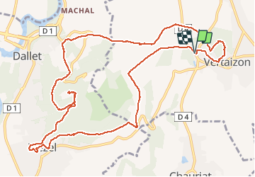
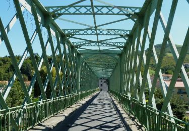
Tocht Te voet van 14,4 km beschikbaar op Auvergne-Rhône-Alpes, Puy-de-Dôme, Vertaizon. Deze tocht wordt voorgesteld door jeanic63.
Beschrijving
Départ : du panneau de départ (Fontaine-lavoir), monter à gauche vers le village par la rue de la
Croix de Laire Basse puis chemin des Noyeraies. Emprunter successivement la rue de la Paix, la rue du
Marchidial, les escaliers et la rue de l'Ancienne Église. A la fourche, monter à gauche pour rejoindre le
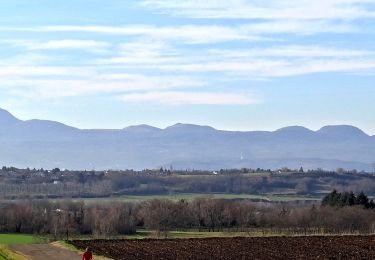
sommet de la butte (Chapelle) et la table d'orientation (vue sur la Chaîne des puys et la Limagne). Traverser
le parc, et descendre par le chemin herbeux. Prendre à droite la rue de la Croix de Laire Haute sur 200
mètres et tourner à droite dans le premier chemin pour rejoindre la route (rue Chatel Vieux)
Plaatsbepaling
Opmerkingen
Wandeltochten in de omgeving
![Stappen Stappen](https://static1.geolcdn.com/sitytour/trail-icons/101.png)
Stappen
![](/images/other/stat-length.png)
![](https://static1.geolcdn.com/siteimages/upload/files/16400158638029165_repeat_loop_refresh_sync_direction_icon.png)
![Tocht Te voet Pont-du-Château - Le Chemin des Batteliers - Photo](https://media.geolcdn.com/t/375/260/637fc0b7-6f7b-4d79-bd2a-b9e0ef453060.jpeg&format=jpg&maxdim=2)
![Te voet Te voet](https://static1.geolcdn.com/sitytour/trail-icons/100.png)
Te voet
![](/images/other/stat-length.png)
![](https://static1.geolcdn.com/siteimages/upload/files/16400158638029165_repeat_loop_refresh_sync_direction_icon.png)
![Tocht Te voet Chauriat - Les Coteaux de Chauriat - Photo](https://media.geolcdn.com/t/375/260/22764b45-9f0b-44c4-add1-6828685091f3.jpeg&format=jpg&maxdim=2)
![Te voet Te voet](https://static1.geolcdn.com/sitytour/trail-icons/100.png)
Te voet
![](/images/other/stat-length.png)
![](https://static1.geolcdn.com/siteimages/upload/files/16400158638029165_repeat_loop_refresh_sync_direction_icon.png)
![Tocht Te voet Billom - Le Turluron - Photo](https://media.geolcdn.com/t/375/260/04f9185b-8c18-47a2-9818-7864122e3458.jpeg&format=jpg&maxdim=2)
![Te voet Te voet](https://static1.geolcdn.com/sitytour/trail-icons/100.png)
Te voet
![](/images/other/stat-length.png)
![](https://static1.geolcdn.com/siteimages/upload/files/16400158638029165_repeat_loop_refresh_sync_direction_icon.png)
![Tocht Te voet Pont-du-Château - De Marchal a Cortal - Photo](https://media.geolcdn.com/t/375/260/0d71d93f-0494-4f38-8dbd-186ec2593344.jpeg&format=jpg&maxdim=2)
![Te voet Te voet](https://static1.geolcdn.com/sitytour/trail-icons/100.png)
Te voet
![](/images/other/stat-length.png)
![](https://static1.geolcdn.com/siteimages/upload/files/16400158638029165_repeat_loop_refresh_sync_direction_icon.png)
![Tocht Te voet Cournon-d'Auvergne - Bords d'Allier - Photo](https://media.geolcdn.com/t/375/260/c86b1688-88d6-4d0e-9afc-08dc5b1f9cef.jpeg&format=jpg&maxdim=2)
![Te voet Te voet](https://static1.geolcdn.com/sitytour/trail-icons/100.png)
Te voet
![](/images/other/stat-length.png)
![](https://static1.geolcdn.com/siteimages/upload/files/16400158638029165_repeat_loop_refresh_sync_direction_icon.png)
![Tocht Mountainbike Pont-du-Château - La Tonytruante - Pont du Château - Photo](https://media.geolcdn.com/t/375/260/ext.jpg?maxdim=2&url=https%3A%2F%2Fstatic1.geolcdn.com%2Fsiteimages%2Fupload%2Ffiles%2F1524743154velo.jpg)
![Mountainbike Mountainbike](https://static1.geolcdn.com/sitytour/trail-icons/202.png)
Mountainbike
![](/images/other/stat-length.png)
![](https://static1.geolcdn.com/siteimages/upload/files/16400158638029165_repeat_loop_refresh_sync_direction_icon.png)
![Tocht Te voet Seychalles - La Tour de Courcourt - Photo](https://media.geolcdn.com/t/375/260/488550a5-a975-46c3-b3c1-9493c7f0199b.jpeg&format=jpg&maxdim=2)
![Te voet Te voet](https://static1.geolcdn.com/sitytour/trail-icons/100.png)
Te voet
![](/images/other/stat-length.png)
![](https://static1.geolcdn.com/siteimages/upload/files/16400158638029165_repeat_loop_refresh_sync_direction_icon.png)
![Tocht Te voet Mur-sur-Allier - De l'Allier au Puy de Mur - Photo](https://media.geolcdn.com/t/375/260/6c7c4f22-7ed8-4746-b8e8-abf236ae1eb1.jpeg&format=jpg&maxdim=2)
![Te voet Te voet](https://static1.geolcdn.com/sitytour/trail-icons/100.png)
Te voet
![](/images/other/stat-length.png)
![](https://static1.geolcdn.com/siteimages/upload/files/16400158638029165_repeat_loop_refresh_sync_direction_icon.png)