![](/images/other/stat-length.png)
![Tocht Stappen Freissinières - 2020-09-08 Marche Dormillouse Lacs Palluel Faravel Fangeas - Photo](https://media.geolcdn.com/t/1900/400/21169251-c2dd-4994-a63e-6ea6e20b7955.jpg&format=pjpeg&maxdim=2)
2020-09-08 Marche Dormillouse Lacs Palluel Faravel Fangeas
holtzv
Gebruiker GUIDE
![Lengte](/images/other/stat-length.png)
![Max. hoogte](https://static1.geolcdn.com/siteimages/upload/files/1508320355ic_sort_altitude_max_24dp.png)
![Positief hoogteverschil](https://static1.geolcdn.com/siteimages/upload/files/1508320355ic_sort_den_pos_24dp.png)
![Km-Effort](/images/other/stat-length.png)
![Min. hoogte](https://static1.geolcdn.com/siteimages/upload/files/1508320355ic_sort_altitude_min_24dp.png)
![Negatief hoogteverschil](https://static1.geolcdn.com/siteimages/upload/files/1508320355ic_sort_den_neg_24dp.png)
![Boucle](https://static1.geolcdn.com/siteimages/upload/files/16400158638029165_repeat_loop_refresh_sync_direction_icon.png)
![Stappen](https://static1.geolcdn.com/sitytour/trail-icons/101.png)
5h57
Moeilijkheid : Medium
![Scan deze QR-code om de tocht te openen in de SityTrail-applicatie](https://capi.geolives.com/qq0zvz2zws4bq2lad0pu/sitytour/trails/2543436/qr.png?size=200)
Gratisgps-wandelapplicatie
Over ons
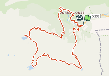
Tocht Stappen van 16,1 km beschikbaar op Provence-Alpes-Côte d'Azur, Hautes-Alpes, Freissinières. Deze tocht wordt voorgesteld door holtzv.
Beschrijving
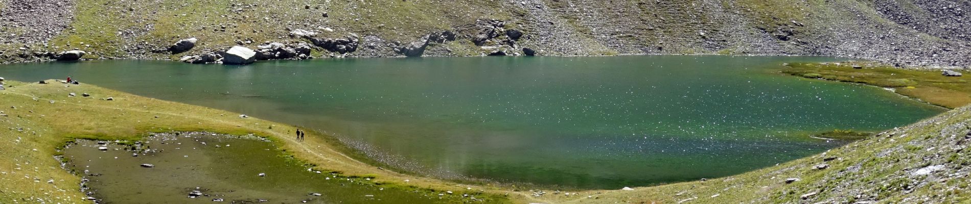
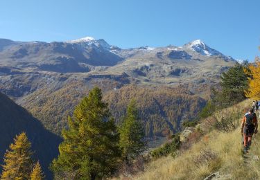
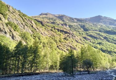
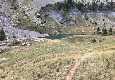
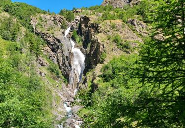
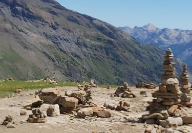
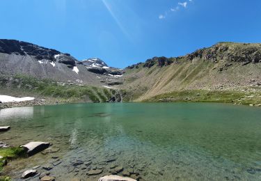
Le début de la marche se fait à travers les petits hameaux de Dormillouse avant de continuer la montée au frais dans la forêt. Arrivée au premier lac de la journée, le lac Palluel (alt 2468m), pour la pause de midi, on enchaine avec le lac de Faravel (alt 2386m) en passant par une mer de Kern. On atteint le troisième Lac de Fangeas (alt 1990m) en passant par le pont de fer. La redescente à travers la forêt offre de beaux points de vue sur le torrent des Oules et la cascade de Dormillouse.
Plaatsbepaling
Opmerkingen
Wandeltochten in de omgeving
![Tocht Stappen Freissinières - les 3 lacs : Palluel, Faravel et Fangeas + montée grand Pinier - Photo](https://media.geolcdn.com/t/375/260/ext.jpg?maxdim=2&url=https%3A%2F%2Fservices.sitytrail.com%2FGeolivesWS%2FDownloadMedia.ashx%3FTrailID%3D213821%26Media%3Dfix__20130816161219.jpg)
![Stappen Stappen](https://static1.geolcdn.com/sitytour/trail-icons/101.png)
Stappen
![](/images/other/stat-length.png)
![](https://static1.geolcdn.com/siteimages/upload/files/16400158638029165_repeat_loop_refresh_sync_direction_icon.png)
![Tocht Stappen Freissinières - Trois lacs de Dormillouse - Photo](https://media.geolcdn.com/t/375/260/ext.jpg?maxdim=2&url=https%3A%2F%2Fstatic1.geolcdn.com%2Fsiteimages%2Fupload%2Ffiles%2F1553511878bg_sport_marche.png)
![Stappen Stappen](https://static1.geolcdn.com/sitytour/trail-icons/101.png)
Stappen
![](/images/other/stat-length.png)
![](https://static1.geolcdn.com/siteimages/upload/files/16400158638029165_repeat_loop_refresh_sync_direction_icon.png)
![Tocht Stappen Freissinières - les Violins Dormillouse - Photo](https://media.geolcdn.com/t/375/260/46ae824a-5fe7-4309-8011-b209a71cff0c.jpg&format=jpg&maxdim=2)
![Stappen Stappen](https://static1.geolcdn.com/sitytour/trail-icons/101.png)
Stappen
![](/images/other/stat-length.png)
![](https://static1.geolcdn.com/siteimages/upload/files/16400158638029165_repeat_loop_refresh_sync_direction_icon.png)
![Tocht Stappen Freissinières - 05-Dormillouse-lac-Fangeas-pont-fer-11km740m - Photo](https://media.geolcdn.com/t/375/260/c1871a11-c31f-42d4-be0b-750e43234795.jpg&format=jpg&maxdim=2)
![Stappen Stappen](https://static1.geolcdn.com/sitytour/trail-icons/101.png)
Stappen
![](/images/other/stat-length.png)
![](https://static1.geolcdn.com/siteimages/upload/files/16400158638029165_repeat_loop_refresh_sync_direction_icon.png)
![Tocht Stappen Freissinières - Les 3 lacs. Paluel Faravel Frangeas - Photo](https://media.geolcdn.com/t/375/260/41aececb-5518-4303-876a-61d5e49e0b6f.jpg&format=jpg&maxdim=2)
![Stappen Stappen](https://static1.geolcdn.com/sitytour/trail-icons/101.png)
Stappen
![](/images/other/stat-length.png)
![](https://static1.geolcdn.com/siteimages/upload/files/16400158638029165_repeat_loop_refresh_sync_direction_icon.png)
![Tocht Stappen Freissinières - Vallon et lac du Fangeas/20/07/21 - Photo](https://media.geolcdn.com/t/375/260/a7b98803-422a-42bb-95fd-4e0912cde832.jpg&format=jpg&maxdim=2)
![Stappen Stappen](https://static1.geolcdn.com/sitytour/trail-icons/101.png)
Stappen
![](/images/other/stat-length.png)
![](https://static1.geolcdn.com/siteimages/upload/files/16400158638029165_repeat_loop_refresh_sync_direction_icon.png)
![Tocht Stappen Freissinières - parking des cascades, lac de Palluel, lac de Fara vel retour par Dormillouse et le sentier d'hiver - Photo](https://media.geolcdn.com/t/375/260/174f3a1c-2604-4fc5-8be1-97bab62364c4.jpg&format=jpg&maxdim=2)
![Stappen Stappen](https://static1.geolcdn.com/sitytour/trail-icons/101.png)
Stappen
![](/images/other/stat-length.png)
![](https://static1.geolcdn.com/siteimages/upload/files/16400158638029165_repeat_loop_refresh_sync_direction_icon.png)
![Tocht Stappen Freissinières - lacs de Fangeas , Faravel et palluel - Photo](https://media.geolcdn.com/t/375/260/ccff4a91-af95-46da-b421-edaea0f00f03.jpg&format=jpg&maxdim=2)
![Stappen Stappen](https://static1.geolcdn.com/sitytour/trail-icons/101.png)
Stappen
![](/images/other/stat-length.png)
![](https://static1.geolcdn.com/siteimages/upload/files/16400158638029165_repeat_loop_refresh_sync_direction_icon.png)
![Tocht Stappen Freissinières - fangeas - Photo](https://media.geolcdn.com/t/375/260/ext.jpg?maxdim=2&url=https%3A%2F%2Fstatic1.geolcdn.com%2Fsiteimages%2Fupload%2Ffiles%2F1553511878bg_sport_marche.png)
![Stappen Stappen](https://static1.geolcdn.com/sitytour/trail-icons/101.png)
Stappen
![](/images/other/stat-length.png)
![](https://static1.geolcdn.com/siteimages/upload/files/16400158638029165_repeat_loop_refresh_sync_direction_icon.png)