![](/images/other/stat-length.png)
![Tocht Stappen Doornik - Thimougies: Promenade des fermes - Photo](https://media.geolcdn.com/t/1900/400/ext.pjpeg?maxdim=2&url=https%3A%2F%2Fservices.sitytrail.com%2FGeolivesWS%2FDownloadMedia.ashx%3FTrailID%3D254089%26Media%3Dfix__20140304094900.jpg)
Thimougies: Promenade des fermes
perrucheone
Gebruiker
![Lengte](/images/other/stat-length.png)
![Max. hoogte](https://static1.geolcdn.com/siteimages/upload/files/1508320355ic_sort_altitude_max_24dp.png)
![Positief hoogteverschil](https://static1.geolcdn.com/siteimages/upload/files/1508320355ic_sort_den_pos_24dp.png)
![Km-Effort](/images/other/stat-length.png)
![Min. hoogte](https://static1.geolcdn.com/siteimages/upload/files/1508320355ic_sort_altitude_min_24dp.png)
![Negatief hoogteverschil](https://static1.geolcdn.com/siteimages/upload/files/1508320355ic_sort_den_neg_24dp.png)
![Boucle](https://static1.geolcdn.com/siteimages/upload/files/16400158638029165_repeat_loop_refresh_sync_direction_icon.png)
![Stappen](https://static1.geolcdn.com/sitytour/trail-icons/101.png)
2h30
Moeilijkheid : Gemakkelijk
![Scan deze QR-code om de tocht te openen in de SityTrail-applicatie](https://capi.geolives.com/qq0zvz2zws4bq2lad0pu/sitytour/trails/254089/qr.png?size=200)
Gratisgps-wandelapplicatie
Over ons
Tocht Stappen van 12,7 km beschikbaar op Wallonië, Henegouwen, Doornik. Deze tocht wordt voorgesteld door perrucheone.
Beschrijving
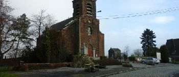
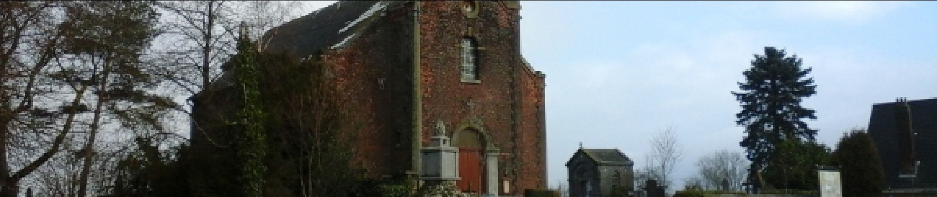
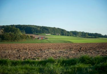
Aulnois, Cantine, Pétrieux, Liessart, Torelies, Rigaux, Montreau, Wanterie, Lassus, Préau... cette balade familiale nous offre à découvrir, sur un parcours relativement restreint, un concentré exceptionnel de fermes ou de « censes » aussi remarquables les unes que les autres. Avec la grotte Notre-Dame de Lourdes, les chapelles du Dieu d’Arras, Saint Expédit, de la Sainte-Famille , Notre-Dame de Bonsecours... ou encore la fontaine Saint-Hilaire (aux vertus curatives, selon la légende), le petit patrimoine religieux n’est pas en reste.
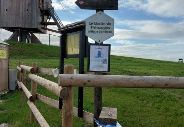
Départ: Place de Thimougies
Balisage: Losange vert
Plus de détails sur:http://www.visitwapi.be/
Plaatsbepaling
Opmerkingen
Wandeltochten in de omgeving
![Tocht Stappen Frasnes-lez-Anvaing - Wapi 2.22 - Balade du](https://media.geolcdn.com/t/375/260/0bed65af-f238-4675-b618-450df0465c65.jpg&format=jpg&maxdim=2)
![Stappen Stappen](https://static1.geolcdn.com/sitytour/trail-icons/101.png)
Stappen
![](/images/other/stat-length.png)
![](https://static1.geolcdn.com/siteimages/upload/files/16400158638029165_repeat_loop_refresh_sync_direction_icon.png)
![Tocht Stappen Doornik - Balade à Thimougies - Promenade de la Croix de la Grise - Photo](https://media.geolcdn.com/t/375/260/4c698c66-ba41-481f-bd5a-416db4e961f5.jpg&format=jpg&maxdim=2)
![Stappen Stappen](https://static1.geolcdn.com/sitytour/trail-icons/101.png)
Stappen
![](/images/other/stat-length.png)
![](https://static1.geolcdn.com/siteimages/upload/files/16400158638029165_repeat_loop_refresh_sync_direction_icon.png)
![Tocht Te voet Frasnes-lez-Anvaing - Wandeling van de ‘Trou Robin’ - Photo](https://media.geolcdn.com/t/375/260/ext.jpg?maxdim=2&url=https%3A%2F%2Fpivotmedia.tourismewallonie.be%2FANX-02-04JL-015N%2FANX-02-04JL-015N.jpg)
![Te voet Te voet](https://static1.geolcdn.com/sitytour/trail-icons/100.png)
Te voet
![](/images/other/stat-length.png)
![](https://static1.geolcdn.com/siteimages/upload/files/16400158638029165_repeat_loop_refresh_sync_direction_icon.png)
![Tocht Te voet Doornik - Boerderijenwandeling - Photo](https://media.geolcdn.com/t/375/260/ext.jpg?maxdim=2&url=https%3A%2F%2Fpivotmedia.tourismewallonie.be%2FANX-02-04OL-0020%2FANX-02-04OL-0020.JPG)
![Te voet Te voet](https://static1.geolcdn.com/sitytour/trail-icons/100.png)
Te voet
![](/images/other/stat-length.png)
![](https://static1.geolcdn.com/siteimages/upload/files/16400158638029165_repeat_loop_refresh_sync_direction_icon.png)
![Tocht Te voet Doornik - Wandeling van](https://media.geolcdn.com/t/375/260/ext.jpg?maxdim=2&url=https%3A%2F%2Fpivotmedia.tourismewallonie.be%2FANX-02-03VU-01FQ%2FANX-02-03VU-01FQ.jpg)
![Te voet Te voet](https://static1.geolcdn.com/sitytour/trail-icons/100.png)
Te voet
![](/images/other/stat-length.png)
![](https://static1.geolcdn.com/siteimages/upload/files/16400158638029165_repeat_loop_refresh_sync_direction_icon.png)
![Tocht Te voet Doornik - Kapelletjes-wandeling - Photo](https://media.geolcdn.com/t/375/260/ext.jpg?maxdim=2&url=https%3A%2F%2Fpivotmedia.tourismewallonie.be%2FANX-02-04OH-006X%2FANX-02-04OH-006X.JPG)
![Te voet Te voet](https://static1.geolcdn.com/sitytour/trail-icons/100.png)
Te voet
![](/images/other/stat-length.png)
![](https://static1.geolcdn.com/siteimages/upload/files/16400158638029165_repeat_loop_refresh_sync_direction_icon.png)
![Tocht Te voet Doornik - Wandeling van](https://media.geolcdn.com/t/375/260/ext.jpg?maxdim=2&url=https%3A%2F%2Fpivotmedia.tourismewallonie.be%2FANX-02-04OI-004Y%2FANX-02-04OI-004Y.JPG)
![Te voet Te voet](https://static1.geolcdn.com/sitytour/trail-icons/100.png)
Te voet
![](/images/other/stat-length.png)
![](https://static1.geolcdn.com/siteimages/upload/files/16400158638029165_repeat_loop_refresh_sync_direction_icon.png)
![Tocht Stappen Doornik - THIMOUGIES _ Marche Adeps _ HT _1/11/2022 - Photo](https://media.geolcdn.com/t/375/260/bd45980c-c924-476b-84f7-03732067fd0b.jpg&format=jpg&maxdim=2)
![Stappen Stappen](https://static1.geolcdn.com/sitytour/trail-icons/101.png)
Stappen
![](/images/other/stat-length.png)
![](https://static1.geolcdn.com/siteimages/upload/files/16400158638029165_repeat_loop_refresh_sync_direction_icon.png)
![Tocht Te voet Doornik - Molenwandeling - Photo](https://media.geolcdn.com/t/375/260/ext.jpg?maxdim=2&url=https%3A%2F%2Fpivotmedia.tourismewallonie.be%2FOTH-A0-005M-08ZT%2FOTH-A0-005M-08ZT.jpg)
![Te voet Te voet](https://static1.geolcdn.com/sitytour/trail-icons/100.png)
Te voet
![](/images/other/stat-length.png)
![](https://static1.geolcdn.com/siteimages/upload/files/16400158638029165_repeat_loop_refresh_sync_direction_icon.png)