![](/images/other/stat-length.png)
![Tocht Stappen Bussang - les neufs bois depuis la Bouloie - Photo](https://media.geolcdn.com/t/1900/400/65153478-b83e-4c04-a96b-40d3c70e551a.jpg&format=pjpeg&maxdim=2)
les neufs bois depuis la Bouloie
margotte
Gebruiker
![Lengte](/images/other/stat-length.png)
Lengte
13,1 km
![Max. hoogte](https://static1.geolcdn.com/siteimages/upload/files/1508320355ic_sort_altitude_max_24dp.png)
Max. hoogte
1139 m
![Positief hoogteverschil](https://static1.geolcdn.com/siteimages/upload/files/1508320355ic_sort_den_pos_24dp.png)
Positief hoogteverschil
556 m
![Km-Effort](/images/other/stat-length.png)
Km-Effort
21 km
![Min. hoogte](https://static1.geolcdn.com/siteimages/upload/files/1508320355ic_sort_altitude_min_24dp.png)
Min. hoogte
866 m
![Negatief hoogteverschil](https://static1.geolcdn.com/siteimages/upload/files/1508320355ic_sort_den_neg_24dp.png)
Negatief hoogteverschil
556 m
![Boucle](https://static1.geolcdn.com/siteimages/upload/files/16400158638029165_repeat_loop_refresh_sync_direction_icon.png)
Boucle
Ja
Datum van aanmaak :
2020-09-03 08:01:44.85
Laatste wijziging :
2020-09-03 17:26:26.922
![Stappen](https://static1.geolcdn.com/sitytour/trail-icons/101.png)
3h13
Moeilijkheid : Medium
![Scan deze QR-code om de tocht te openen in de SityTrail-applicatie](https://capi.geolives.com/qq0zvz2zws4bq2lad0pu/sitytour/trails/2536509/qr.png?size=200)
Gratisgps-wandelapplicatie
Over ons
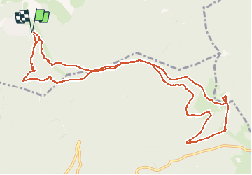
Tocht Stappen van 13,1 km beschikbaar op Grand Est, Vogezen, Bussang. Deze tocht wordt voorgesteld door margotte.
Beschrijving
De la forêt de l'étage montagnard à la chaume secondaire (défrichement dû à l'action humaine) en passant par 3 etangs et une tourbière, les vestiges des dernières guerres, le parcours est super intéressant .
Plaatsbepaling
Land:
France
Regio :
Grand Est
Departement/Provincie :
Vogezen
Gemeente :
Bussang
Locatie:
Unknown
Vertrek:(Dec)
Vertrek:(UTM)
340154 ; 5304654 (32T) N.
Opmerkingen
Wandeltochten in de omgeving
![Tocht Stappen Bussang - Col de Bussang - Rouge Gazon - Séchenat - Photo](https://media.geolcdn.com/t/375/260/ext.jpg?maxdim=2&url=https%3A%2F%2Fservices.sitytrail.com%2FGeolivesWS%2FDownloadMedia.ashx%3FTrailID%3D450013%26Media%3Dfix__20150715145430.jpg)
![Stappen Stappen](https://static1.geolcdn.com/sitytour/trail-icons/101.png)
Col de Bussang - Rouge Gazon - Séchenat
Stappen
Moeilijk
(1)
Bussang,
Grand Est,
Vogezen,
France
![](/images/other/stat-length.png)
15 km | 24 km-effort
6h 0min
![](https://static1.geolcdn.com/siteimages/upload/files/16400158638029165_repeat_loop_refresh_sync_direction_icon.png)
Neen
![Tocht Stappen Saint-Maurice-sur-Moselle - Tour du Ballon d'Alsace - Photo](https://media.geolcdn.com/t/375/260/ext.jpg?maxdim=2&url=https%3A%2F%2Fservices.sitytrail.com%2FGeolivesWS%2FDownloadMedia.ashx%3FTrailID%3D450011%26Media%3Dfix__20150716161020.jpg)
![Stappen Stappen](https://static1.geolcdn.com/sitytour/trail-icons/101.png)
Tour du Ballon d'Alsace
Stappen
Moeilijk
(1)
Saint-Maurice-sur-Moselle,
Grand Est,
Vogezen,
France
![](/images/other/stat-length.png)
10,5 km | 17,7 km-effort
5h 25min
![](https://static1.geolcdn.com/siteimages/upload/files/16400158638029165_repeat_loop_refresh_sync_direction_icon.png)
Ja
![Tocht Sneeuwschoenen Bussang - Circuit de raquette de Bussang - Photo](https://media.geolcdn.com/t/375/260/ext.jpg?maxdim=2&url=https%3A%2F%2Fservices.sitytrail.com%2FGeolivesWS%2FDownloadMedia.ashx%3FTrailID%3D111638%26Media%3D7873_6.jpg)
![Sneeuwschoenen Sneeuwschoenen](https://static1.geolcdn.com/sitytour/trail-icons/504.png)
Circuit de raquette de Bussang
Sneeuwschoenen
Moeilijk
(1)
Bussang,
Grand Est,
Vogezen,
France
![](/images/other/stat-length.png)
7,7 km | 11,2 km-effort
3h 0min
![](https://static1.geolcdn.com/siteimages/upload/files/16400158638029165_repeat_loop_refresh_sync_direction_icon.png)
Ja
![Tocht Stappen Storckensohn - lac des perches marchettes - Photo](https://media.geolcdn.com/t/375/260/ba8e93c4-c66a-48b1-88b8-cca79cc3effc.jpg&format=jpg&maxdim=2)
![Stappen Stappen](https://static1.geolcdn.com/sitytour/trail-icons/101.png)
lac des perches marchettes
Stappen
Medium
(1)
Storckensohn,
Grand Est,
Haut-Rhin,
France
![](/images/other/stat-length.png)
11,9 km | 20 km-effort
4h 8min
![](https://static1.geolcdn.com/siteimages/upload/files/16400158638029165_repeat_loop_refresh_sync_direction_icon.png)
Ja
![Mountainbike Mountainbike](https://static1.geolcdn.com/sitytour/trail-icons/202.png)
SityTrail - 3248441 - documentxix745004916x3256137
Mountainbike
Medium
Saint-Maurice-sur-Moselle,
Grand Est,
Vogezen,
France
![](/images/other/stat-length.png)
21 km | 30 km-effort
2h 3min
![](https://static1.geolcdn.com/siteimages/upload/files/16400158638029165_repeat_loop_refresh_sync_direction_icon.png)
Ja
![Mountainbike Mountainbike](https://static1.geolcdn.com/sitytour/trail-icons/202.png)
activity_9407679223
Mountainbike
Medium
Bussang,
Grand Est,
Vogezen,
France
![](/images/other/stat-length.png)
21 km | 30 km-effort
2h 2min
![](https://static1.geolcdn.com/siteimages/upload/files/16400158638029165_repeat_loop_refresh_sync_direction_icon.png)
Ja
![Tocht Stappen Storckensohn - 2022-07-16 Marche Auberge Gazon Vert Chapelle des Ves - Photo](https://media.geolcdn.com/t/375/260/7aac2105-88e6-44f1-a6d0-d41240d9f4c5.jpg&format=jpg&maxdim=2)
![Stappen Stappen](https://static1.geolcdn.com/sitytour/trail-icons/101.png)
2022-07-16 Marche Auberge Gazon Vert Chapelle des Ves
Stappen
Zeer moeilijk
Storckensohn,
Grand Est,
Haut-Rhin,
France
![](/images/other/stat-length.png)
21 km | 37 km-effort
6h 11min
![](https://static1.geolcdn.com/siteimages/upload/files/16400158638029165_repeat_loop_refresh_sync_direction_icon.png)
Neen
![Tocht Te voet Ventron - Circuit de la Croix de l’Hermite par Forgoutte - Photo](https://media.geolcdn.com/t/375/260/d9c2017f-89af-4e26-9799-43d15f74a50f.jpeg&format=jpg&maxdim=2)
![Te voet Te voet](https://static1.geolcdn.com/sitytour/trail-icons/100.png)
Circuit de la Croix de l’Hermite par Forgoutte
Te voet
Gemakkelijk
Ventron,
Grand Est,
Vogezen,
France
![](/images/other/stat-length.png)
4,3 km | 6,6 km-effort
1h 29min
![](https://static1.geolcdn.com/siteimages/upload/files/16400158638029165_repeat_loop_refresh_sync_direction_icon.png)
Neen
![Mountainbike Mountainbike](https://static1.geolcdn.com/sitytour/trail-icons/202.png)
Bussang_20210918_101006
Mountainbike
Heel gemakkelijk
Bussang,
Grand Est,
Vogezen,
France
![](/images/other/stat-length.png)
30 km | 43 km-effort
Onbekend
![](https://static1.geolcdn.com/siteimages/upload/files/16400158638029165_repeat_loop_refresh_sync_direction_icon.png)
Neen