![](/images/other/stat-length.png)
![Tocht Stappen Villeneuve-de-Marsan - Villeneuve, le midou. trace faite - Photo](https://media.geolcdn.com/t/1900/400/ext.pjpeg?maxdim=2&url=https%3A%2F%2Fstatic1.geolcdn.com%2Fsiteimages%2Fupload%2Ffiles%2F1553511878bg_sport_marche.png)
Villeneuve, le midou. trace faite
papiou
Gebruiker
![Lengte](/images/other/stat-length.png)
Lengte
7,6 km
![Max. hoogte](https://static1.geolcdn.com/siteimages/upload/files/1508320355ic_sort_altitude_max_24dp.png)
Max. hoogte
91 m
![Positief hoogteverschil](https://static1.geolcdn.com/siteimages/upload/files/1508320355ic_sort_den_pos_24dp.png)
Positief hoogteverschil
87 m
![Km-Effort](/images/other/stat-length.png)
Km-Effort
8,7 km
![Min. hoogte](https://static1.geolcdn.com/siteimages/upload/files/1508320355ic_sort_altitude_min_24dp.png)
Min. hoogte
55 m
![Negatief hoogteverschil](https://static1.geolcdn.com/siteimages/upload/files/1508320355ic_sort_den_neg_24dp.png)
Negatief hoogteverschil
87 m
![Boucle](https://static1.geolcdn.com/siteimages/upload/files/16400158638029165_repeat_loop_refresh_sync_direction_icon.png)
Boucle
Ja
Datum van aanmaak :
2020-09-01 07:10:41.035
Laatste wijziging :
2020-09-01 09:04:54.857
![Stappen](https://static1.geolcdn.com/sitytour/trail-icons/101.png)
1h34
Moeilijkheid : Gemakkelijk
![Scan deze QR-code om de tocht te openen in de SityTrail-applicatie](https://capi.geolives.com/qq0zvz2zws4bq2lad0pu/sitytour/trails/2534271/qr.png?size=200)
Gratisgps-wandelapplicatie
Over ons
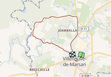
Tocht Stappen van 7,6 km beschikbaar op Nieuw-Aquitanië, Landes, Villeneuve-de-Marsan. Deze tocht wordt voorgesteld door papiou.
Beschrijving
comme nombre de randos dans les Landes, beaucoup de macadam avec à la fin du circuit CD dangereux. rdv sur la place et dos au tableau du descriptif de la rando prendre la rue à droite et suivre itinéraire. belle randonnée toutefois
Plaatsbepaling
Land:
France
Regio :
Nieuw-Aquitanië
Departement/Provincie :
Landes
Gemeente :
Villeneuve-de-Marsan
Locatie:
Unknown
Vertrek:(Dec)
Vertrek:(UTM)
716546 ; 4863389 (30T) N.
Opmerkingen
Wandeltochten in de omgeving
![Tocht Stappen Arthez-d'Armagnac - arthez d'Armagnac, circuit d'ognias - Photo](https://media.geolcdn.com/t/375/260/5c24c389-4b2e-42df-82c1-d090e8b58cd7.jpg&format=jpg&maxdim=2)
![Stappen Stappen](https://static1.geolcdn.com/sitytour/trail-icons/101.png)
arthez d'Armagnac, circuit d'ognias
Stappen
Medium
Arthez-d'Armagnac,
Nieuw-Aquitanië,
Landes,
France
![](/images/other/stat-length.png)
10,4 km | 12,4 km-effort
2h 53min
![](https://static1.geolcdn.com/siteimages/upload/files/16400158638029165_repeat_loop_refresh_sync_direction_icon.png)
Ja
![Tocht Te voet Villeneuve-de-Marsan - Petite Randonnée Villeneuve - Photo](https://media.geolcdn.com/t/375/260/9a1502fb-95da-4a41-b70c-7efd1ad3de51.jpeg&format=jpg&maxdim=2)
![Te voet Te voet](https://static1.geolcdn.com/sitytour/trail-icons/100.png)
Petite Randonnée Villeneuve
Te voet
Gemakkelijk
Villeneuve-de-Marsan,
Nieuw-Aquitanië,
Landes,
France
![](/images/other/stat-length.png)
6,1 km | 7,1 km-effort
1h 36min
![](https://static1.geolcdn.com/siteimages/upload/files/16400158638029165_repeat_loop_refresh_sync_direction_icon.png)
Ja
![Tocht Stappen Pujo-le-Plan - autour de Pujo le Plan - Photo](https://media.geolcdn.com/t/375/260/ext.jpg?maxdim=2&url=https%3A%2F%2Fstatic1.geolcdn.com%2Fsiteimages%2Fupload%2Ffiles%2F1553511878bg_sport_marche.png)
![Stappen Stappen](https://static1.geolcdn.com/sitytour/trail-icons/101.png)
autour de Pujo le Plan
Stappen
Medium
Pujo-le-Plan,
Nieuw-Aquitanië,
Landes,
France
![](/images/other/stat-length.png)
12,9 km | 14,7 km-effort
2h 40min
![](https://static1.geolcdn.com/siteimages/upload/files/16400158638029165_repeat_loop_refresh_sync_direction_icon.png)
Ja
![Tocht Andere activiteiten Perquie - Isabelle - Photo](https://media.geolcdn.com/t/375/260/ext.jpg?maxdim=2&url=https%3A%2F%2Fstatic1.geolcdn.com%2Fsiteimages%2Fupload%2Ffiles%2F1545311037marcheuse_200dpi.jpg)
![Andere activiteiten Andere activiteiten](https://static1.geolcdn.com/sitytour/trail-icons/900.png)
Isabelle
Andere activiteiten
Heel gemakkelijk
Perquie,
Nieuw-Aquitanië,
Landes,
France
![](/images/other/stat-length.png)
8,9 km | 10,5 km-effort
1h 27min
![](https://static1.geolcdn.com/siteimages/upload/files/16400158638029165_repeat_loop_refresh_sync_direction_icon.png)
Ja
![Tocht Stappen Gaillères - Circuit des Airials Gaillères - Photo](https://media.geolcdn.com/t/375/260/ext.jpg?maxdim=2&url=https%3A%2F%2Fstatic1.geolcdn.com%2Fsiteimages%2Fupload%2Ffiles%2F1553511878bg_sport_marche.png)
![Stappen Stappen](https://static1.geolcdn.com/sitytour/trail-icons/101.png)
Circuit des Airials Gaillères
Stappen
Heel gemakkelijk
Gaillères,
Nieuw-Aquitanië,
Landes,
France
![](/images/other/stat-length.png)
6,5 km | 7,4 km-effort
2h 17min
![](https://static1.geolcdn.com/siteimages/upload/files/16400158638029165_repeat_loop_refresh_sync_direction_icon.png)
Ja
![Tocht Stappen Gaillères - Etangs de Gaillères - Photo](https://media.geolcdn.com/t/375/260/ext.jpg?maxdim=2&url=https%3A%2F%2Fstatic1.geolcdn.com%2Fsiteimages%2Fupload%2Ffiles%2F1553511878bg_sport_marche.png)
![Stappen Stappen](https://static1.geolcdn.com/sitytour/trail-icons/101.png)
Etangs de Gaillères
Stappen
Heel gemakkelijk
Gaillères,
Nieuw-Aquitanië,
Landes,
France
![](/images/other/stat-length.png)
6,9 km | 7,9 km-effort
1h 23min
![](https://static1.geolcdn.com/siteimages/upload/files/16400158638029165_repeat_loop_refresh_sync_direction_icon.png)
Ja
![Tocht Fietstoerisme Villeneuve-de-Marsan - Villeneuve de Marsan - Circuit de l'Armagnac - Photo](https://media.geolcdn.com/t/375/260/ext.jpg?maxdim=2&url=https%3A%2F%2Fstatic1.geolcdn.com%2Fsiteimages%2Fupload%2Ffiles%2F1524743154velo.jpg)
![Fietstoerisme Fietstoerisme](https://static1.geolcdn.com/sitytour/trail-icons/204.png)
Villeneuve de Marsan - Circuit de l'Armagnac
Fietstoerisme
Medium
Villeneuve-de-Marsan,
Nieuw-Aquitanië,
Landes,
France
![](/images/other/stat-length.png)
63 km | 72 km-effort
Onbekend
![](https://static1.geolcdn.com/siteimages/upload/files/16400158638029165_repeat_loop_refresh_sync_direction_icon.png)
Ja
![Tocht Stappen Villeneuve-de-Marsan - le midou, Villeneuve de Marsan (variante) - Photo](https://media.geolcdn.com/t/375/260/ext.jpg?maxdim=2&url=https%3A%2F%2Fstatic1.geolcdn.com%2Fsiteimages%2Fupload%2Ffiles%2F1553511878bg_sport_marche.png)
![Stappen Stappen](https://static1.geolcdn.com/sitytour/trail-icons/101.png)
le midou, Villeneuve de Marsan (variante)
Stappen
Medium
Villeneuve-de-Marsan,
Nieuw-Aquitanië,
Landes,
France
![](/images/other/stat-length.png)
7,1 km | 8,2 km-effort
1h 53min
![](https://static1.geolcdn.com/siteimages/upload/files/16400158638029165_repeat_loop_refresh_sync_direction_icon.png)
Ja