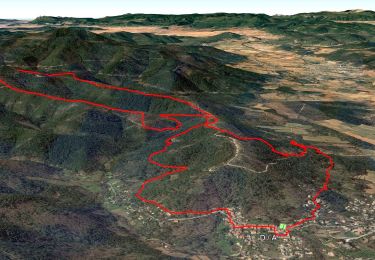
![](/images/other/stat-length.png)
![Tocht Stappen Le Cannet-des-Maures - lac des Escarcets - Photo](https://media.geolcdn.com/t/1900/400/74e2ec93-d1c5-4e67-b4d9-ec0797e448ae.jpg&format=pjpeg&maxdim=2)
lac des Escarcets
LBarel
Gebruiker
![Lengte](/images/other/stat-length.png)
![Max. hoogte](https://static1.geolcdn.com/siteimages/upload/files/1508320355ic_sort_altitude_max_24dp.png)
![Positief hoogteverschil](https://static1.geolcdn.com/siteimages/upload/files/1508320355ic_sort_den_pos_24dp.png)
![Km-Effort](/images/other/stat-length.png)
![Min. hoogte](https://static1.geolcdn.com/siteimages/upload/files/1508320355ic_sort_altitude_min_24dp.png)
![Negatief hoogteverschil](https://static1.geolcdn.com/siteimages/upload/files/1508320355ic_sort_den_neg_24dp.png)
![Boucle](https://static1.geolcdn.com/siteimages/upload/files/16400158638029165_repeat_loop_refresh_sync_direction_icon.png)
![Stappen](https://static1.geolcdn.com/sitytour/trail-icons/101.png)
2h59
Moeilijkheid : Heel gemakkelijk
![Scan deze QR-code om de tocht te openen in de SityTrail-applicatie](https://capi.geolives.com/qq0zvz2zws4bq2lad0pu/sitytour/trails/2530927/qr.png?size=200)
Gratisgps-wandelapplicatie
Over ons
Tocht Stappen van 8,6 km beschikbaar op Provence-Alpes-Côte d'Azur, Var, Le Cannet-des-Maures. Deze tocht wordt voorgesteld door LBarel.
Beschrijving
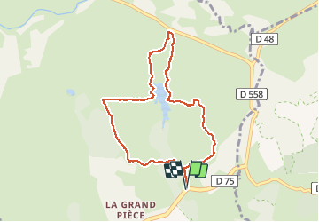
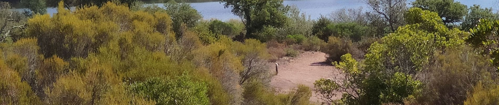
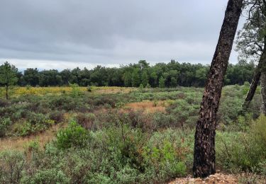
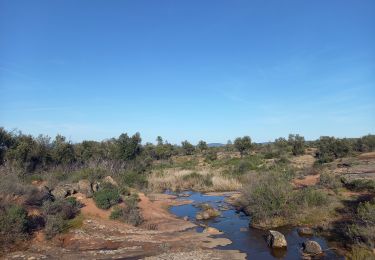
Une promenade sans difficultés, souvent ceinturée par des "haies" électrifiées permettant la régénération de la faune et le flore, derrière lesquelles des ânes nous ont accompagnés un temps. Passé le lac et sur le retour à l'Est, la rumeur de la D558 domine la nature...
Une balade sans trop d'ombrage, à anticiper par grand soleil.
Plaatsbepaling
Opmerkingen
Wandeltochten in de omgeving
![Tocht Stappen Les Mayons - FFRandonnée-Sur_les_traces_du_decauville - Photo](https://media.geolcdn.com/t/375/260/bcb1604c-22f0-433d-9ea7-43bb42cd787e.jpg&format=jpg&maxdim=2)
![Stappen Stappen](https://static1.geolcdn.com/sitytour/trail-icons/101.png)
Stappen
![](/images/other/stat-length.png)
![](https://static1.geolcdn.com/siteimages/upload/files/16400158638029165_repeat_loop_refresh_sync_direction_icon.png)
![Tocht Stappen La Garde-Freinet - SityTrail - Fort Freinet-la Garde-Freinet-02-06-23 - Photo](https://media.geolcdn.com/t/375/260/ce777452-e991-4230-8a3a-fe54e13fa23c.jpg&format=jpg&maxdim=2)
![Stappen Stappen](https://static1.geolcdn.com/sitytour/trail-icons/101.png)
Stappen
![](/images/other/stat-length.png)
![](https://static1.geolcdn.com/siteimages/upload/files/16400158638029165_repeat_loop_refresh_sync_direction_icon.png)
![Tocht Stappen Les Mayons - Sur les hauteurs des Mayons - Photo](https://media.geolcdn.com/t/375/260/a3854856-9a5e-4079-97cc-abf551e29f44.jpg&format=jpg&maxdim=2)
![Stappen Stappen](https://static1.geolcdn.com/sitytour/trail-icons/101.png)
Stappen
![](/images/other/stat-length.png)
![](https://static1.geolcdn.com/siteimages/upload/files/16400158638029165_repeat_loop_refresh_sync_direction_icon.png)
![Tocht Stappen Le Cannet-des-Maures - Palne des Maures - Photo](https://media.geolcdn.com/t/375/260/ext.jpg?maxdim=2&url=https%3A%2F%2Fservices.sitytrail.com%2FGeolivesWS%2FDownloadMedia.ashx%3FTrailID%3D844726%26Media%3D68613b80-dcb5-4229-b6f3-c522275e4d7f.JPG)
![Stappen Stappen](https://static1.geolcdn.com/sitytour/trail-icons/101.png)
Stappen
![](/images/other/stat-length.png)
![](https://static1.geolcdn.com/siteimages/upload/files/16400158638029165_repeat_loop_refresh_sync_direction_icon.png)
![Tocht Stappen Le Cannet-des-Maures - lac des escarcets - Photo](https://media.geolcdn.com/t/375/260/ext.jpg?maxdim=2&url=https%3A%2F%2Fstatic1.geolcdn.com%2Fsiteimages%2Fupload%2Ffiles%2F1553511878bg_sport_marche.png)
![Stappen Stappen](https://static1.geolcdn.com/sitytour/trail-icons/101.png)
Stappen
![](/images/other/stat-length.png)
![](https://static1.geolcdn.com/siteimages/upload/files/16400158638029165_repeat_loop_refresh_sync_direction_icon.png)
![Tocht Stappen Le Cannet-des-Maures - Autour de](https://media.geolcdn.com/t/375/260/3960aebc-118c-48a0-9a3c-97208858bc15.jpg&format=jpg&maxdim=2)
![Stappen Stappen](https://static1.geolcdn.com/sitytour/trail-icons/101.png)
Stappen
![](/images/other/stat-length.png)
![](https://static1.geolcdn.com/siteimages/upload/files/16400158638029165_repeat_loop_refresh_sync_direction_icon.png)
![Tocht Stappen La Garde-Freinet - La Mourre, La Garde-Freinet-22-05-24 - Photo](https://media.geolcdn.com/t/375/260/d83ec998-34f1-4f9a-9ad9-3f2fca5f6ed5.jpg&format=jpg&maxdim=2)
![Stappen Stappen](https://static1.geolcdn.com/sitytour/trail-icons/101.png)
Stappen
![](/images/other/stat-length.png)
![](https://static1.geolcdn.com/siteimages/upload/files/16400158638029165_repeat_loop_refresh_sync_direction_icon.png)
![Tocht Stappen Les Mayons - Les Mayons - le Castel des Maures - Photo](https://media.geolcdn.com/t/375/260/a47ad560-13ae-4c6e-9e30-50d56076ccfc.jpg&format=jpg&maxdim=2)
![Stappen Stappen](https://static1.geolcdn.com/sitytour/trail-icons/101.png)
Stappen
![](/images/other/stat-length.png)
![](https://static1.geolcdn.com/siteimages/upload/files/16400158638029165_repeat_loop_refresh_sync_direction_icon.png)
![Tocht Stappen Le Cannet-des-Maures - Lac des Escarcets 17.2.24 - Photo](https://media.geolcdn.com/t/375/260/f92ce486-bd5f-4ab3-9b40-d60a411549dd.jpg&format=jpg&maxdim=2)
![Stappen Stappen](https://static1.geolcdn.com/sitytour/trail-icons/101.png)
Stappen
![](/images/other/stat-length.png)
![](https://static1.geolcdn.com/siteimages/upload/files/16400158638029165_repeat_loop_refresh_sync_direction_icon.png)