Tocht Stappen Saint-Christophe-sur-Roc - 79 SAINT CHRISTOPHE SUR ROC  Montplaisir Phlé Chilou et Le Breuil - Photo

79 SAINT CHRISTOPHE SUR ROC Montplaisir Phlé Chilou et Le Breuil

 maioy
maioy

Gebruiker

© OpenStreetMap contributors
Lengte
Lengte
8,7 km
Max. hoogte
Max. hoogte
135 m
Positief hoogteverschil
97 m
Km-Effort
Km-Effort  
10 km
Min. hoogte
Min. hoogte
96 m
Negatief hoogteverschil
97 m
Boucle
Boucle
Ja
Datum van aanmaak :
2020-08-28 15:57:17.092
Laatste wijziging :
2020-08-28 15:59:45.765

(0 Bericht)

Stappen
Stappen
2h11
Moeilijkheid : Medium

Scan deze QR-code om de tocht te openen in de SityTrail-applicatie

Gratisgps-wandelapplicatie

Logo SityTrail SityTrail

IGN / Geografische instituten

SityTrail uit de App Store downloaden SityTrail uit Google Play downloaden

Logo SityTrail SityTrail World

De wereld gaat voor u open

SityTrail uit de App Store downloaden SityTrail uit Google Play downloaden SityTrail op Huawei AppGallery downloaden

Over ons

Tocht Stappen van 8,7 km beschikbaar op Nieuw-Aquitanië, Deux-Sèvres, Saint-Christophe-sur-Roc. Deze tocht wordt voorgesteld door maioy.

Hoogteprofiel

Plaatsbepaling

Land:
France
Regio :
Nieuw-Aquitanië
Departement/Provincie :
Deux-Sèvres
Gemeente :
Saint-Christophe-sur-Roc
Locatie:
Unknown
Vertrek:(UTM)
701962 ; 5149229 (30T) N.

Wandeltochten in de omgeving

Tocht Paardrijden Champdeniers - Rando de l' Autize 27 raccourci - Photo
Paardrijden
Dom4i

Paardrijden

Medium
(1)
Champdeniers, Nieuw-Aquitanië, Deux-Sèvres, France
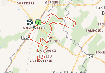
22 km | 27 km-effort
3h 32min
Ja
Tocht Paardrijden Augé - Bois Aigu Clavé 2 - Photo
Paardrijden
Dom4i

Paardrijden

Zeer moeilijk
(1)
Augé, Nieuw-Aquitanië, Deux-Sèvres, France
40 km | 50 km-effort
6h 32min
Ja
Tocht Stappen Germond-Rouvre - 2020-09-19  - Photo
Stappen
cagouille79

Stappen

Medium
Germond-Rouvre, Nieuw-Aquitanië, Deux-Sèvres, France
12,9 km | 16,2 km-effort
2h 59min
Ja
Tocht Stappen Saint-Christophe-sur-Roc - St Christophe sur Roc - Photo
Stappen
olaze

Stappen

Gemakkelijk
Saint-Christophe-sur-Roc, Nieuw-Aquitanië, Deux-Sèvres, France
10,9 km | 13 km-effort
2h 49min
Ja
Tocht Stappen Champdeniers - Champeaux - Photo
Stappen
olaze

Stappen

Gemakkelijk
Champdeniers, Nieuw-Aquitanië, Deux-Sèvres, France
8,1 km | 9,8 km-effort
2h 8min
Ja
Tocht Stappen Mazières-en-Gâtine - Mazières-en-Gâtine Golf - Photo
Stappen
Philippe Baraton

Stappen

Heel gemakkelijk
Mazières-en-Gâtine, Nieuw-Aquitanië, Deux-Sèvres, France
9,4 km | 10,9 km-effort
2h 10min
Ja
Tocht Quad Cours - cours - Photo
Quad
GLOAGUEN FABRICE

Quad

Heel gemakkelijk
Cours, Nieuw-Aquitanië, Deux-Sèvres, France
73 km | 87 km-effort
3h 49min
Ja
Tocht Quad Cours - cours augé saint georges - Photo
Quad
Antoine 85200

Quad

Heel gemakkelijk
Cours, Nieuw-Aquitanië, Deux-Sèvres, France
74 km | 88 km-effort
4h 20min
Ja
Tocht Stappen Champdeniers - Barbaudière  - Photo
Stappen
clhote

Stappen

Medium
Champdeniers, Nieuw-Aquitanië, Deux-Sèvres, France
9,6 km | 11 km-effort
2h 26min
Ja


Sluiten
Mijn abonnementen