![](/images/other/stat-length.png)
![Tocht Stappen Pont-les-Moulins - pont les moulins - Photo](https://media.geolcdn.com/t/1900/400/7e6122b6-1654-426d-8833-6b2b329e62b0.jpg&format=pjpeg&maxdim=2)
pont les moulins
eltonnermou
Gebruiker
![Lengte](/images/other/stat-length.png)
![Max. hoogte](https://static1.geolcdn.com/siteimages/upload/files/1508320355ic_sort_altitude_max_24dp.png)
![Positief hoogteverschil](https://static1.geolcdn.com/siteimages/upload/files/1508320355ic_sort_den_pos_24dp.png)
![Km-Effort](/images/other/stat-length.png)
![Min. hoogte](https://static1.geolcdn.com/siteimages/upload/files/1508320355ic_sort_altitude_min_24dp.png)
![Negatief hoogteverschil](https://static1.geolcdn.com/siteimages/upload/files/1508320355ic_sort_den_neg_24dp.png)
![Boucle](https://static1.geolcdn.com/siteimages/upload/files/16400158638029165_repeat_loop_refresh_sync_direction_icon.png)
![Stappen](https://static1.geolcdn.com/sitytour/trail-icons/101.png)
2h49
Moeilijkheid : Gemakkelijk
![Scan deze QR-code om de tocht te openen in de SityTrail-applicatie](https://capi.geolives.com/qq0zvz2zws4bq2lad0pu/sitytour/trails/2529217/qr.png?size=200)
Gratisgps-wandelapplicatie
Over ons
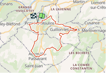
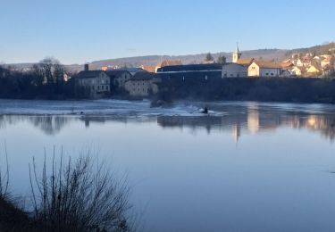
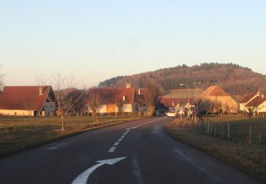
Tocht Stappen van 16,8 km beschikbaar op Bourgondië-Franche-Comté, Doubs, Pont-les-Moulins. Deze tocht wordt voorgesteld door eltonnermou.
Beschrijving
16.8km ; 452m dénivelé
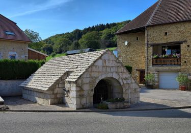
parking du cimetière (dir Villers st martin). une salle repas tiré du sac à 13km (du départ). bâtons conseillés pour la dernière descente sur Pont les Moulins.
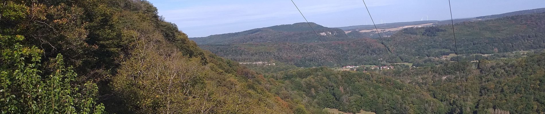
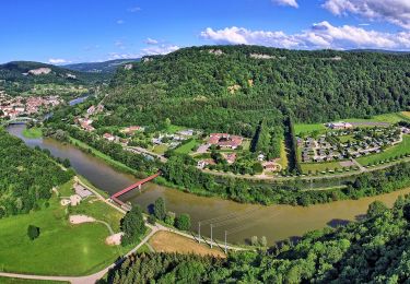
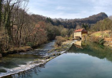
Une belle randonnée facile d'accès tout au long, à travers la campagne comtoise. De beaux points de vue depuis les hauteurs. Aucune montée difficile, beaucoup de sous-bois. Seul petit bémol les 5,5km de goudron sur de toutes petites routes très tranquilles.
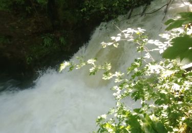
Avec un peu de chance, vous surprendrez des chamois sur les pentes escarpées du secteur. Vous pourrez apprécier la diversité de la flore.
Plaatsbepaling
Opmerkingen
Wandeltochten in de omgeving
![Tocht Stappen Villers-Saint-Martin - Villers st Martin](https://media.geolcdn.com/t/375/260/2c6ae54c-f240-47b2-a0d6-247007965cef.jpg&format=jpg&maxdim=2)
![Stappen Stappen](https://static1.geolcdn.com/sitytour/trail-icons/101.png)
Stappen
![](/images/other/stat-length.png)
![](https://static1.geolcdn.com/siteimages/upload/files/16400158638029165_repeat_loop_refresh_sync_direction_icon.png)
![Tocht Stappen Silley-Bléfond - Silley Blėfond - Photo](https://media.geolcdn.com/t/375/260/72cba853-944f-4e71-a6a4-e1015b10675c.jpg&format=jpg&maxdim=2)
![Stappen Stappen](https://static1.geolcdn.com/sitytour/trail-icons/101.png)
Stappen
![](/images/other/stat-length.png)
![](https://static1.geolcdn.com/siteimages/upload/files/16400158638029165_repeat_loop_refresh_sync_direction_icon.png)
![Tocht Te voet Bretigney-Notre-Dame - Les Gorges de l'Audeux - Photo](https://media.geolcdn.com/t/375/260/3c4f074e-3673-45a1-aa6d-0738dd54ea67.jpeg&format=jpg&maxdim=2)
![Te voet Te voet](https://static1.geolcdn.com/sitytour/trail-icons/100.png)
Te voet
![](/images/other/stat-length.png)
![](https://static1.geolcdn.com/siteimages/upload/files/16400158638029165_repeat_loop_refresh_sync_direction_icon.png)
![Tocht Te voet Esnans - Mont Dommage - Photo](https://media.geolcdn.com/t/375/260/79f418a8-7ee1-46f5-8173-ee740f887b5c.jpeg&format=jpg&maxdim=2)
![Te voet Te voet](https://static1.geolcdn.com/sitytour/trail-icons/100.png)
Te voet
![](/images/other/stat-length.png)
![](https://static1.geolcdn.com/siteimages/upload/files/16400158638029165_repeat_loop_refresh_sync_direction_icon.png)
![Tocht Te voet Baume-les-Dames - La Croix de Châtard - Photo](https://media.geolcdn.com/t/375/260/d651c9f5-c262-4fb0-99ee-1d55033f4dec.jpeg&format=jpg&maxdim=2)
![Te voet Te voet](https://static1.geolcdn.com/sitytour/trail-icons/100.png)
Te voet
![](/images/other/stat-length.png)
![](https://static1.geolcdn.com/siteimages/upload/files/16400158638029165_repeat_loop_refresh_sync_direction_icon.png)
![Tocht Te voet Baume-les-Dames - La Fente de Babre - Photo](https://media.geolcdn.com/t/375/260/f4606131-7993-4602-bc5e-c9844fe9a64f.jpeg&format=jpg&maxdim=2)
![Te voet Te voet](https://static1.geolcdn.com/sitytour/trail-icons/100.png)
Te voet
![](/images/other/stat-length.png)
![](https://static1.geolcdn.com/siteimages/upload/files/16400158638029165_repeat_loop_refresh_sync_direction_icon.png)
![Tocht Stappen Baume-les-Dames - Baume les dames, fente de Babre - Photo](https://media.geolcdn.com/t/375/260/aa0af467-9313-4a29-a7b9-19f30e0259cd.jpg&format=jpg&maxdim=2)
![Stappen Stappen](https://static1.geolcdn.com/sitytour/trail-icons/101.png)
Stappen
![](/images/other/stat-length.png)
![](https://static1.geolcdn.com/siteimages/upload/files/16400158638029165_repeat_loop_refresh_sync_direction_icon.png)
![Tocht Te voet Adam-lès-Passavant - Bois de Rodolphe par Adam-lès-Passavant - Photo](https://media.geolcdn.com/t/375/260/1fbddc1c-5aaf-4c1f-8156-64b325a3aa3f.jpeg&format=jpg&maxdim=2)
![Te voet Te voet](https://static1.geolcdn.com/sitytour/trail-icons/100.png)
Te voet
![](/images/other/stat-length.png)
![](https://static1.geolcdn.com/siteimages/upload/files/16400158638029165_repeat_loop_refresh_sync_direction_icon.png)
![Tocht Stappen Baume-les-Dames - BAUMES LES DAMES - Photo](https://media.geolcdn.com/t/375/260/8c1565c0-38e1-4be4-bf1f-af89f519ddec.jpg&format=jpg&maxdim=2)
![Stappen Stappen](https://static1.geolcdn.com/sitytour/trail-icons/101.png)
Stappen
![](/images/other/stat-length.png)
![](https://static1.geolcdn.com/siteimages/upload/files/16400158638029165_repeat_loop_refresh_sync_direction_icon.png)