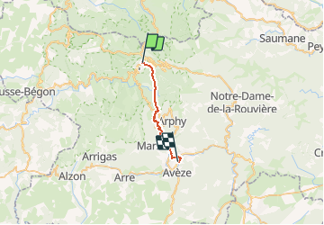
![](/images/other/stat-length.png)
![Tocht Stappen Val-d'Aigoual - Espérou (l') au Vigan 19 370m +283m - Chamina J3 - Photo](https://media.geolcdn.com/t/1900/400/ext.pjpeg?maxdim=2&url=https%3A%2F%2Fstatic1.geolcdn.com%2Fsiteimages%2Fupload%2Ffiles%2F1553511878bg_sport_marche.png)
Espérou (l') au Vigan 19 370m +283m - Chamina J3
DanielROLLET
Gebruiker
![Lengte](/images/other/stat-length.png)
![Max. hoogte](https://static1.geolcdn.com/siteimages/upload/files/1508320355ic_sort_altitude_max_24dp.png)
![Positief hoogteverschil](https://static1.geolcdn.com/siteimages/upload/files/1508320355ic_sort_den_pos_24dp.png)
![Km-Effort](/images/other/stat-length.png)
![Min. hoogte](https://static1.geolcdn.com/siteimages/upload/files/1508320355ic_sort_altitude_min_24dp.png)
![Negatief hoogteverschil](https://static1.geolcdn.com/siteimages/upload/files/1508320355ic_sort_den_neg_24dp.png)
![Boucle](https://static1.geolcdn.com/siteimages/upload/files/16400158638029165_repeat_loop_refresh_sync_direction_icon.png)
![Stappen](https://static1.geolcdn.com/sitytour/trail-icons/101.png)
7h10
Moeilijkheid : Zeer moeilijk
![Scan deze QR-code om de tocht te openen in de SityTrail-applicatie](https://capi.geolives.com/qq0zvz2zws4bq2lad0pu/sitytour/trails/2528456/qr.png?size=200)
Gratisgps-wandelapplicatie
Over ons
Tocht Stappen van 19,4 km beschikbaar op Occitanië, Gard, Val-d'Aigoual. Deze tocht wordt voorgesteld door DanielROLLET.
Beschrijving
2020 08 26 - avec Marie - 08:20 à 15:30
Départ Hôtel du Parc l'Espérou
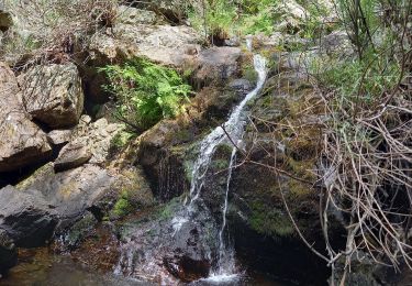
Bu un café à l'auberge de Puechagut (11:15)
Beau panorama à l'auberge de la Cravate (Les Perriers)
Pique-nique dans clairière point coté 861
Bu un café à Aulas à 14:00
Coup de chaleur à Aulas (36°)
Arrivée Hôtel Le Mas de la Prairie au Vigan à 15h30
Trés difficile cause descente dans la chaleur
Plaatsbepaling
Opmerkingen
Wandeltochten in de omgeving
![Tocht Stappen Arphy - Cascade d'Orgon/ monument André Chamson - Photo](https://media.geolcdn.com/t/375/260/e2360f77-e72b-40ce-8fc1-3dfbe5c83de1.jpg&format=jpg&maxdim=2)
![Stappen Stappen](https://static1.geolcdn.com/sitytour/trail-icons/101.png)
Stappen
![](/images/other/stat-length.png)
![](https://static1.geolcdn.com/siteimages/upload/files/16400158638029165_repeat_loop_refresh_sync_direction_icon.png)
![Tocht Stappen Val-d'Aigoual - col de la Lusette - Pic de Barette - col de Montals - L'Espérou - Photo](https://media.geolcdn.com/t/375/260/ext.jpg?maxdim=2&url=https%3A%2F%2Fstatic1.geolcdn.com%2Fsiteimages%2Fupload%2Ffiles%2F1553511878bg_sport_marche.png)
![Stappen Stappen](https://static1.geolcdn.com/sitytour/trail-icons/101.png)
Stappen
![](/images/other/stat-length.png)
![](https://static1.geolcdn.com/siteimages/upload/files/16400158638029165_repeat_loop_refresh_sync_direction_icon.png)
![Tocht Stappen Meyrueis - Bois de la Dauphine - Photo](https://media.geolcdn.com/t/375/260/a7cc8742-6cf3-4cba-a6a2-d1c0486babc2.jpg&format=jpg&maxdim=2)
![Stappen Stappen](https://static1.geolcdn.com/sitytour/trail-icons/101.png)
Stappen
![](/images/other/stat-length.png)
![](https://static1.geolcdn.com/siteimages/upload/files/16400158638029165_repeat_loop_refresh_sync_direction_icon.png)
![Tocht Stappen Val-d'Aigoual - les cascades de l'aigoual par seyrerede - Photo](https://media.geolcdn.com/t/375/260/f9837145-dbac-42c7-abcf-7cbb3f01b62c.jpg&format=jpg&maxdim=2)
![Stappen Stappen](https://static1.geolcdn.com/sitytour/trail-icons/101.png)
Stappen
![](/images/other/stat-length.png)
![](https://static1.geolcdn.com/siteimages/upload/files/16400158638029165_repeat_loop_refresh_sync_direction_icon.png)
![Tocht Stappen Val-d'Aigoual - serreyrede à l aigoual par arboretum - Photo](https://media.geolcdn.com/t/375/260/2be9adc5-67d2-49de-acda-0293aa7a92e9.jpg&format=jpg&maxdim=2)
![Stappen Stappen](https://static1.geolcdn.com/sitytour/trail-icons/101.png)
Stappen
![](/images/other/stat-length.png)
![](https://static1.geolcdn.com/siteimages/upload/files/16400158638029165_repeat_loop_refresh_sync_direction_icon.png)
![Tocht Stappen Val-d'Aigoual - Serreyrede-caumette-Pra peyrot - Photo](https://media.geolcdn.com/t/375/260/4bd7c368-ffdb-4e2f-8b71-be78c10adff8.jpg&format=jpg&maxdim=2)
![Stappen Stappen](https://static1.geolcdn.com/sitytour/trail-icons/101.png)
Stappen
![](/images/other/stat-length.png)
![](https://static1.geolcdn.com/siteimages/upload/files/16400158638029165_repeat_loop_refresh_sync_direction_icon.png)
![Tocht Stappen Bassurels - Mont Aigoual Meyrues - Photo](https://media.geolcdn.com/t/375/260/6ddc0c7f-3198-46c8-9615-a233dbac5c7f.jpg&format=jpg&maxdim=2)
![Stappen Stappen](https://static1.geolcdn.com/sitytour/trail-icons/101.png)
Stappen
![](/images/other/stat-length.png)
![](https://static1.geolcdn.com/siteimages/upload/files/16400158638029165_repeat_loop_refresh_sync_direction_icon.png)
![Tocht Stappen Bassurels - Observatoire Mont Aigoual / Meyrueis - Photo](https://media.geolcdn.com/t/375/260/12e8418a-66c5-46a2-8d87-f4dcc8a1a26c.jpg&format=jpg&maxdim=2)
![Stappen Stappen](https://static1.geolcdn.com/sitytour/trail-icons/101.png)
Stappen
![](/images/other/stat-length.png)
![](https://static1.geolcdn.com/siteimages/upload/files/16400158638029165_repeat_loop_refresh_sync_direction_icon.png)
![Tocht Stappen Val-d'Aigoual - PLO de VALBELLE - Photo](https://media.geolcdn.com/t/375/260/5c0bf513-bea3-4d2c-8dc7-aabb01646242.jpg&format=jpg&maxdim=2)
![Stappen Stappen](https://static1.geolcdn.com/sitytour/trail-icons/101.png)
Stappen
![](/images/other/stat-length.png)
![](https://static1.geolcdn.com/siteimages/upload/files/16400158638029165_repeat_loop_refresh_sync_direction_icon.png)