![](/images/other/stat-length.png)
![Tocht Stappen Chamberet - SityTrail - Correze j1 - Photo](https://media.geolcdn.com/t/1900/400/ext.pjpeg?maxdim=2&url=https%3A%2F%2Fstatic1.geolcdn.com%2Fsiteimages%2Fupload%2Ffiles%2F1553511878bg_sport_marche.png)
SityTrail - Correze j1
CIE NPS
Gebruiker
![Lengte](/images/other/stat-length.png)
Lengte
21 km
![Max. hoogte](https://static1.geolcdn.com/siteimages/upload/files/1508320355ic_sort_altitude_max_24dp.png)
Max. hoogte
731 m
![Positief hoogteverschil](https://static1.geolcdn.com/siteimages/upload/files/1508320355ic_sort_den_pos_24dp.png)
Positief hoogteverschil
680 m
![Km-Effort](/images/other/stat-length.png)
Km-Effort
30 km
![Min. hoogte](https://static1.geolcdn.com/siteimages/upload/files/1508320355ic_sort_altitude_min_24dp.png)
Min. hoogte
393 m
![Negatief hoogteverschil](https://static1.geolcdn.com/siteimages/upload/files/1508320355ic_sort_den_neg_24dp.png)
Negatief hoogteverschil
489 m
![Boucle](https://static1.geolcdn.com/siteimages/upload/files/16400158638029165_repeat_loop_refresh_sync_direction_icon.png)
Boucle
Neen
Datum van aanmaak :
2020-03-14 15:52:55.007
Laatste wijziging :
2020-08-29 11:46:49.009
![Stappen](https://static1.geolcdn.com/sitytour/trail-icons/101.png)
7h04
Moeilijkheid : Zeer moeilijk
![Scan deze QR-code om de tocht te openen in de SityTrail-applicatie](https://capi.geolives.com/qq0zvz2zws4bq2lad0pu/sitytour/trails/2526327/qr.png?size=200)
Gratisgps-wandelapplicatie
Over ons
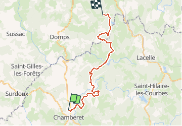
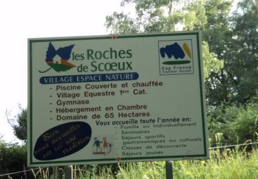
Tocht Stappen van 21 km beschikbaar op Nieuw-Aquitanië, Corrèze, Chamberet. Deze tocht wordt voorgesteld door CIE NPS.
Beschrijving
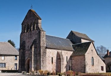
Variante de 35 km sur le chemin vers Rocamadour et Saint-Jacques-de-Compostelle. Retrouvez tous les hébergements et services partenaires sur http://www.chemin-de-st-jacques-voie-de-rocamadour-limousin-haut-quercy.fr
Plaatsbepaling
Land:
France
Regio :
Nieuw-Aquitanië
Departement/Provincie :
Corrèze
Gemeente :
Chamberet
Locatie:
Unknown
Vertrek:(Dec)
Vertrek:(UTM)
400194 ; 5049348 (31T) N.
Opmerkingen
Wandeltochten in de omgeving
![Tocht Stappen Chamberet - Puy Saumon - Chamberet - Photo](https://media.geolcdn.com/t/375/260/ext.jpg?maxdim=2&url=https%3A%2F%2Fservices.sitytrail.com%2FGeolivesWS%2FDownloadMedia.ashx%3FTrailID%3D318094%26Media%3D17552_1.jpg)
![Stappen Stappen](https://static1.geolcdn.com/sitytour/trail-icons/101.png)
Puy Saumon - Chamberet
Stappen
Medium
(1)
Chamberet,
Nieuw-Aquitanië,
Corrèze,
France
![](/images/other/stat-length.png)
11,2 km | 15,7 km-effort
2h 30min
![](https://static1.geolcdn.com/siteimages/upload/files/16400158638029165_repeat_loop_refresh_sync_direction_icon.png)
Ja
![Tocht Stappen Chamberet - Balade Chambertoise - Chamberet - Photo](https://media.geolcdn.com/t/375/260/ext.jpg?maxdim=2&url=https%3A%2F%2Fservices.sitytrail.com%2FGeolivesWS%2FDownloadMedia.ashx%3FTrailID%3D318057%26Media%3D17529_3.jpg)
![Stappen Stappen](https://static1.geolcdn.com/sitytour/trail-icons/101.png)
Balade Chambertoise - Chamberet
Stappen
Medium
(1)
Chamberet,
Nieuw-Aquitanië,
Corrèze,
France
![](/images/other/stat-length.png)
8,1 km | 10,4 km-effort
2h 0min
![](https://static1.geolcdn.com/siteimages/upload/files/16400158638029165_repeat_loop_refresh_sync_direction_icon.png)
Ja
![Tocht Stappen Chamberet - Chamberet - L'arboretum - Photo](https://media.geolcdn.com/t/375/260/3e523c5b-3c2f-439a-9f2c-60c0aeaf0dc3.jpg&format=jpg&maxdim=2)
![Stappen Stappen](https://static1.geolcdn.com/sitytour/trail-icons/101.png)
Chamberet - L'arboretum
Stappen
Heel gemakkelijk
Chamberet,
Nieuw-Aquitanië,
Corrèze,
France
![](/images/other/stat-length.png)
2,1 km | 2,8 km-effort
1h 10min
![](https://static1.geolcdn.com/siteimages/upload/files/16400158638029165_repeat_loop_refresh_sync_direction_icon.png)
Ja
![Tocht Stappen Chamberet - Les Roches de Scoeux - Chamberet - Photo](https://media.geolcdn.com/t/375/260/ext.jpg?maxdim=2&url=https%3A%2F%2Fservices.sitytrail.com%2FGeolivesWS%2FDownloadMedia.ashx%3FTrailID%3D318093%26Media%3D17551_2.jpg)
![Stappen Stappen](https://static1.geolcdn.com/sitytour/trail-icons/101.png)
Les Roches de Scoeux - Chamberet
Stappen
Medium
Chamberet,
Nieuw-Aquitanië,
Corrèze,
France
![](/images/other/stat-length.png)
9,5 km | 12,8 km-effort
2h 30min
![](https://static1.geolcdn.com/siteimages/upload/files/16400158638029165_repeat_loop_refresh_sync_direction_icon.png)
Ja
![Tocht Stappen Meilhards - Le Mavaleix - Meilhards - Photo](https://media.geolcdn.com/t/375/260/ext.jpg?maxdim=2&url=https%3A%2F%2Fservices.sitytrail.com%2FGeolivesWS%2FDownloadMedia.ashx%3FTrailID%3D214820%26Media%3D15329_1.jpg)
![Stappen Stappen](https://static1.geolcdn.com/sitytour/trail-icons/101.png)
Le Mavaleix - Meilhards
Stappen
Medium
Meilhards,
Nieuw-Aquitanië,
Corrèze,
France
![](/images/other/stat-length.png)
9,7 km | 12,3 km-effort
2h 0min
![](https://static1.geolcdn.com/siteimages/upload/files/16400158638029165_repeat_loop_refresh_sync_direction_icon.png)
Neen
![Tocht Stappen Chamberet - Le Mazaufroid - Photo](https://media.geolcdn.com/t/375/260/ext.jpg?maxdim=2&url=https%3A%2F%2Fstatic1.geolcdn.com%2Fsiteimages%2Fupload%2Ffiles%2F1553511878bg_sport_marche.png)
![Stappen Stappen](https://static1.geolcdn.com/sitytour/trail-icons/101.png)
Le Mazaufroid
Stappen
Heel gemakkelijk
Chamberet,
Nieuw-Aquitanië,
Corrèze,
France
![](/images/other/stat-length.png)
3,6 km | 5,2 km-effort
1h 1min
![](https://static1.geolcdn.com/siteimages/upload/files/16400158638029165_repeat_loop_refresh_sync_direction_icon.png)
Ja
![Tocht Stappen Chamberet - SityTrail - Corrèze J3 - Photo](https://media.geolcdn.com/t/375/260/ext.jpg?maxdim=2&url=https%3A%2F%2Fstatic1.geolcdn.com%2Fsiteimages%2Fupload%2Ffiles%2F1553511878bg_sport_marche.png)
![Stappen Stappen](https://static1.geolcdn.com/sitytour/trail-icons/101.png)
SityTrail - Corrèze J3
Stappen
Zeer moeilijk
Chamberet,
Nieuw-Aquitanië,
Corrèze,
France
![](/images/other/stat-length.png)
23 km | 32 km-effort
6h 52min
![](https://static1.geolcdn.com/siteimages/upload/files/16400158638029165_repeat_loop_refresh_sync_direction_icon.png)
Neen
![Tocht Stappen Chamberet - SityTrail - Correze j1 - Photo](https://media.geolcdn.com/t/375/260/ext.jpg?maxdim=2&url=https%3A%2F%2Fstatic1.geolcdn.com%2Fsiteimages%2Fupload%2Ffiles%2F1553511878bg_sport_marche.png)
![Stappen Stappen](https://static1.geolcdn.com/sitytour/trail-icons/101.png)
SityTrail - Correze j1
Stappen
Zeer moeilijk
Chamberet,
Nieuw-Aquitanië,
Corrèze,
France
![](/images/other/stat-length.png)
23 km | 33 km-effort
7h 4min
![](https://static1.geolcdn.com/siteimages/upload/files/16400158638029165_repeat_loop_refresh_sync_direction_icon.png)
Neen
![Tocht Stappen Chamberet - Chamberet - Photo](https://media.geolcdn.com/t/375/260/ext.jpg?maxdim=2&url=https%3A%2F%2Fstatic1.geolcdn.com%2Fsiteimages%2Fupload%2Ffiles%2F1553511878bg_sport_marche.png)
![Stappen Stappen](https://static1.geolcdn.com/sitytour/trail-icons/101.png)
Chamberet
Stappen
Moeilijk
Chamberet,
Nieuw-Aquitanië,
Corrèze,
France
![](/images/other/stat-length.png)
12,8 km | 17,6 km-effort
5h 7min
![](https://static1.geolcdn.com/siteimages/upload/files/16400158638029165_repeat_loop_refresh_sync_direction_icon.png)
Ja