Tocht Stappen Montmédy - La Transgaumaise, étape 3, Montmédy - Orval - Photo

La Transgaumaise, étape 3, Montmédy - Orval

 seghth
seghth

Gebruiker

© OpenStreetMap contributors
Lengte
Lengte
18,4 km
Max. hoogte
Max. hoogte
329 m
Positief hoogteverschil
387 m
Km-Effort
Km-Effort  
24 km
Min. hoogte
Min. hoogte
191 m
Negatief hoogteverschil
386 m
Boucle
Boucle
Neen
Datum van aanmaak :
2020-08-15 09:13:59.815
Laatste wijziging :
2020-08-16 08:38:41.86

(0 Bericht)

Stappen
Stappen
5h00
Moeilijkheid : Heel gemakkelijk

Scan deze QR-code om de tocht te openen in de SityTrail-applicatie

Gratisgps-wandelapplicatie

Logo SityTrail SityTrail

IGN / Geografische instituten

SityTrail uit de App Store downloaden SityTrail uit Google Play downloaden

Logo SityTrail SityTrail World

De wereld gaat voor u open

SityTrail uit de App Store downloaden SityTrail uit Google Play downloaden SityTrail op Huawei AppGallery downloaden

Over ons

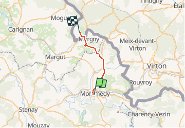
Tocht Stappen van 18,4 km beschikbaar op Grand Est, Meuse, Montmédy. Deze tocht wordt voorgesteld door seghth.

Beschrijving

Jusque Ferme de Bois le Comte à Villers devant Orval

Hoogteprofiel

Plaatsbepaling

Land:
France
Regio :
Grand Est
Departement/Provincie :
Meuse
Gemeente :
Montmédy
Locatie:
Unknown
Vertrek:(UTM)
671197 ; 5487758 (31U) N.

Wandeltochten in de omgeving

Tocht Te voet Montmédy - Boucle de promenade à Montmédy - Photo
Te voet
PRO

Te voet

Gemakkelijk
Montmédy, Grand Est, Meuse, France
5,8 km | 7,8 km-effort
1h 46min
Neen
Tocht Te voet Montmédy - Boucle de promenade autour de la citadelle de Montmédy - Photo
Te voet
PRO

Te voet

Gemakkelijk
(1)
Montmédy, Grand Est, Meuse, France
10,8 km | 13,6 km-effort
3h 5min
Neen
Tocht Te voet Villécloye - La Lorraine Gaumaise - Photo
Te voet
PRO

Te voet

Zeer moeilijk
Villécloye, Grand Est, Meuse, France
37 km | 46 km-effort
10h 26min
Neen
Tocht Stappen Thonnelle - Avioth 3 - Photo
Stappen
vijl

Stappen

Medium
(1)
Thonnelle, Grand Est, Meuse, France
11,7 km | 14,9 km-effort
3h 0min
Ja
Tocht Fiets Montmédy - De Vauban à Charles Quint - Montmédy - Photo
Fiets
tracegps

Fiets

Medium
Montmédy, Grand Est, Meuse, France
47 km | 59 km-effort
2h 45min
Ja
Tocht Stappen Montmédy - Remparts de la Citadelle de Montmédy - Fort Vauban - Photo
Stappen
tracegps

Stappen

Gemakkelijk
Montmédy, Grand Est, Meuse, France
1,1 km | 1,3 km-effort
45min
Ja
Tocht Elektrische fiets Montmédy - SityTrail - De Vauban à Charles Quint - Montmédy - Photo
Elektrische fiets
Efr

Elektrische fiets

Gemakkelijk
Montmédy, Grand Est, Meuse, France
47 km | 59 km-effort
Onbekend
Ja
Tocht Stappen Villécloye - villecloye - Photo
Stappen
jcb48

Stappen

Medium
Villécloye, Grand Est, Meuse, France
7,3 km | 9,4 km-effort
1h 49min
Ja
Tocht Stappen Montmédy - TGaumaise J3 - Photo
Stappen
leon40

Stappen

Medium
Montmédy, Grand Est, Meuse, France
18,9 km | 24 km-effort
5h 6min
Neen


Sluiten
Mijn abonnementen