![](/images/other/stat-length.png)
![Tocht Stappen Bouteville - Bouteville : Sentier des Chaumes Boissieres - Photo](https://media.geolcdn.com/t/1900/400/22055ec8-b5fa-40ee-abea-89a1ac4873e0.jpg&format=pjpeg&maxdim=2)
Bouteville : Sentier des Chaumes Boissieres
alfreson
Gebruiker
![Lengte](/images/other/stat-length.png)
Lengte
7,7 km
![Max. hoogte](https://static1.geolcdn.com/siteimages/upload/files/1508320355ic_sort_altitude_max_24dp.png)
Max. hoogte
108 m
![Positief hoogteverschil](https://static1.geolcdn.com/siteimages/upload/files/1508320355ic_sort_den_pos_24dp.png)
Positief hoogteverschil
103 m
![Km-Effort](/images/other/stat-length.png)
Km-Effort
9,1 km
![Min. hoogte](https://static1.geolcdn.com/siteimages/upload/files/1508320355ic_sort_altitude_min_24dp.png)
Min. hoogte
45 m
![Negatief hoogteverschil](https://static1.geolcdn.com/siteimages/upload/files/1508320355ic_sort_den_neg_24dp.png)
Negatief hoogteverschil
100 m
![Boucle](https://static1.geolcdn.com/siteimages/upload/files/16400158638029165_repeat_loop_refresh_sync_direction_icon.png)
Boucle
Ja
Datum van aanmaak :
2020-08-15 08:23:28.0
Laatste wijziging :
2020-08-15 10:18:31.586
![Stappen](https://static1.geolcdn.com/sitytour/trail-icons/101.png)
1h53
Moeilijkheid : Onbekend
![Paardrijden](https://static1.geolcdn.com/sitytour/trail-icons/301.png)
--
Moeilijkheid : Onbekend
![Scan deze QR-code om de tocht te openen in de SityTrail-applicatie](https://capi.geolives.com/qq0zvz2zws4bq2lad0pu/sitytour/trails/2514668/qr.png?size=200)
Gratisgps-wandelapplicatie
Over ons
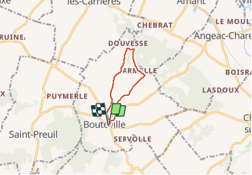
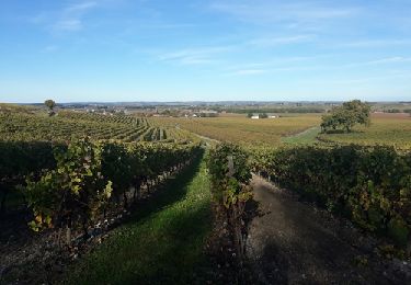
Tocht Stappen van 7,7 km beschikbaar op Nieuw-Aquitanië, Charente, Bouteville. Deze tocht wordt voorgesteld door alfreson.
Beschrijving
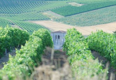
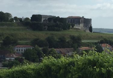
Jolie promenade, facile, au milieu des vignes et des champs de tournesols, avec un petit passage boisé. Au départ, plutôt que prendre la route, prendre l’allée en gazon parallèle à l’accès au château (utilisée ici au retour).
Plaatsbepaling
Land:
France
Regio :
Nieuw-Aquitanië
Departement/Provincie :
Charente
Gemeente :
Bouteville
Locatie:
Unknown
Vertrek:(Dec)
Vertrek:(UTM)
723471 ; 5053550 (30T) N.
Opmerkingen
Wandeltochten in de omgeving
![Tocht Motor Saint-Preuil - The Grande Champagne away from beaten track - Photo](https://media.geolcdn.com/t/375/260/ext.jpg?maxdim=2&url=https%3A%2F%2Fservices.sitytrail.com%2FGeolivesWS%2FDownloadMedia.ashx%3FTrailID%3D208592%26Media%3D2fdcdb5e-bdc8-496d-ba59-fceb5918b661.JPG)
![Motor Motor](https://static1.geolcdn.com/sitytour/trail-icons/400.png)
The Grande Champagne away from beaten track
Motor
Medium
(3)
Saint-Preuil,
Nieuw-Aquitanië,
Charente,
France
![](/images/other/stat-length.png)
53 km | 63 km-effort
2h 40min
![](https://static1.geolcdn.com/siteimages/upload/files/16400158638029165_repeat_loop_refresh_sync_direction_icon.png)
Ja
![Tocht Te voet Bellevigne - Chemin Boisné - Photo](https://media.geolcdn.com/t/375/260/4591f9b2-aa70-4c6e-b273-f78c9a53919a.jpeg&format=jpg&maxdim=2)
![Te voet Te voet](https://static1.geolcdn.com/sitytour/trail-icons/100.png)
Chemin Boisné
Te voet
Gemakkelijk
Bellevigne,
Nieuw-Aquitanië,
Charente,
France
![](/images/other/stat-length.png)
15,6 km | 17 km-effort
3h 51min
![](https://static1.geolcdn.com/siteimages/upload/files/16400158638029165_repeat_loop_refresh_sync_direction_icon.png)
Neen
![Tocht Stappen Bouteville - Bouteville (16120) - Photo](https://media.geolcdn.com/t/375/260/ext.jpg?maxdim=2&url=https%3A%2F%2Fservices.sitytrail.com%2FGeolivesWS%2FDownloadMedia.ashx%3FTrailID%3D815803%26Media%3D20170823110116.jpg)
![Stappen Stappen](https://static1.geolcdn.com/sitytour/trail-icons/101.png)
Bouteville (16120)
Stappen
Gemakkelijk
Bouteville,
Nieuw-Aquitanië,
Charente,
France
![](/images/other/stat-length.png)
14,5 km | 17,6 km-effort
3h 49min
![](https://static1.geolcdn.com/siteimages/upload/files/16400158638029165_repeat_loop_refresh_sync_direction_icon.png)
Ja
![Tocht Stappen Saint-Preuil - Circuit des fontaines et des lavoirs - Variante balisage Violet - Photo](https://media.geolcdn.com/t/375/260/f1f3706f-d2ca-4f73-9e3d-f6e9753eb3cc.jpg&format=jpg&maxdim=2)
![Stappen Stappen](https://static1.geolcdn.com/sitytour/trail-icons/101.png)
Circuit des fontaines et des lavoirs - Variante balisage Violet
Stappen
Medium
Saint-Preuil,
Nieuw-Aquitanië,
Charente,
France
![](/images/other/stat-length.png)
12,8 km | 15,5 km-effort
3h 30min
![](https://static1.geolcdn.com/siteimages/upload/files/16400158638029165_repeat_loop_refresh_sync_direction_icon.png)
Ja
![Tocht Stappen Graves-Saint-Amant - Graves St Amand 14-07-2016 - Photo](https://media.geolcdn.com/t/375/260/ext.jpg?maxdim=2&url=https%3A%2F%2Fservices.sitytrail.com%2FGeolivesWS%2FDownloadMedia.ashx%3FTrailID%3D597986%26Media%3Dfix__20160714113052.jpg)
![Stappen Stappen](https://static1.geolcdn.com/sitytour/trail-icons/101.png)
Graves St Amand 14-07-2016
Stappen
Gemakkelijk
Graves-Saint-Amant,
Nieuw-Aquitanië,
Charente,
France
![](/images/other/stat-length.png)
14,6 km | 16,6 km-effort
3h 17min
![](https://static1.geolcdn.com/siteimages/upload/files/16400158638029165_repeat_loop_refresh_sync_direction_icon.png)
Ja
![Tocht Noords wandelen Lignières-Sonneville - Lignières Sonneville - Photo](https://media.geolcdn.com/t/375/260/ext.jpg?maxdim=2&url=https%3A%2F%2Fstatic1.geolcdn.com%2Fsiteimages%2Fupload%2Ffiles%2F1545311037marcheuse_200dpi.jpg)
![Noords wandelen Noords wandelen](https://static1.geolcdn.com/sitytour/trail-icons/102.png)
Lignières Sonneville
Noords wandelen
Gemakkelijk
Lignières-Sonneville,
Nieuw-Aquitanië,
Charente,
France
![](/images/other/stat-length.png)
14,4 km | 17,7 km-effort
3h 17min
![](https://static1.geolcdn.com/siteimages/upload/files/16400158638029165_repeat_loop_refresh_sync_direction_icon.png)
Ja
![Tocht Stappen Mainxe-Gondeville - mainxe - Photo](https://media.geolcdn.com/t/375/260/ext.jpg?maxdim=2&url=https%3A%2F%2Fstatic1.geolcdn.com%2Fsiteimages%2Fupload%2Ffiles%2F1553511878bg_sport_marche.png)
![Stappen Stappen](https://static1.geolcdn.com/sitytour/trail-icons/101.png)
mainxe
Stappen
Heel gemakkelijk
Mainxe-Gondeville,
Nieuw-Aquitanië,
Charente,
France
![](/images/other/stat-length.png)
12,5 km | 14 km-effort
2h 50min
![](https://static1.geolcdn.com/siteimages/upload/files/16400158638029165_repeat_loop_refresh_sync_direction_icon.png)
Ja
![Tocht Stappen Angeac-Charente - les indiens - Photo](https://media.geolcdn.com/t/375/260/ext.jpg?maxdim=2&url=https%3A%2F%2Fstatic1.geolcdn.com%2Fsiteimages%2Fupload%2Ffiles%2F1553511878bg_sport_marche.png)
![Stappen Stappen](https://static1.geolcdn.com/sitytour/trail-icons/101.png)
les indiens
Stappen
Heel gemakkelijk
Angeac-Charente,
Nieuw-Aquitanië,
Charente,
France
![](/images/other/stat-length.png)
4,9 km | 5,6 km-effort
1h 33min
![](https://static1.geolcdn.com/siteimages/upload/files/16400158638029165_repeat_loop_refresh_sync_direction_icon.png)
Ja
![Tocht Stappen Saint-Preuil - Saint prémilitaire - Photo](https://media.geolcdn.com/t/375/260/ext.jpg?maxdim=2&url=https%3A%2F%2Fstatic1.geolcdn.com%2Fsiteimages%2Fupload%2Ffiles%2F1553511878bg_sport_marche.png)
![Stappen Stappen](https://static1.geolcdn.com/sitytour/trail-icons/101.png)
Saint prémilitaire
Stappen
Saint-Preuil,
Nieuw-Aquitanië,
Charente,
France
![](/images/other/stat-length.png)
9,2 km | 11,1 km-effort
2h 36min
![](https://static1.geolcdn.com/siteimages/upload/files/16400158638029165_repeat_loop_refresh_sync_direction_icon.png)
Ja