![](/images/other/stat-length.png)
![Tocht Fiets Ajaccio - Circuit Ajaccio Sud 2 - Photo](https://media.geolcdn.com/t/1900/400/ext.pjpeg?maxdim=2&url=https%3A%2F%2Fstatic1.geolcdn.com%2Fsiteimages%2Fupload%2Ffiles%2F1524743154velo.jpg)
Circuit Ajaccio Sud 2
Bruno.febvre
Gebruiker
![Lengte](/images/other/stat-length.png)
![Max. hoogte](https://static1.geolcdn.com/siteimages/upload/files/1508320355ic_sort_altitude_max_24dp.png)
![Positief hoogteverschil](https://static1.geolcdn.com/siteimages/upload/files/1508320355ic_sort_den_pos_24dp.png)
![Km-Effort](/images/other/stat-length.png)
![Min. hoogte](https://static1.geolcdn.com/siteimages/upload/files/1508320355ic_sort_altitude_min_24dp.png)
![Negatief hoogteverschil](https://static1.geolcdn.com/siteimages/upload/files/1508320355ic_sort_den_neg_24dp.png)
![Boucle](https://static1.geolcdn.com/siteimages/upload/files/16400158638029165_repeat_loop_refresh_sync_direction_icon.png)
![Fiets](https://static1.geolcdn.com/sitytour/trail-icons/200.png)
4h20
Moeilijkheid : Moeilijk
![Scan deze QR-code om de tocht te openen in de SityTrail-applicatie](https://capi.geolives.com/qq0zvz2zws4bq2lad0pu/sitytour/trails/251448/qr.png?size=200)
Gratisgps-wandelapplicatie
Over ons
Tocht Fiets van 98 km beschikbaar op Corsica, Corse-du-Sud, Ajaccio. Deze tocht wordt voorgesteld door Bruno.febvre.
Beschrijving
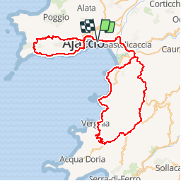
Une première sortie dès les beaux jours de février. Toujours au départ d'Ajaccio. Direction le sud par la N196. Vers Pisciatello on emprunte la D302 sur 2 KM puis D555 vers Porticcio. Ensuite bord de mer jusqu'à Verghia. Prendre direction du col de Cortonu. Une route superbe bordée d’eucalyptus majestueux. La pente est douce et régulière. On passe Bocca di Gradello, Bocca d'Arghellaju et descente vers Pietrosella.Bien rester sur D255. Une courte montée et descente final par Fica pour retourner sur Ajaccio. J'ai rajouté une boucle vers les sanguinaires par le col St Antoine D11B et D111B. Enfin on tourne les jambes en corniche !!! Au total 100 KM ...
Un parcours varié mais il faut en garder un peu pour la courte montée vers le col St Antoine et Bocca di Canareccia.
Bonne sortie vélo à vous tous
Plaatsbepaling
Opmerkingen
Wandeltochten in de omgeving
![Tocht Stappen Ajaccio - Ajacio Hôtel Napoléon - Sanguinaires et chemin des douaniers - Photo](https://media.geolcdn.com/t/375/260/38e4b697-8725-4ea3-8b12-a215168ac55d.jpg&format=jpg&maxdim=2)
![Stappen Stappen](https://static1.geolcdn.com/sitytour/trail-icons/101.png)
Stappen
![](/images/other/stat-length.png)
![](https://static1.geolcdn.com/siteimages/upload/files/16400158638029165_repeat_loop_refresh_sync_direction_icon.png)
![Tocht Stappen Grosseto-Prugna - Porticcio - Bisiano - 14 km - Photo](https://media.geolcdn.com/t/375/260/ext.jpg?maxdim=2&url=https%3A%2F%2Fstatic1.geolcdn.com%2Fsiteimages%2Fupload%2Ffiles%2F1553511878bg_sport_marche.png)
![Stappen Stappen](https://static1.geolcdn.com/sitytour/trail-icons/101.png)
Stappen
![](/images/other/stat-length.png)
![](https://static1.geolcdn.com/siteimages/upload/files/16400158638029165_repeat_loop_refresh_sync_direction_icon.png)
![Tocht Lopen Ajaccio - antennes - Photo](https://media.geolcdn.com/t/375/260/ext.jpg?maxdim=2&url=https%3A%2F%2Fstatic1.geolcdn.com%2Fsiteimages%2Fupload%2Ffiles%2F1524743154running.jpg)
![Lopen Lopen](https://static1.geolcdn.com/sitytour/trail-icons/103.png)
Lopen
![](/images/other/stat-length.png)
![](https://static1.geolcdn.com/siteimages/upload/files/16400158638029165_repeat_loop_refresh_sync_direction_icon.png)
![Tocht Fiets Ajaccio - Boucle lac de Tolla - Photo](https://media.geolcdn.com/t/375/260/ext.jpg?maxdim=2&url=https%3A%2F%2Fstatic1.geolcdn.com%2Fsiteimages%2Fupload%2Ffiles%2F1524743154velo.jpg)
![Fiets Fiets](https://static1.geolcdn.com/sitytour/trail-icons/200.png)
Fiets
![](/images/other/stat-length.png)
![](https://static1.geolcdn.com/siteimages/upload/files/16400158638029165_repeat_loop_refresh_sync_direction_icon.png)
![Tocht Fiets Ajaccio - Boucle Massif du Gozzi - Photo](https://media.geolcdn.com/t/375/260/ext.jpg?maxdim=2&url=https%3A%2F%2Fstatic1.geolcdn.com%2Fsiteimages%2Fupload%2Ffiles%2F1524743154velo.jpg)
![Fiets Fiets](https://static1.geolcdn.com/sitytour/trail-icons/200.png)
Fiets
![](/images/other/stat-length.png)
![](https://static1.geolcdn.com/siteimages/upload/files/16400158638029165_repeat_loop_refresh_sync_direction_icon.png)
![Tocht Stappen Ajaccio - Ajaccio Le sentier des crêtes - Photo](https://media.geolcdn.com/t/375/260/ext.jpg?maxdim=2&url=https%3A%2F%2Fstatic1.geolcdn.com%2Fsiteimages%2Fupload%2Ffiles%2F1553511878bg_sport_marche.png)
![Stappen Stappen](https://static1.geolcdn.com/sitytour/trail-icons/101.png)
Stappen
![](/images/other/stat-length.png)
![](https://static1.geolcdn.com/siteimages/upload/files/16400158638029165_repeat_loop_refresh_sync_direction_icon.png)
![Tocht Stappen Grosseto-Prugna - frassu - Photo](https://media.geolcdn.com/t/375/260/5b18b434-ac9a-4a5d-8336-ad4cffecde08.jpg&format=jpg&maxdim=2)
![Stappen Stappen](https://static1.geolcdn.com/sitytour/trail-icons/101.png)
Stappen
![](/images/other/stat-length.png)
![](https://static1.geolcdn.com/siteimages/upload/files/16400158638029165_repeat_loop_refresh_sync_direction_icon.png)
![Tocht Te voet Ajaccio - Sentier des Crêtes Ajaccio et Grotte Napoléon - Photo](https://media.geolcdn.com/t/375/260/f2d8e298-11bf-45ac-8185-4e19e2dfbeb9.jpg&format=jpg&maxdim=2)
![Te voet Te voet](https://static1.geolcdn.com/sitytour/trail-icons/100.png)
Te voet
![](/images/other/stat-length.png)
![](https://static1.geolcdn.com/siteimages/upload/files/16400158638029165_repeat_loop_refresh_sync_direction_icon.png)
![Tocht Stappen Ajaccio - sentier des crêtes ajaccio - Photo](https://media.geolcdn.com/t/375/260/2ec2494d-0ffd-41c4-bf78-d449e4fa0010.jpg&format=jpg&maxdim=2)
![Stappen Stappen](https://static1.geolcdn.com/sitytour/trail-icons/101.png)
Stappen
![](/images/other/stat-length.png)
![](https://static1.geolcdn.com/siteimages/upload/files/16400158638029165_repeat_loop_refresh_sync_direction_icon.png)