![](/images/other/stat-length.png)
![Tocht Stappen Luik - Luik, musea en shopping - Photo](https://media.geolcdn.com/t/1900/400/ext.pjpeg?maxdim=2&url=https%3A%2F%2Fstatic1.geolcdn.com%2Fsiteimages%2Fupload%2Ffiles%2F1553511878bg_sport_marche.png)
Luik, musea en shopping
zorro
Gebruiker
![Lengte](/images/other/stat-length.png)
![Max. hoogte](https://static1.geolcdn.com/siteimages/upload/files/1508320355ic_sort_altitude_max_24dp.png)
![Positief hoogteverschil](https://static1.geolcdn.com/siteimages/upload/files/1508320355ic_sort_den_pos_24dp.png)
![Km-Effort](/images/other/stat-length.png)
![Min. hoogte](https://static1.geolcdn.com/siteimages/upload/files/1508320355ic_sort_altitude_min_24dp.png)
![Negatief hoogteverschil](https://static1.geolcdn.com/siteimages/upload/files/1508320355ic_sort_den_neg_24dp.png)
![Boucle](https://static1.geolcdn.com/siteimages/upload/files/16400158638029165_repeat_loop_refresh_sync_direction_icon.png)
![Stappen](https://static1.geolcdn.com/sitytour/trail-icons/101.png)
51m
Moeilijkheid : Medium
![Scan deze QR-code om de tocht te openen in de SityTrail-applicatie](https://capi.geolives.com/qq0zvz2zws4bq2lad0pu/sitytour/trails/250838/qr.png?size=200)
Gratisgps-wandelapplicatie
Over ons
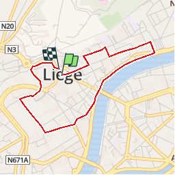
Tocht Stappen van 3,5 km beschikbaar op Wallonië, Luik, Luik. Deze tocht wordt voorgesteld door zorro.
Beschrijving
Luik heeft een ware metamorfose ondergaan de laatste 10 jaar. Place Saint-Lambert, het hart van de stad is daar een mooi voorbeeld van. Auto's parkeren er onder de grond en het plein is één grote wandelzone. Er is ook een nieuw, peperduur en hypermodern treinstation gebouwd. Maar bovenal is Luik een museumstad en er werd wat afgebouwd en vernieuwd de laatste jaren. Het Archéoforum was de start, gevolgd door het Musée de la Vie Wallonne en in 2009 het prestigieuze Grand Curtius.
Plaatsbepaling
Opmerkingen
Wandeltochten in de omgeving
![Tocht Stappen Luik - Nuit du scoutisme - Liège - Photo](https://media.geolcdn.com/t/375/260/9ee5fcc5-2ed6-4f9c-9105-1fa3b4422f73.jpg&format=jpg&maxdim=2)
![Stappen Stappen](https://static1.geolcdn.com/sitytour/trail-icons/101.png)
Stappen
![](/images/other/stat-length.png)
![](https://static1.geolcdn.com/siteimages/upload/files/16400158638029165_repeat_loop_refresh_sync_direction_icon.png)
![Tocht Stappen Luik - coteaux de la citadelle liège - Photo](https://media.geolcdn.com/t/375/260/ext.jpg?maxdim=2&url=https%3A%2F%2Fservices.sitytrail.com%2FGeolivesWS%2FDownloadMedia.ashx%3FTrailID%3D114030%26Media%3D89e4d7f6-fadf-43e4-96ab-3cccd7baadb9.jpg)
![Stappen Stappen](https://static1.geolcdn.com/sitytour/trail-icons/101.png)
Stappen
![](/images/other/stat-length.png)
![](https://static1.geolcdn.com/siteimages/upload/files/16400158638029165_repeat_loop_refresh_sync_direction_icon.png)
![Tocht Stappen Luik - GG-Lg-10_Angleur - Nessonvaux - Photo](https://media.geolcdn.com/t/375/260/04d5e1fb-7fbe-4c80-8636-73a8d0ed7b0e.jpg&format=jpg&maxdim=2)
![Stappen Stappen](https://static1.geolcdn.com/sitytour/trail-icons/101.png)
Stappen
![](/images/other/stat-length.png)
![](https://static1.geolcdn.com/siteimages/upload/files/16400158638029165_repeat_loop_refresh_sync_direction_icon.png)
![Tocht Stappen Luik - liege st lambert versant gauche entre ville et nature - Photo](https://media.geolcdn.com/t/375/260/88c52680-ebe2-4244-8d59-4bcee560958c.jpg&format=jpg&maxdim=2)
![Stappen Stappen](https://static1.geolcdn.com/sitytour/trail-icons/101.png)
Stappen
![](/images/other/stat-length.png)
![](https://static1.geolcdn.com/siteimages/upload/files/16400158638029165_repeat_loop_refresh_sync_direction_icon.png)
![Tocht Stappen Luik - 2021-03-07_15h45m11_1615128300605_UnnMrtGYyrs - Photo](https://media.geolcdn.com/t/375/260/1db82134-c6f1-4cf9-9ec5-4781d8a78844.jpg&format=jpg&maxdim=2)
![Stappen Stappen](https://static1.geolcdn.com/sitytour/trail-icons/101.png)
Stappen
![](/images/other/stat-length.png)
![](https://static1.geolcdn.com/siteimages/upload/files/16400158638029165_repeat_loop_refresh_sync_direction_icon.png)
![Tocht Stappen Luik - angleur . bois st Jacques . sart tilman . bois st laurent . angleur - Photo](https://media.geolcdn.com/t/375/260/5602ae0a-194b-47b6-a04f-43cf9258bbf9.jpg&format=jpg&maxdim=2)
![Stappen Stappen](https://static1.geolcdn.com/sitytour/trail-icons/101.png)
Stappen
![](/images/other/stat-length.png)
![](https://static1.geolcdn.com/siteimages/upload/files/16400158638029165_repeat_loop_refresh_sync_direction_icon.png)
![Tocht Stappen Chaudfontaine - A la découverte des Thermes et Coteaux: La Chapelle St Anne - Photo](https://media.geolcdn.com/t/375/260/6a396cf7-4042-42d2-b979-a2139ec4e634.jpg&format=jpg&maxdim=2)
![Stappen Stappen](https://static1.geolcdn.com/sitytour/trail-icons/101.png)
Stappen
![](/images/other/stat-length.png)
![](https://static1.geolcdn.com/siteimages/upload/files/16400158638029165_repeat_loop_refresh_sync_direction_icon.png)
![Tocht Stappen Luik - Angleur au fil de l'eau - Photo](https://media.geolcdn.com/t/375/260/ext.jpg?maxdim=2&url=https%3A%2F%2Fservices.sitytrail.com%2FGeolivesWS%2FDownloadMedia.ashx%3FTrailID%3D163767%26Media%3D20121122171817.jpeg)
![Stappen Stappen](https://static1.geolcdn.com/sitytour/trail-icons/101.png)
Stappen
![](/images/other/stat-length.png)
![](https://static1.geolcdn.com/siteimages/upload/files/16400158638029165_repeat_loop_refresh_sync_direction_icon.png)
![Tocht Stappen Luik - autour de Streupas - Photo](https://media.geolcdn.com/t/375/260/58869275-889e-413f-9c4b-a5d53686b024.jpg&format=jpg&maxdim=2)
![Stappen Stappen](https://static1.geolcdn.com/sitytour/trail-icons/101.png)