Tocht Te voet Chastre - #200810 - Blanmont Mont-St-Guibert et retour par l'Orne - Photo

#200810 - Blanmont Mont-St-Guibert et retour par l'Orne

 Randos Ouvertes
Randos Ouvertes

Gebruiker

© OpenStreetMap contributors
Lengte
Lengte
5,6 km
Max. hoogte
Max. hoogte
130 m
Positief hoogteverschil
75 m
Km-Effort
Km-Effort  
6,6 km
Min. hoogte
Min. hoogte
86 m
Negatief hoogteverschil
73 m
Boucle
Boucle
Ja
Datum van aanmaak :
2020-08-09 15:27:01.187
Laatste wijziging :
2020-08-09 15:34:58.111

(0 Bericht)

Te voet
Te voet
1h30
Moeilijkheid : Heel gemakkelijk

Scan deze QR-code om de tocht te openen in de SityTrail-applicatie

Gratisgps-wandelapplicatie

Logo SityTrail SityTrail

IGN / Geografische instituten

SityTrail uit de App Store downloaden SityTrail uit Google Play downloaden

Logo SityTrail SityTrail World

De wereld gaat voor u open

SityTrail uit de App Store downloaden SityTrail uit Google Play downloaden SityTrail op Huawei AppGallery downloaden

Over ons

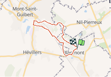
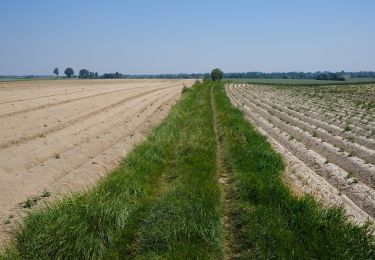
Tocht Te voet van 5,6 km beschikbaar op Wallonië, Waals-Brabant, Chastre. Deze tocht wordt voorgesteld door Randos Ouvertes.

Beschrijving

Projet en cours

Hoogteprofiel

POI's

POI Chastre - Vue nord sur jardin rue de Bau - Photo
Randos Ouvertes
POI Walhain - Ruine de la Tour d'Alvau ou Tour des Sarrasins - Photo
Randos Ouvertes
POI Mont-Saint-Guibert - Vues nord et sud dans le chemin qui descend de la Colline de Penuel - Photo
Randos Ouvertes
MONT-SAINT-GUIBERT 
POI Walhain - Vue sur l'Orne - Photo
Randos Ouvertes
POI Mont-Saint-Guibert - Chapelle à l'entrée de la Rue d'Alvau - Photo
Randos Ouvertes
POI Mont-Saint-Guibert - Vues de l'Orne depuis la Rue d'Alvau - Photo
Randos Ouvertes
MONT-SAINT-GUIBERT 
POI Mont-Saint-Guibert - Vue vers la ligne 161 - Photo
Randos Ouvertes
MONT-SAINT-GUIBERT 
POI Mont-Saint-Guibert - Vue sud-ouest à travers le tunnel sous la ligne 161 - Photo
Randos Ouvertes
POI Chastre - Vue nord Rue Moulin Al Poudre - Photo
Randos Ouvertes
POI Chastre - Vues du Moulin Al Poudre - Photo
Randos Ouvertes

Plaatsbepaling

Land:
Belgium
Regio :
Wallonië
Departement/Provincie :
Waals-Brabant
Gemeente :
Chastre
Locatie:
Chastre-Villeroux-Blanmont
Vertrek:(Dec)
Vertrek:(UTM)
616143 ; 5609205 (31U) N.

Wandeltochten in de omgeving

Tocht Stappen Mont-Saint-Guibert - Balade à Mont-Saint-Guibert - Photo
Stappen
GUIDE
Desrumaux

Stappen

Heel gemakkelijk
(1)
Mont-Saint-Guibert, Wallonië, Waals-Brabant, Belgium
8,4 km | 10,1 km-effort
2h 12min
Ja
Tocht Stappen Chastre - #240223a - Blanmont, Orne, Alvaux, Nil Pierreux*** - Photo
Stappen
Randos Ouvertes

Stappen

Medium
(1)
Chastre, Wallonië, Waals-Brabant, Belgium
6,6 km | 7,8 km-effort
1h 47min
Ja
Tocht Stappen Chaumont-Gistoux - #231016 - Corroy-Le-Grand et le Val d'Ocquière*** (inversé court) - Photo
Stappen
Randos Ouvertes

Stappen

Medium
(2)
Chaumont-Gistoux, Wallonië, Waals-Brabant, Belgium
6,2 km | 7,2 km-effort
1h 38min
Ja
Tocht Stappen Chastre - #230728 - Gentinnes Kongolo - Photo
Stappen
Randos Ouvertes

Stappen

Gemakkelijk
(1)
Chastre, Wallonië, Waals-Brabant, Belgium
5 km | 5,6 km-effort
1h 16min
Ja
Tocht Te voet Walhain - #170829 - Nil Pierreux, carrières de quartzite, Moulin d'Al Poudre et Tour des Sarrasins*** - Photo
Te voet
Randos Ouvertes

Te voet

Heel gemakkelijk
(2)
Walhain, Wallonië, Waals-Brabant, Belgium
8,1 km | 9,9 km-effort
2h 0min
Ja
Tocht Stappen Chastre - Promenade de Villeroux - Photo
Stappen
Chastre1450

Stappen

Medium
(1)
Chastre, Wallonië, Waals-Brabant, Belgium
7,6 km | 8,5 km-effort
1h 53min
Ja
Tocht Stappen Chastre - Balade de la fontaine Saint Géry à Chastre - Photo
Stappen
GaetanHouart

Stappen

Medium
(1)
Chastre, Wallonië, Waals-Brabant, Belgium
7,6 km | 8,6 km-effort
1h 53min
Ja
Tocht Stappen Mont-Saint-Guibert - L'Orne_Chateau de Bierbais - Photo
Stappen
calofrancis

Stappen

Gemakkelijk
(2)
Mont-Saint-Guibert, Wallonië, Waals-Brabant, Belgium
9,4 km | 11,5 km-effort
2h 28min
Ja
Tocht Noords wandelen Mont-Saint-Guibert - Mont St Guibert - Photo
Noords wandelen
MajoisF

Noords wandelen

Heel gemakkelijk
(1)
Mont-Saint-Guibert, Wallonië, Waals-Brabant, Belgium
7,7 km | 9,7 km-effort
2h 2min
Ja


Sluiten
Mijn abonnementen