![](/images/other/stat-length.png)
Matourne st Pierre tour de guet
richardB83
Gebruiker
![Lengte](/images/other/stat-length.png)
Lengte
24 km
![Max. hoogte](https://static1.geolcdn.com/siteimages/upload/files/1508320355ic_sort_altitude_max_24dp.png)
Max. hoogte
859 m
![Positief hoogteverschil](https://static1.geolcdn.com/siteimages/upload/files/1508320355ic_sort_den_pos_24dp.png)
Positief hoogteverschil
637 m
![Km-Effort](/images/other/stat-length.png)
Km-Effort
32 km
![Min. hoogte](https://static1.geolcdn.com/siteimages/upload/files/1508320355ic_sort_altitude_min_24dp.png)
Min. hoogte
411 m
![Negatief hoogteverschil](https://static1.geolcdn.com/siteimages/upload/files/1508320355ic_sort_den_neg_24dp.png)
Negatief hoogteverschil
637 m
![Boucle](https://static1.geolcdn.com/siteimages/upload/files/16400158638029165_repeat_loop_refresh_sync_direction_icon.png)
Boucle
Ja
Datum van aanmaak :
2020-08-09 06:01:27.38
Laatste wijziging :
2020-08-09 16:16:48.085
![Mountainbike](https://static1.geolcdn.com/sitytour/trail-icons/202.png)
3h32
Moeilijkheid : Medium
![Scan deze QR-code om de tocht te openen in de SityTrail-applicatie](https://capi.geolives.com/qq0zvz2zws4bq2lad0pu/sitytour/trails/2507699/qr.png?size=200)
Gratisgps-wandelapplicatie
Over ons
Tocht Mountainbike van 24 km beschikbaar op Provence-Alpes-Côte d'Azur, Var, Flayosc. Deze tocht wordt voorgesteld door richardB83.
Beschrijving
Belle boucle aérienne avec descentes pierreuses et terreuses ombragées. Niveau moyen, pas de passage engagés.
Plaatsbepaling
Land:
France
Regio :
Provence-Alpes-Côte d'Azur
Departement/Provincie :
Var
Gemeente :
Flayosc
Locatie:
Unknown
Vertrek:(Dec)
Vertrek:(UTM)
288608 ; 4826515 (32T) N.
Opmerkingen
Wandeltochten in de omgeving
![Tocht Stappen Ampus - Ampus-Spéluque - Photo](https://media.geolcdn.com/t/375/260/ext.jpg?maxdim=2&url=https%3A%2F%2Fservices.sitytrail.com%2FGeolivesWS%2FDownloadMedia.ashx%3FTrailID%3D524083%26Media%3D1bf67c76-80de-46cf-8ba1-3400b0f4e108.jpg)
![Stappen Stappen](https://static1.geolcdn.com/sitytour/trail-icons/101.png)
Ampus-Spéluque
Stappen
Gemakkelijk
(2)
Ampus,
Provence-Alpes-Côte d'Azur,
Var,
France
![](/images/other/stat-length.png)
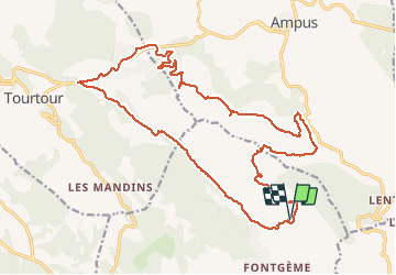
10,1 km | 13,3 km-effort
2h 54min
![](https://static1.geolcdn.com/siteimages/upload/files/16400158638029165_repeat_loop_refresh_sync_direction_icon.png)
Ja
![Tocht Stappen Flayosc - Flayosc - Photo](https://media.geolcdn.com/t/375/260/ext.jpg?maxdim=2&url=https%3A%2F%2Fstatic1.geolcdn.com%2Fsiteimages%2Fupload%2Ffiles%2F1553511878bg_sport_marche.png)
![Stappen Stappen](https://static1.geolcdn.com/sitytour/trail-icons/101.png)
Flayosc
Stappen
Gemakkelijk
(4)
Flayosc,
Provence-Alpes-Côte d'Azur,
Var,
France
![](/images/other/stat-length.png)
8,3 km | 10,6 km-effort
2h 18min
![](https://static1.geolcdn.com/siteimages/upload/files/16400158638029165_repeat_loop_refresh_sync_direction_icon.png)
Ja
![Tocht Stappen Draguignan - Rebouillon le long de la Nartuby - Photo](https://media.geolcdn.com/t/375/260/5546167f-335f-4958-9f3e-7305fd054196.jpg&format=jpg&maxdim=2)
![Stappen Stappen](https://static1.geolcdn.com/sitytour/trail-icons/101.png)
Rebouillon le long de la Nartuby
Stappen
Gemakkelijk
Draguignan,
Provence-Alpes-Côte d'Azur,
Var,
France
![](/images/other/stat-length.png)
4,8 km | 5,9 km-effort
1h 33min
![](https://static1.geolcdn.com/siteimages/upload/files/16400158638029165_repeat_loop_refresh_sync_direction_icon.png)
Ja
![Stappen Stappen](https://static1.geolcdn.com/sitytour/trail-icons/101.png)
Rebouillon - Chapelle St Jean - Châteaudouble
Stappen
Gemakkelijk
Châteaudouble,
Provence-Alpes-Côte d'Azur,
Var,
France
![](/images/other/stat-length.png)
20 km | 28 km-effort
4h 56min
![](https://static1.geolcdn.com/siteimages/upload/files/16400158638029165_repeat_loop_refresh_sync_direction_icon.png)
Ja
![Tocht Stappen Ampus - AMPUS - CIRCUIT - Photo](https://media.geolcdn.com/t/375/260/31ca4f11-f3a7-4149-b8a9-6f608bf34735.jpg&format=jpg&maxdim=2)
![Stappen Stappen](https://static1.geolcdn.com/sitytour/trail-icons/101.png)
AMPUS - CIRCUIT
Stappen
Gemakkelijk
Ampus,
Provence-Alpes-Côte d'Azur,
Var,
France
![](/images/other/stat-length.png)
15,3 km | 19 km-effort
6h 53min
![](https://static1.geolcdn.com/siteimages/upload/files/16400158638029165_repeat_loop_refresh_sync_direction_icon.png)
Ja
![Tocht Wegfiets Draguignan - la clape - Photo](https://media.geolcdn.com/t/375/260/0765a432-74ac-42bd-825e-91e99e328dea.jpg&format=jpg&maxdim=2)
![Wegfiets Wegfiets](https://static1.geolcdn.com/sitytour/trail-icons/201.png)
la clape
Wegfiets
Heel gemakkelijk
Draguignan,
Provence-Alpes-Côte d'Azur,
Var,
France
![](/images/other/stat-length.png)
16,7 km | 18,6 km-effort
1h 56min
![](https://static1.geolcdn.com/siteimages/upload/files/16400158638029165_repeat_loop_refresh_sync_direction_icon.png)
Ja
![Tocht Stappen Lorgues - 20190130 Mentone Est rando réelle. - Photo](https://media.geolcdn.com/t/375/260/ext.jpg?maxdim=2&url=https%3A%2F%2Fservices.sitytrail.com%2FGeolivesWS%2FDownloadMedia.ashx%3FTrailID%3D1104083%26Media%3Dfix__20190130105141.jpg)
![Stappen Stappen](https://static1.geolcdn.com/sitytour/trail-icons/101.png)
20190130 Mentone Est rando réelle.
Stappen
Gemakkelijk
Lorgues,
Provence-Alpes-Côte d'Azur,
Var,
France
![](/images/other/stat-length.png)
17,4 km | 22 km-effort
4h 40min
![](https://static1.geolcdn.com/siteimages/upload/files/16400158638029165_repeat_loop_refresh_sync_direction_icon.png)
Ja
![Tocht Stappen Châteaudouble - Ampus-l'homme mort 4 - Photo](https://media.geolcdn.com/t/375/260/ext.jpg?maxdim=2&url=https%3A%2F%2Fservices.sitytrail.com%2FGeolivesWS%2FDownloadMedia.ashx%3FTrailID%3D530303%26Media%3Dfix__20150304123240.jpg)
![Stappen Stappen](https://static1.geolcdn.com/sitytour/trail-icons/101.png)
Ampus-l'homme mort 4
Stappen
Gemakkelijk
Châteaudouble,
Provence-Alpes-Côte d'Azur,
Var,
France
![](/images/other/stat-length.png)
14,5 km | 17,5 km-effort
3h 50min
![](https://static1.geolcdn.com/siteimages/upload/files/16400158638029165_repeat_loop_refresh_sync_direction_icon.png)
Ja
![Tocht Stappen Châteaudouble - Châteaudouble-L'homme mort - Photo](https://media.geolcdn.com/t/375/260/ext.jpg?maxdim=2&url=https%3A%2F%2Fservices.sitytrail.com%2FGeolivesWS%2FDownloadMedia.ashx%3FTrailID%3D392246%26Media%3Dfix__20150304094655.jpg)
![Stappen Stappen](https://static1.geolcdn.com/sitytour/trail-icons/101.png)
Châteaudouble-L'homme mort
Stappen
Gemakkelijk
Châteaudouble,
Provence-Alpes-Côte d'Azur,
Var,
France
![](/images/other/stat-length.png)
14,5 km | 17,5 km-effort
3h 52min
![](https://static1.geolcdn.com/siteimages/upload/files/16400158638029165_repeat_loop_refresh_sync_direction_icon.png)
Ja