![](/images/other/stat-length.png)
![Tocht Stappen Riedisheim - randogps68-193 - Photo](https://media.geolcdn.com/t/1900/400/ext.pjpeg?maxdim=2&url=https%3A%2F%2Fstatic1.geolcdn.com%2Fsiteimages%2Fupload%2Ffiles%2F1553511878bg_sport_marche.png)
randogps68-193
E.BURCK
Gebruiker
![Lengte](/images/other/stat-length.png)
![Max. hoogte](https://static1.geolcdn.com/siteimages/upload/files/1508320355ic_sort_altitude_max_24dp.png)
![Positief hoogteverschil](https://static1.geolcdn.com/siteimages/upload/files/1508320355ic_sort_den_pos_24dp.png)
![Km-Effort](/images/other/stat-length.png)
![Min. hoogte](https://static1.geolcdn.com/siteimages/upload/files/1508320355ic_sort_altitude_min_24dp.png)
![Negatief hoogteverschil](https://static1.geolcdn.com/siteimages/upload/files/1508320355ic_sort_den_neg_24dp.png)
![Boucle](https://static1.geolcdn.com/siteimages/upload/files/16400158638029165_repeat_loop_refresh_sync_direction_icon.png)
![Stappen](https://static1.geolcdn.com/sitytour/trail-icons/101.png)
2h27
Moeilijkheid : Gemakkelijk
![Scan deze QR-code om de tocht te openen in de SityTrail-applicatie](https://capi.geolives.com/qq0zvz2zws4bq2lad0pu/sitytour/trails/2507097/qr.png?size=200)
Gratisgps-wandelapplicatie
Over ons
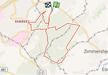
Tocht Stappen van 10 km beschikbaar op Grand Est, Haut-Rhin, Riedisheim. Deze tocht wordt voorgesteld door E.BURCK.
Beschrijving
Départ randonnée :
Parking centre sportif du Waldeck, 68400 Riedisheim (Haut-Rhin)
Un agréable et facile circuit en boucle de 9 km à travers le Tannenwald,
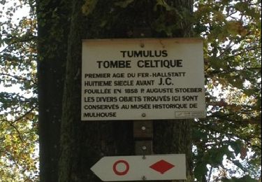
passant successivement au Tumulus, à la Vue des Alpes, au carrefour du Rotlaub,
à proximité de la tour relais Télécom et du zoo de Mulhouse.
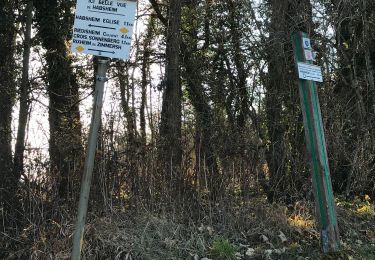
Du parking, suivre la route et le balisage triangle rouge vers le sud sur 500 m,
virer à gauche et prendre le sentier balisé cercle rouge.
Suivre l’excellent balisage cercle rouge sur tout le circuit.
A la fin du circuit du cercle rouge, prendre à gauche pour revenir au parking du centre sportif du Waldeck.
Le circuit peut également se faire à partir de l’entrée du zoo de Mulhouse.
Carte IGN 3720 ET Mulhouse
extrait de https://www.randogps.net/
Plaatsbepaling
Opmerkingen
Wandeltochten in de omgeving
![Tocht Stappen Mulhouse - 20230904 - Mulhouse - Visite - Photo](https://media.geolcdn.com/t/375/260/ext.jpg?maxdim=2&url=https%3A%2F%2Fstatic1.geolcdn.com%2Fsiteimages%2Fupload%2Ffiles%2F1553511878bg_sport_marche.png)
![Stappen Stappen](https://static1.geolcdn.com/sitytour/trail-icons/101.png)
Stappen
![](/images/other/stat-length.png)
![](https://static1.geolcdn.com/siteimages/upload/files/16400158638029165_repeat_loop_refresh_sync_direction_icon.png)
![Tocht Te voet Mulhouse - Anneau rouge - Photo](https://media.geolcdn.com/t/375/260/37b7f0fa-a2dc-4c5c-8083-bd326125a75f.jpeg&format=jpg&maxdim=2)
![Te voet Te voet](https://static1.geolcdn.com/sitytour/trail-icons/100.png)
Te voet
![](/images/other/stat-length.png)
![](https://static1.geolcdn.com/siteimages/upload/files/16400158638029165_repeat_loop_refresh_sync_direction_icon.png)
![Tocht Stappen Riedisheim - Mulhouse / Ferrette..02/05/2024..les Marcheurs - Photo](https://media.geolcdn.com/t/375/260/0569a039-8a76-4348-87de-495bb0a0a672.jpg&format=jpg&maxdim=2)
![Stappen Stappen](https://static1.geolcdn.com/sitytour/trail-icons/101.png)
Stappen
![](/images/other/stat-length.png)
![](https://static1.geolcdn.com/siteimages/upload/files/16400158638029165_repeat_loop_refresh_sync_direction_icon.png)
![Tocht Stappen Riedisheim - circuit circulaire du Rothlaub - Photo](https://media.geolcdn.com/t/375/260/52ee7239-97bc-4674-8889-fbce10a40926.jpg&format=jpg&maxdim=2)
![Stappen Stappen](https://static1.geolcdn.com/sitytour/trail-icons/101.png)
Stappen
![](/images/other/stat-length.png)
![](https://static1.geolcdn.com/siteimages/upload/files/16400158638029165_repeat_loop_refresh_sync_direction_icon.png)
![Andere activiteiten Andere activiteiten](https://static1.geolcdn.com/sitytour/trail-icons/900.png)
Andere activiteiten
![](/images/other/stat-length.png)
![](https://static1.geolcdn.com/siteimages/upload/files/16400158638029165_repeat_loop_refresh_sync_direction_icon.png)
![Tocht Andere activiteiten Mulhouse - Grand Est - Ligne 4 - Paris Mulhouse (section de :Montreux-Vieux à Mulhouse) - Photo](https://media.geolcdn.com/t/375/260/ext.jpg?maxdim=2&url=https%3A%2F%2Fservices.sitytrail.com%2FGeolivesWS%2FDownloadMedia.ashx%3FTrailID%3D698035%26Media%3D11056c93-5cb0-40f3-b680-c38bf618444f.jpg)
![Andere activiteiten Andere activiteiten](https://static1.geolcdn.com/sitytour/trail-icons/900.png)
Andere activiteiten
![](/images/other/stat-length.png)
![](https://static1.geolcdn.com/siteimages/upload/files/16400158638029165_repeat_loop_refresh_sync_direction_icon.png)
![Tocht Stappen Rixheim - JD 17/20 Collines de Habsheim - Photo](https://media.geolcdn.com/t/375/260/1b74da9b-0a8b-4591-bac7-30aefa1bf73f.jpg&format=jpg&maxdim=2)
![Stappen Stappen](https://static1.geolcdn.com/sitytour/trail-icons/101.png)
Stappen
![](/images/other/stat-length.png)
![](https://static1.geolcdn.com/siteimages/upload/files/16400158638029165_repeat_loop_refresh_sync_direction_icon.png)
![Tocht Fiets Mulhouse - waldeck - Photo](https://media.geolcdn.com/t/375/260/ext.jpg?maxdim=2&url=https%3A%2F%2Fservices.sitytrail.com%2FGeolivesWS%2FDownloadMedia.ashx%3FTrailID%3D160743%26Media%3D20121101114820.jpg)
![Fiets Fiets](https://static1.geolcdn.com/sitytour/trail-icons/200.png)
Fiets
![](/images/other/stat-length.png)
![](https://static1.geolcdn.com/siteimages/upload/files/16400158638029165_repeat_loop_refresh_sync_direction_icon.png)
![Tocht Stappen Riedisheim - 2024 09 19 - Photo](https://media.geolcdn.com/t/375/260/e0e32f03-c290-4273-8e04-3e287a963c37.jpg&format=jpg&maxdim=2)
![Stappen Stappen](https://static1.geolcdn.com/sitytour/trail-icons/101.png)
Stappen
![](/images/other/stat-length.png)
![](https://static1.geolcdn.com/siteimages/upload/files/16400158638029165_repeat_loop_refresh_sync_direction_icon.png)