![](/images/other/stat-length.png)
![Tocht Mountainbike Airolo - WallisBike 11 Airolo - Andermatt - Photo](https://media.geolcdn.com/t/1900/400/ext.pjpeg?maxdim=2&url=https%3A%2F%2Fstatic1.geolcdn.com%2Fsiteimages%2Fupload%2Ffiles%2F1524743154velo.jpg)
WallisBike 11 Airolo - Andermatt
ovronne
Gebruiker
![Lengte](/images/other/stat-length.png)
Lengte
32 km
![Max. hoogte](https://static1.geolcdn.com/siteimages/upload/files/1508320355ic_sort_altitude_max_24dp.png)
Max. hoogte
2253 m
![Positief hoogteverschil](https://static1.geolcdn.com/siteimages/upload/files/1508320355ic_sort_den_pos_24dp.png)
Positief hoogteverschil
1366 m
![Km-Effort](/images/other/stat-length.png)
Km-Effort
49 km
![Min. hoogte](https://static1.geolcdn.com/siteimages/upload/files/1508320355ic_sort_altitude_min_24dp.png)
Min. hoogte
1146 m
![Negatief hoogteverschil](https://static1.geolcdn.com/siteimages/upload/files/1508320355ic_sort_den_neg_24dp.png)
Negatief hoogteverschil
1073 m
![Boucle](https://static1.geolcdn.com/siteimages/upload/files/16400158638029165_repeat_loop_refresh_sync_direction_icon.png)
Boucle
Neen
Datum van aanmaak :
2014-12-11 00:00:00.0
Laatste wijziging :
2014-12-11 00:00:00.0
![Mountainbike](https://static1.geolcdn.com/sitytour/trail-icons/202.png)
4h15
Moeilijkheid : Onbekend
![Scan deze QR-code om de tocht te openen in de SityTrail-applicatie](https://capi.geolives.com/qq0zvz2zws4bq2lad0pu/sitytour/trails/25064/qr.png?size=200)
Gratisgps-wandelapplicatie
Over ons
Tocht Mountainbike van 32 km beschikbaar op Ticino, Distretto di Leventina, Airolo. Deze tocht wordt voorgesteld door ovronne.
Beschrijving
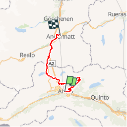
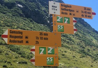
Onzième étape de la traversée des Alpes Suisse de St-Gingolph à Scuol.
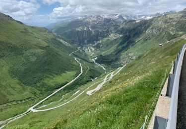
Départ d''Airolo, montée jusqu''au Passo Scimfuss. Direction GotthardPass, puis descente sur Hospental pour finir à Andermatt.
Plaatsbepaling
Land:
Switzerland
Regio :
Ticino
Departement/Provincie :
Distretto di Leventina
Gemeente :
Airolo
Locatie:
Unknown
Vertrek:(Dec)
Vertrek:(UTM)
469879 ; 5152757 (32T) N.
Opmerkingen
Wandeltochten in de omgeving
![Tocht Te voet Airolo - Strada Bassa - Photo](https://media.geolcdn.com/t/375/260/f81afdc9-f182-46ad-8198-37dc98335834.jpeg&format=jpg&maxdim=2)
![Te voet Te voet](https://static1.geolcdn.com/sitytour/trail-icons/100.png)
Strada Bassa
Te voet
Medium
Airolo,
Ticino,
Distretto di Leventina,
Switzerland
![](/images/other/stat-length.png)
19,2 km | 27 km-effort
6h 3min
![](https://static1.geolcdn.com/siteimages/upload/files/16400158638029165_repeat_loop_refresh_sync_direction_icon.png)
Neen
![Tocht Te voet Airolo - Strada degli Alpi - Photo](https://media.geolcdn.com/t/375/260/28d1a178-b79f-4e14-a216-ad8ff4ed8b5f.jpeg&format=jpg&maxdim=2)
![Te voet Te voet](https://static1.geolcdn.com/sitytour/trail-icons/100.png)
Strada degli Alpi
Te voet
Gemakkelijk
Airolo,
Ticino,
Distretto di Leventina,
Switzerland
![](/images/other/stat-length.png)
13,2 km | 19,8 km-effort
4h 30min
![](https://static1.geolcdn.com/siteimages/upload/files/16400158638029165_repeat_loop_refresh_sync_direction_icon.png)
Neen
![Tocht Te voet Airolo - Val Canaria-Airolo - Photo](https://media.geolcdn.com/t/375/260/3c8cce33-76eb-4790-8142-9295e7104542.jpeg&format=jpg&maxdim=2)
![Te voet Te voet](https://static1.geolcdn.com/sitytour/trail-icons/100.png)
Val Canaria-Airolo
Te voet
Gemakkelijk
Airolo,
Ticino,
Distretto di Leventina,
Switzerland
![](/images/other/stat-length.png)
5,3 km | 7,8 km-effort
1h 46min
![](https://static1.geolcdn.com/siteimages/upload/files/16400158638029165_repeat_loop_refresh_sync_direction_icon.png)
Neen
![Tocht Te voet Airolo - Strada Alta - Photo](https://media.geolcdn.com/t/375/260/a11c2b9a-53fe-4f2a-84f2-135767ac283d.jpeg&format=jpg&maxdim=2)
![Te voet Te voet](https://static1.geolcdn.com/sitytour/trail-icons/100.png)
Strada Alta
Te voet
Zeer moeilijk
Airolo,
Ticino,
Distretto di Leventina,
Switzerland
![](/images/other/stat-length.png)
44 km | 67 km-effort
15h 17min
![](https://static1.geolcdn.com/siteimages/upload/files/16400158638029165_repeat_loop_refresh_sync_direction_icon.png)
Neen
![Tocht Te voet Airolo - Ospizio San Gottardo-Hospental - Photo](https://media.geolcdn.com/t/375/260/7913350d-e445-44c6-bc03-c3845fc867df.jpeg&format=jpg&maxdim=2)
![Te voet Te voet](https://static1.geolcdn.com/sitytour/trail-icons/100.png)
Ospizio San Gottardo-Hospental
Te voet
Gemakkelijk
Airolo,
Ticino,
Distretto di Leventina,
Switzerland
![](/images/other/stat-length.png)
9,1 km | 11,6 km-effort
2h 38min
![](https://static1.geolcdn.com/siteimages/upload/files/16400158638029165_repeat_loop_refresh_sync_direction_icon.png)
Neen
![Tocht Te voet Airolo - Lago della Sella - fixme - Photo](https://media.geolcdn.com/t/375/260/bac52592-0270-43aa-838e-a06b26324961.jpeg&format=jpg&maxdim=2)
![Te voet Te voet](https://static1.geolcdn.com/sitytour/trail-icons/100.png)
Lago della Sella - fixme
Te voet
Gemakkelijk
Airolo,
Ticino,
Distretto di Leventina,
Switzerland
![](/images/other/stat-length.png)
3 km | 5,4 km-effort
1h 13min
![](https://static1.geolcdn.com/siteimages/upload/files/16400158638029165_repeat_loop_refresh_sync_direction_icon.png)
Neen
![Tocht Wegfiets Airolo - Airolo 3 cols - Photo](https://media.geolcdn.com/t/375/260/c7e30b72-19e3-4b6a-9b61-119f8d0a22db.jpeg&format=jpg&maxdim=2)
![Wegfiets Wegfiets](https://static1.geolcdn.com/sitytour/trail-icons/201.png)
Airolo 3 cols
Wegfiets
Zeer moeilijk
Airolo,
Ticino,
Distretto di Leventina,
Switzerland
![](/images/other/stat-length.png)
100 km | 144 km-effort
8h 43min
![](https://static1.geolcdn.com/siteimages/upload/files/16400158638029165_repeat_loop_refresh_sync_direction_icon.png)
Ja
![Tocht Wegfiets Airolo - Airolo barrage Ambri - Photo](https://media.geolcdn.com/t/375/260/9a5712b3-59c7-4bf7-903a-892ab1fd81eb.heic&format=jpg&maxdim=2)
![Wegfiets Wegfiets](https://static1.geolcdn.com/sitytour/trail-icons/201.png)
Airolo barrage Ambri
Wegfiets
Zeer moeilijk
Airolo,
Ticino,
Distretto di Leventina,
Switzerland
![](/images/other/stat-length.png)
28 km | 43 km-effort
2h 35min
![](https://static1.geolcdn.com/siteimages/upload/files/16400158638029165_repeat_loop_refresh_sync_direction_icon.png)
Ja
![Tocht Te voet Airolo - Sopra Valle-Buco di Ce - Photo](https://media.geolcdn.com/t/375/260/ext.jpg?maxdim=2&url=https%3A%2F%2Fstatic1.geolcdn.com%2Fsiteimages%2Fupload%2Ffiles%2F1545311037marcheuse_200dpi.jpg)
![Te voet Te voet](https://static1.geolcdn.com/sitytour/trail-icons/100.png)
Sopra Valle-Buco di Ce
Te voet
Gemakkelijk
Airolo,
Ticino,
Distretto di Leventina,
Switzerland
![](/images/other/stat-length.png)
3,2 km | 6,2 km-effort
1h 24min
![](https://static1.geolcdn.com/siteimages/upload/files/16400158638029165_repeat_loop_refresh_sync_direction_icon.png)
Neen