![](/images/other/stat-length.png)
![Tocht Te voet Rontignon - UZOS la boucle de la glandée pour M2 - Photo](https://media.geolcdn.com/t/1900/400/ext.pjpeg?maxdim=2&url=https%3A%2F%2Fstatic1.geolcdn.com%2Fsiteimages%2Fupload%2Ffiles%2F1545311037marcheuse_200dpi.jpg)
UZOS la boucle de la glandée pour M2
marmotte65
Gebruiker GUIDE
![Lengte](/images/other/stat-length.png)
![Max. hoogte](https://static1.geolcdn.com/siteimages/upload/files/1508320355ic_sort_altitude_max_24dp.png)
![Positief hoogteverschil](https://static1.geolcdn.com/siteimages/upload/files/1508320355ic_sort_den_pos_24dp.png)
![Km-Effort](/images/other/stat-length.png)
![Min. hoogte](https://static1.geolcdn.com/siteimages/upload/files/1508320355ic_sort_altitude_min_24dp.png)
![Negatief hoogteverschil](https://static1.geolcdn.com/siteimages/upload/files/1508320355ic_sort_den_neg_24dp.png)
![Boucle](https://static1.geolcdn.com/siteimages/upload/files/16400158638029165_repeat_loop_refresh_sync_direction_icon.png)
![Te voet](https://static1.geolcdn.com/sitytour/trail-icons/100.png)
--
Moeilijkheid : Gemakkelijk
![Scan deze QR-code om de tocht te openen in de SityTrail-applicatie](https://capi.geolives.com/qq0zvz2zws4bq2lad0pu/sitytour/trails/2505967/qr.png?size=200)
Gratisgps-wandelapplicatie
Over ons
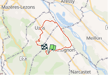
Tocht Te voet van 5,9 km beschikbaar op Nieuw-Aquitanië, Pyrénées-Atlantiques, Rontignon. Deze tocht wordt voorgesteld door marmotte65.
Beschrijving
Pour joindre le départ en venant de UZOS aller jusqu’a Rontignon au feu de la mairie tourner à droite et au prochain carrefour en Y (a la croix) prendre a droite jusqu’a un Y (containers d'ordures)indiquant à D le chemin des écureuils et l a variante de la boucle de la glandée se garer là . . trace sur la base de la boucle de la glandée avec un départ commun au niveau de la variante. controle effectué le 17/08/2020
Coordonnées GPS N 43 15 31.1
W ooo 20 21.2
Plaatsbepaling
Opmerkingen
Wandeltochten in de omgeving
![Tocht Stappen Rontignon - Coteaux de Rontignon - Photo](https://media.geolcdn.com/t/375/260/ext.jpg?maxdim=2&url=https%3A%2F%2Fservices.sitytrail.com%2FGeolivesWS%2FDownloadMedia.ashx%3FTrailID%3D103073%26Media%3D4763_4.jpg)
![Stappen Stappen](https://static1.geolcdn.com/sitytour/trail-icons/101.png)
Stappen
![](/images/other/stat-length.png)
![](https://static1.geolcdn.com/siteimages/upload/files/16400158638029165_repeat_loop_refresh_sync_direction_icon.png)
![Tocht Stappen Pau - PAU RS entre jardins et villa quartier Trespoey](https://media.geolcdn.com/t/375/260/4ef921b3-2e64-48c5-a483-91dfaca18d96.jpg&format=jpg&maxdim=2)
![Stappen Stappen](https://static1.geolcdn.com/sitytour/trail-icons/101.png)
Stappen
![](/images/other/stat-length.png)
![](https://static1.geolcdn.com/siteimages/upload/files/16400158638029165_repeat_loop_refresh_sync_direction_icon.png)
![Tocht Stappen Bizanos - BIZANOS RANDONNÉE PATRIMOINE 2868740 - Photo](https://media.geolcdn.com/t/375/260/213837b0-04be-4f10-8a02-95ffa46e349c.jpg&format=jpg&maxdim=2)
![Stappen Stappen](https://static1.geolcdn.com/sitytour/trail-icons/101.png)
Stappen
![](/images/other/stat-length.png)
![](https://static1.geolcdn.com/siteimages/upload/files/16400158638029165_repeat_loop_refresh_sync_direction_icon.png)
![Tocht Stappen Rontignon - RONTIGNON le chemin des crêtes M2 fait 2644181 - Photo](https://media.geolcdn.com/t/375/260/797f6c13-d1f6-445b-af12-f454d456b125.jpg&format=jpg&maxdim=2)
![Stappen Stappen](https://static1.geolcdn.com/sitytour/trail-icons/101.png)
Stappen
![](/images/other/stat-length.png)
![](https://static1.geolcdn.com/siteimages/upload/files/16400158638029165_repeat_loop_refresh_sync_direction_icon.png)
![Tocht Stappen Uzos - UZOS la boucle de la glandee balisee le 29 07 20 - Photo](https://media.geolcdn.com/t/375/260/e45bec67-f808-4c2a-b223-22164fa7db06.jpg&format=jpg&maxdim=2)
![Stappen Stappen](https://static1.geolcdn.com/sitytour/trail-icons/101.png)
Stappen
![](/images/other/stat-length.png)
![](https://static1.geolcdn.com/siteimages/upload/files/16400158638029165_repeat_loop_refresh_sync_direction_icon.png)
![Tocht Stappen Idron - IDRON Deconfinement seul - Photo](https://media.geolcdn.com/t/375/260/c0185c73-9332-4a95-b3e0-d63027a94adb.jpg&format=jpg&maxdim=2)
![Stappen Stappen](https://static1.geolcdn.com/sitytour/trail-icons/101.png)
Stappen
![](/images/other/stat-length.png)
![](https://static1.geolcdn.com/siteimages/upload/files/16400158638029165_repeat_loop_refresh_sync_direction_icon.png)
![Tocht Stappen Idron - IDRON confinement 33 eme - Photo](https://media.geolcdn.com/t/375/260/ec2df528-9a3a-4b62-ac63-ea639520db62.jpg&format=jpg&maxdim=2)
![Stappen Stappen](https://static1.geolcdn.com/sitytour/trail-icons/101.png)
Stappen
![](/images/other/stat-length.png)
![](https://static1.geolcdn.com/siteimages/upload/files/16400158638029165_repeat_loop_refresh_sync_direction_icon.png)
![Tocht Stappen Idron - IDRON confinement (32eme) - Photo](https://media.geolcdn.com/t/375/260/6669185c-9d5a-4b54-9cbb-9f4ce8afc53a.jpg&format=jpg&maxdim=2)
![Stappen Stappen](https://static1.geolcdn.com/sitytour/trail-icons/101.png)
Stappen
![](/images/other/stat-length.png)
![](https://static1.geolcdn.com/siteimages/upload/files/16400158638029165_repeat_loop_refresh_sync_direction_icon.png)
![Tocht Stappen Idron - IDRON confinement 28 eme - Photo](https://media.geolcdn.com/t/375/260/58a2b51b-b78c-4b77-9cdd-60e480acbea5.jpg&format=jpg&maxdim=2)
![Stappen Stappen](https://static1.geolcdn.com/sitytour/trail-icons/101.png)
Stappen
![](/images/other/stat-length.png)
![](https://static1.geolcdn.com/siteimages/upload/files/16400158638029165_repeat_loop_refresh_sync_direction_icon.png)