![](/images/other/stat-length.png)
mullerthal-2- 9.7 km (102)
zepp63
Gebruiker
![Lengte](/images/other/stat-length.png)
Lengte
9,7 km
![Max. hoogte](https://static1.geolcdn.com/siteimages/upload/files/1508320355ic_sort_altitude_max_24dp.png)
Max. hoogte
352 m
![Positief hoogteverschil](https://static1.geolcdn.com/siteimages/upload/files/1508320355ic_sort_den_pos_24dp.png)
Positief hoogteverschil
282 m
![Km-Effort](/images/other/stat-length.png)
Km-Effort
13,4 km
![Min. hoogte](https://static1.geolcdn.com/siteimages/upload/files/1508320355ic_sort_altitude_min_24dp.png)
Min. hoogte
211 m
![Negatief hoogteverschil](https://static1.geolcdn.com/siteimages/upload/files/1508320355ic_sort_den_neg_24dp.png)
Negatief hoogteverschil
282 m
![Boucle](https://static1.geolcdn.com/siteimages/upload/files/16400158638029165_repeat_loop_refresh_sync_direction_icon.png)
Boucle
Ja
Datum van aanmaak :
2020-08-04 20:55:29.973
Laatste wijziging :
2020-08-17 19:11:58.424
![Te voet](https://static1.geolcdn.com/sitytour/trail-icons/100.png)
--
Moeilijkheid : Medium
![Scan deze QR-code om de tocht te openen in de SityTrail-applicatie](https://capi.geolives.com/qq0zvz2zws4bq2lad0pu/sitytour/trails/2502569/qr.png?size=200)
Gratisgps-wandelapplicatie
Over ons
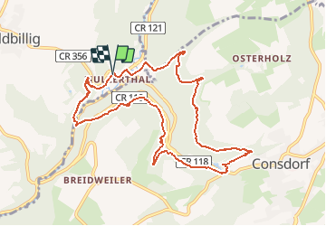
Tocht Te voet van 9,7 km beschikbaar op Onbekend, Canton Echternach, Waldbillig. Deze tocht wordt voorgesteld door zepp63.
Beschrijving
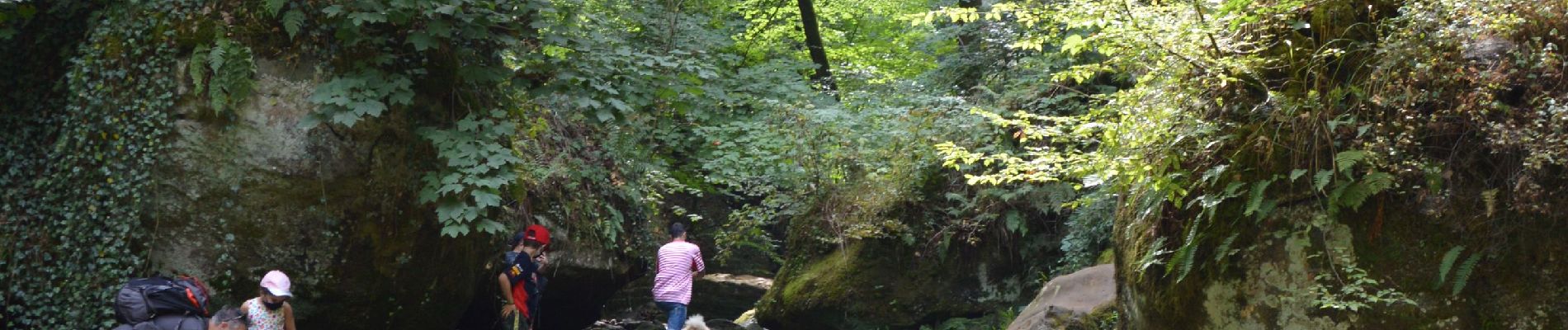
Magnifique rando au départ du parking du camping, vers la cascade, puis parcours dans les bois superbe, dépaysement garanti
Plaatsbepaling
Land:
Luxembourg
Regio :
Onbekend
Departement/Provincie :
Canton Echternach
Gemeente :
Waldbillig
Locatie:
Unknown
Vertrek:(Dec)
Vertrek:(UTM)
306130 ; 5518849 (32U) N.
Opmerkingen
Wandeltochten in de omgeving
![Tocht Stappen Waldbillig - 2024-08-10_15h10m00_Sentier_local_-_W4 - Photo](https://media.geolcdn.com/t/375/260/d315698e-faa8-4cbd-932a-8a7221249730.jpg&format=jpg&maxdim=2)
![Stappen Stappen](https://static1.geolcdn.com/sitytour/trail-icons/101.png)
2024-08-10_15h10m00_Sentier_local_-_W4
Stappen
Medium
(1)
Waldbillig,
Onbekend,
Canton Echternach,
Luxembourg
![](/images/other/stat-length.png)
6,2 km | 7,8 km-effort
1h 45min
![](https://static1.geolcdn.com/siteimages/upload/files/16400158638029165_repeat_loop_refresh_sync_direction_icon.png)
Ja
![Tocht Stappen Consdorf - 2023-06-19_09h33m43_Sentier_local_-_C6 - Photo](https://media.geolcdn.com/t/375/260/1a93b691-9fc1-4ff8-ae1a-57fcf6e1418e.jpg&format=jpg&maxdim=2)
![Stappen Stappen](https://static1.geolcdn.com/sitytour/trail-icons/101.png)
2023-06-19_09h33m43_Sentier_local_-_C6
Stappen
Medium
(1)
Consdorf,
Onbekend,
Canton Echternach,
Luxembourg
![](/images/other/stat-length.png)
5,8 km | 7,3 km-effort
1h 39min
![](https://static1.geolcdn.com/siteimages/upload/files/16400158638029165_repeat_loop_refresh_sync_direction_icon.png)
Ja
![Tocht Stappen Consdorf - 2023-06-13_20h43m48_Sentier_local_-_C2 - Photo](https://media.geolcdn.com/t/375/260/0cc79ac2-8683-4672-970a-cfe76e408507.jpg&format=jpg&maxdim=2)
![Stappen Stappen](https://static1.geolcdn.com/sitytour/trail-icons/101.png)
2023-06-13_20h43m48_Sentier_local_-_C2
Stappen
Gemakkelijk
(1)
Consdorf,
Onbekend,
Canton Echternach,
Luxembourg
![](/images/other/stat-length.png)
4,2 km | 5,5 km-effort
1h 15min
![](https://static1.geolcdn.com/siteimages/upload/files/16400158638029165_repeat_loop_refresh_sync_direction_icon.png)
Ja
![Tocht Stappen Consdorf - 2023-06-13_20h03m09_Circuit_auto-pdestre_Consdorf_-_Mullerthal - Photo](https://media.geolcdn.com/t/375/260/43e83e22-9e28-4a45-bf58-3588aa9e8a2f.jpg&format=jpg&maxdim=2)
![Stappen Stappen](https://static1.geolcdn.com/sitytour/trail-icons/101.png)
2023-06-13_20h03m09_Circuit_auto-pdestre_Consdorf_-_Mullerthal
Stappen
Medium
(2)
Consdorf,
Onbekend,
Canton Echternach,
Luxembourg
![](/images/other/stat-length.png)
9 km | 12,3 km-effort
2h 48min
![](https://static1.geolcdn.com/siteimages/upload/files/16400158638029165_repeat_loop_refresh_sync_direction_icon.png)
Ja
![Tocht Stappen Berdorf - Berdorf - B2 - Müllerthal - Photo](https://media.geolcdn.com/t/375/260/517daf86-eb8b-412e-9a7e-d0a346807e81.jpg&format=jpg&maxdim=2)
![Stappen Stappen](https://static1.geolcdn.com/sitytour/trail-icons/101.png)
Berdorf - B2 - Müllerthal
Stappen
Medium
(2)
Berdorf,
Onbekend,
Canton Echternach,
Luxembourg
![](/images/other/stat-length.png)
6,7 km | 8,5 km-effort
1h 35min
![](https://static1.geolcdn.com/siteimages/upload/files/16400158638029165_repeat_loop_refresh_sync_direction_icon.png)
Ja
![Tocht Stappen Beaufort - 2021-07-05_20h10m00_gpx-file (1) - Photo](https://media.geolcdn.com/t/375/260/9b40ebf8-55f0-408d-8504-76ef1490c879.jpg&format=jpg&maxdim=2)
![Stappen Stappen](https://static1.geolcdn.com/sitytour/trail-icons/101.png)
2021-07-05_20h10m00_gpx-file (1)
Stappen
Medium
(1)
Beaufort,
Onbekend,
Canton Echternach,
Luxembourg
![](/images/other/stat-length.png)
10,6 km | 13,6 km-effort
3h 5min
![](https://static1.geolcdn.com/siteimages/upload/files/16400158638029165_repeat_loop_refresh_sync_direction_icon.png)
Ja
![Tocht Stappen Waldbillig - Mullerthal randonnée magnifique - Photo](https://media.geolcdn.com/t/375/260/3f58fb00-23e0-4e5f-be44-94a05c44c601.jpg&format=jpg&maxdim=2)
![Stappen Stappen](https://static1.geolcdn.com/sitytour/trail-icons/101.png)
Mullerthal randonnée magnifique
Stappen
Moeilijk
(4)
Waldbillig,
Onbekend,
Canton Echternach,
Luxembourg
![](/images/other/stat-length.png)
9,3 km | 12,9 km-effort
4h 21min
![](https://static1.geolcdn.com/siteimages/upload/files/16400158638029165_repeat_loop_refresh_sync_direction_icon.png)
Ja
![Tocht Stappen Consdorf - 2023-06-21_17h04m10_Sentier_local_-_C1 (1) - Photo](https://media.geolcdn.com/t/375/260/67bec963-192a-46c1-a89d-070dac0d9ebc.jpg&format=jpg&maxdim=2)
![Stappen Stappen](https://static1.geolcdn.com/sitytour/trail-icons/101.png)
2023-06-21_17h04m10_Sentier_local_-_C1 (1)
Stappen
Gemakkelijk
(1)
Consdorf,
Onbekend,
Canton Echternach,
Luxembourg
![](/images/other/stat-length.png)
1,9 km | 2,5 km-effort
34min
![](https://static1.geolcdn.com/siteimages/upload/files/16400158638029165_repeat_loop_refresh_sync_direction_icon.png)
Ja
![Tocht Stappen Berdorf - 2023-06-03_18h17m36_Sentier_local_-_B8 - Photo](https://media.geolcdn.com/t/375/260/7a8870ac-d558-4a39-b7c2-bdeb26e936c0.jpg&format=jpg&maxdim=2)
![Stappen Stappen](https://static1.geolcdn.com/sitytour/trail-icons/101.png)
2023-06-03_18h17m36_Sentier_local_-_B8
Stappen
Medium
(2)
Berdorf,
Onbekend,
Canton Echternach,
Luxembourg
![](/images/other/stat-length.png)
11,7 km | 15 km-effort
3h 24min
![](https://static1.geolcdn.com/siteimages/upload/files/16400158638029165_repeat_loop_refresh_sync_direction_icon.png)
Ja