![](/images/other/stat-length.png)
![Tocht Stappen Arnaud-Guilhem - Arnaud-Guilhem - Sentier des Légendes - Photo](https://media.geolcdn.com/t/1900/400/6b791e33-57f9-4427-ad65-f192f26dd0f7.jpg&format=pjpeg&maxdim=2)
Arnaud-Guilhem - Sentier des Légendes
olivicol
Gebruiker
![Lengte](/images/other/stat-length.png)
Lengte
6,6 km
![Max. hoogte](https://static1.geolcdn.com/siteimages/upload/files/1508320355ic_sort_altitude_max_24dp.png)
Max. hoogte
423 m
![Positief hoogteverschil](https://static1.geolcdn.com/siteimages/upload/files/1508320355ic_sort_den_pos_24dp.png)
Positief hoogteverschil
150 m
![Km-Effort](/images/other/stat-length.png)
Km-Effort
8,6 km
![Min. hoogte](https://static1.geolcdn.com/siteimages/upload/files/1508320355ic_sort_altitude_min_24dp.png)
Min. hoogte
312 m
![Negatief hoogteverschil](https://static1.geolcdn.com/siteimages/upload/files/1508320355ic_sort_den_neg_24dp.png)
Negatief hoogteverschil
148 m
![Boucle](https://static1.geolcdn.com/siteimages/upload/files/16400158638029165_repeat_loop_refresh_sync_direction_icon.png)
Boucle
Ja
Datum van aanmaak :
2020-07-21 07:17:19.65
Laatste wijziging :
2022-04-04 15:45:13.208
![Stappen](https://static1.geolcdn.com/sitytour/trail-icons/101.png)
1h29
Moeilijkheid : Heel gemakkelijk
![Scan deze QR-code om de tocht te openen in de SityTrail-applicatie](https://capi.geolives.com/qq0zvz2zws4bq2lad0pu/sitytour/trails/2484323/qr.png?size=200)
Gratisgps-wandelapplicatie
Over ons
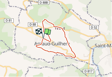
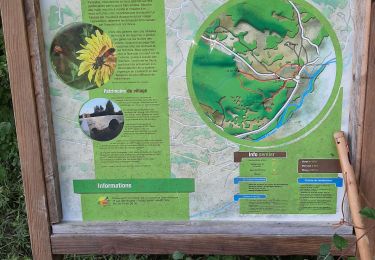
Tocht Stappen van 6,6 km beschikbaar op Occitanië, Haute-Garonne, Arnaud-Guilhem. Deze tocht wordt voorgesteld door olivicol.
Beschrijving
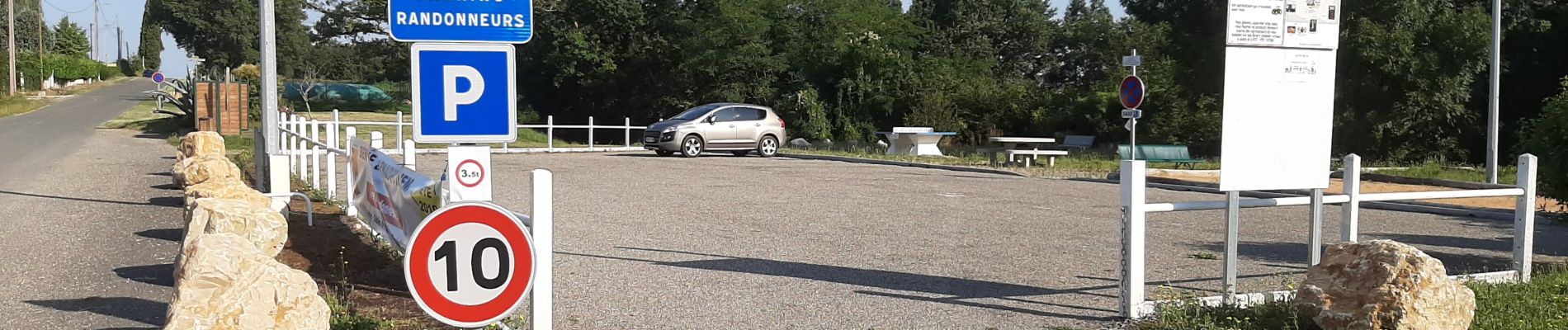
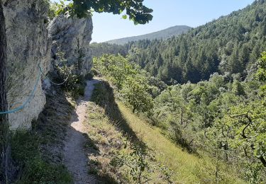
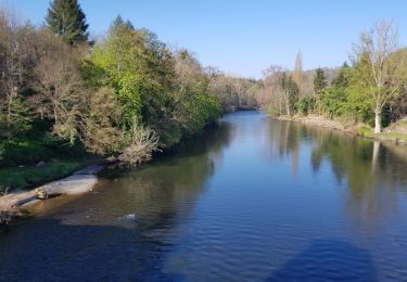
Sentier de 6,60 km. Départ Aire des randonneurs à Arnaud-Guilhem. Vue sur la chaîne des Pyrénées, passage près de 3 lavoirs. Marche facile.
Plaatsbepaling
Land:
France
Regio :
Occitanië
Departement/Provincie :
Haute-Garonne
Gemeente :
Arnaud-Guilhem
Locatie:
Unknown
Vertrek:(Dec)
Vertrek:(UTM)
328724 ; 4778992 (31T) N.
Opmerkingen
Wandeltochten in de omgeving
![Tocht Stappen Laffite-Toupière - Sentier des Crêtes - Auderette - Photo](https://media.geolcdn.com/t/375/260/bec8f625-fd2e-46a0-9da6-10cc20b3bd1b.jpg&format=jpg&maxdim=2)
![Stappen Stappen](https://static1.geolcdn.com/sitytour/trail-icons/101.png)
Sentier des Crêtes - Auderette
Stappen
Heel gemakkelijk
Laffite-Toupière,
Occitanië,
Haute-Garonne,
France
![](/images/other/stat-length.png)
5,2 km | 7,3 km-effort
1h 31min
![](https://static1.geolcdn.com/siteimages/upload/files/16400158638029165_repeat_loop_refresh_sync_direction_icon.png)
Ja
![Tocht Stappen Saint-Martory - Via Garona 2 St Martory Labarthe Inard - Photo](https://media.geolcdn.com/t/375/260/d4b660ed-4bd1-46d3-80ff-c0c93f6db4e7.jpg&format=jpg&maxdim=2)
![Stappen Stappen](https://static1.geolcdn.com/sitytour/trail-icons/101.png)
Via Garona 2 St Martory Labarthe Inard
Stappen
Heel gemakkelijk
Saint-Martory,
Occitanië,
Haute-Garonne,
France
![](/images/other/stat-length.png)
19,4 km | 25 km-effort
6h 55min
![](https://static1.geolcdn.com/siteimages/upload/files/16400158638029165_repeat_loop_refresh_sync_direction_icon.png)
Neen
![Tocht Hybride fiets Salies-du-Salat - lacave - Photo](https://media.geolcdn.com/t/375/260/ext.jpg?maxdim=2&url=https%3A%2F%2Fstatic1.geolcdn.com%2Fsiteimages%2Fupload%2Ffiles%2F1524743154velo.jpg)
![Hybride fiets Hybride fiets](https://static1.geolcdn.com/sitytour/trail-icons/203.png)
lacave
Hybride fiets
Gemakkelijk
Salies-du-Salat,
Occitanië,
Haute-Garonne,
France
![](/images/other/stat-length.png)
18,8 km | 20 km-effort
1h 14min
![](https://static1.geolcdn.com/siteimages/upload/files/16400158638029165_repeat_loop_refresh_sync_direction_icon.png)
Ja
![Tocht Stappen Laffite-Toupière - Lafite toupière court fait 2022 - Photo](https://media.geolcdn.com/t/375/260/ext.jpg?maxdim=2&url=https%3A%2F%2Fstatic1.geolcdn.com%2Fsiteimages%2Fupload%2Ffiles%2F1553511878bg_sport_marche.png)
![Stappen Stappen](https://static1.geolcdn.com/sitytour/trail-icons/101.png)
Lafite toupière court fait 2022
Stappen
Gemakkelijk
Laffite-Toupière,
Occitanië,
Haute-Garonne,
France
![](/images/other/stat-length.png)
5,1 km | 6,9 km-effort
1h 47min
![](https://static1.geolcdn.com/siteimages/upload/files/16400158638029165_repeat_loop_refresh_sync_direction_icon.png)
Ja
![Tocht Stappen Arnaud-Guilhem - Le Lances - Photo](https://media.geolcdn.com/t/375/260/abf0b5d0-4024-42c8-b5f8-06aed7b1f2ab.jpg&format=jpg&maxdim=2)
![Stappen Stappen](https://static1.geolcdn.com/sitytour/trail-icons/101.png)
Le Lances
Stappen
Heel gemakkelijk
Arnaud-Guilhem,
Occitanië,
Haute-Garonne,
France
![](/images/other/stat-length.png)
2,2 km | 3,1 km-effort
48min
![](https://static1.geolcdn.com/siteimages/upload/files/16400158638029165_repeat_loop_refresh_sync_direction_icon.png)
Neen
![Tocht Stappen Laffite-Toupière - Laffite Mancioux la Noue - Photo](https://media.geolcdn.com/t/375/260/59e9e050-61ec-4d5c-82f3-6de5ad5009b3.jpg&format=jpg&maxdim=2)
![Stappen Stappen](https://static1.geolcdn.com/sitytour/trail-icons/101.png)
Laffite Mancioux la Noue
Stappen
Heel gemakkelijk
Laffite-Toupière,
Occitanië,
Haute-Garonne,
France
![](/images/other/stat-length.png)
4,3 km | 5 km-effort
1h 2min
![](https://static1.geolcdn.com/siteimages/upload/files/16400158638029165_repeat_loop_refresh_sync_direction_icon.png)
Ja
![Tocht Stappen Saint-Martory - 31_Saint Martory - Photo](https://media.geolcdn.com/t/375/260/ext.jpg?maxdim=2&url=https%3A%2F%2Fstatic1.geolcdn.com%2Fsiteimages%2Fupload%2Ffiles%2F1553511878bg_sport_marche.png)
![Stappen Stappen](https://static1.geolcdn.com/sitytour/trail-icons/101.png)
31_Saint Martory
Stappen
Medium
Saint-Martory,
Occitanië,
Haute-Garonne,
France
![](/images/other/stat-length.png)
14,7 km | 22 km-effort
3h 58min
![](https://static1.geolcdn.com/siteimages/upload/files/16400158638029165_repeat_loop_refresh_sync_direction_icon.png)
Ja
![Tocht Mountainbike Auzas - Cazeneuve Aulon - Photo](https://media.geolcdn.com/t/375/260/ext.jpg?maxdim=2&url=https%3A%2F%2Fstatic1.geolcdn.com%2Fsiteimages%2Fupload%2Ffiles%2F1524743154velo.jpg)
![Mountainbike Mountainbike](https://static1.geolcdn.com/sitytour/trail-icons/202.png)
Cazeneuve Aulon
Mountainbike
Medium
Auzas,
Occitanië,
Haute-Garonne,
France
![](/images/other/stat-length.png)
16,6 km | 22 km-effort
1h 30min
![](https://static1.geolcdn.com/siteimages/upload/files/16400158638029165_repeat_loop_refresh_sync_direction_icon.png)
Ja
![Tocht Stappen Auzas - Cazeneuve Aulon - Photo](https://media.geolcdn.com/t/375/260/ext.jpg?maxdim=2&url=https%3A%2F%2Fstatic1.geolcdn.com%2Fsiteimages%2Fupload%2Ffiles%2F1553511878bg_sport_marche.png)
![Stappen Stappen](https://static1.geolcdn.com/sitytour/trail-icons/101.png)
Cazeneuve Aulon
Stappen
Moeilijk
Auzas,
Occitanië,
Haute-Garonne,
France
![](/images/other/stat-length.png)
16,6 km | 22 km-effort
4h 0min
![](https://static1.geolcdn.com/siteimages/upload/files/16400158638029165_repeat_loop_refresh_sync_direction_icon.png)
Ja