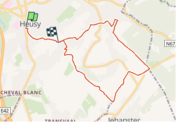
![](/images/other/stat-length.png)
![Tocht Stappen Verviers - 2020-07-20_18h59m43_Cirkwi-Heusy__Ramecroix - Photo](https://media.geolcdn.com/t/1900/400/ext.pjpeg?maxdim=2&url=https%3A%2F%2Fstatic1.geolcdn.com%2Fsiteimages%2Fupload%2Ffiles%2F1553511878bg_sport_marche.png)
2020-07-20_18h59m43_Cirkwi-Heusy__Ramecroix
didier.cavillot
Gebruiker
![Lengte](/images/other/stat-length.png)
![Max. hoogte](https://static1.geolcdn.com/siteimages/upload/files/1508320355ic_sort_altitude_max_24dp.png)
![Positief hoogteverschil](https://static1.geolcdn.com/siteimages/upload/files/1508320355ic_sort_den_pos_24dp.png)
![Km-Effort](/images/other/stat-length.png)
![Min. hoogte](https://static1.geolcdn.com/siteimages/upload/files/1508320355ic_sort_altitude_min_24dp.png)
![Negatief hoogteverschil](https://static1.geolcdn.com/siteimages/upload/files/1508320355ic_sort_den_neg_24dp.png)
![Boucle](https://static1.geolcdn.com/siteimages/upload/files/16400158638029165_repeat_loop_refresh_sync_direction_icon.png)
![Stappen](https://static1.geolcdn.com/sitytour/trail-icons/101.png)
2h18
Moeilijkheid : Medium
![Scan deze QR-code om de tocht te openen in de SityTrail-applicatie](https://capi.geolives.com/qq0zvz2zws4bq2lad0pu/sitytour/trails/2483848/qr.png?size=200)
Gratisgps-wandelapplicatie
Over ons
Tocht Stappen van 8,5 km beschikbaar op Wallonië, Luik, Verviers. Deze tocht wordt voorgesteld door didier.cavillot.
Beschrijving
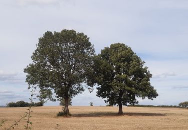
Au vu de l’actualité sanitaire et politique de notre pays, et suivant la décision fédérale du 12/03/20, l'itinéraire n'a pu être entretenu. Celui-ci, peut donc possiblement être en mauvais état. L'itinéraire sera réaménagé dès que possible. La promenade parcourt une très belle vallée, bien calme, qui constitue une partie importante de la ceinture verte.
Plaatsbepaling
Opmerkingen
Wandeltochten in de omgeving
![Tocht Stappen Theux - Theux - Natura 2000, des sites qui valent le détour - LG22 - Photo](https://media.geolcdn.com/t/375/260/ext.jpg?maxdim=2&url=https%3A%2F%2Fservices.sitytrail.com%2FGeolivesWS%2FDownloadMedia.ashx%3FTrailID%3D612638%26Media%3D53072597-f13a-4b1e-b213-a2c1df094f1f.JPG)
![Stappen Stappen](https://static1.geolcdn.com/sitytour/trail-icons/101.png)
Stappen
![](/images/other/stat-length.png)
![](https://static1.geolcdn.com/siteimages/upload/files/16400158638029165_repeat_loop_refresh_sync_direction_icon.png)
![Tocht Stappen Verviers - Grand vivier - Cossart - Photo](https://media.geolcdn.com/t/375/260/ext.jpg?maxdim=2&url=https%3A%2F%2Fstatic1.geolcdn.com%2Fsiteimages%2Fupload%2Ffiles%2F1553511878bg_sport_marche.png)
![Stappen Stappen](https://static1.geolcdn.com/sitytour/trail-icons/101.png)
Stappen
![](/images/other/stat-length.png)
![](https://static1.geolcdn.com/siteimages/upload/files/16400158638029165_repeat_loop_refresh_sync_direction_icon.png)
![Stappen Stappen](https://static1.geolcdn.com/sitytour/trail-icons/101.png)
Stappen
![](/images/other/stat-length.png)
![](https://static1.geolcdn.com/siteimages/upload/files/16400158638029165_repeat_loop_refresh_sync_direction_icon.png)
![Stappen Stappen](https://static1.geolcdn.com/sitytour/trail-icons/101.png)
Stappen
![](/images/other/stat-length.png)
![](https://static1.geolcdn.com/siteimages/upload/files/16400158638029165_repeat_loop_refresh_sync_direction_icon.png)
![Tocht Stappen Limburg - 20200606 - Hèvremont 8 Km - Photo](https://media.geolcdn.com/t/375/260/8311f513-ce09-455a-b0ac-51a7423b07df.jpg&format=jpg&maxdim=2)
![Stappen Stappen](https://static1.geolcdn.com/sitytour/trail-icons/101.png)
Stappen
![](/images/other/stat-length.png)
![](https://static1.geolcdn.com/siteimages/upload/files/16400158638029165_repeat_loop_refresh_sync_direction_icon.png)
![Tocht Stappen Herve - Grand-Rechain 🎅🎄 - Photo](https://media.geolcdn.com/t/375/260/4ac1b489-a981-486f-9575-913bd20e929a.jpg&format=jpg&maxdim=2)
![Stappen Stappen](https://static1.geolcdn.com/sitytour/trail-icons/101.png)
Stappen
![](/images/other/stat-length.png)
![](https://static1.geolcdn.com/siteimages/upload/files/16400158638029165_repeat_loop_refresh_sync_direction_icon.png)
![Te voet Te voet](https://static1.geolcdn.com/sitytour/trail-icons/100.png)
Te voet
![](/images/other/stat-length.png)
![](https://static1.geolcdn.com/siteimages/upload/files/16400158638029165_repeat_loop_refresh_sync_direction_icon.png)
![Tocht Trail Theux - Extratrail - Theux (blauw) 18 km - Photo](https://media.geolcdn.com/t/375/260/0911e17e-920d-442e-8495-16fc909f2c4f.jpg&format=jpg&maxdim=2)
![Trail Trail](https://static1.geolcdn.com/sitytour/trail-icons/104.png)
Trail
![](/images/other/stat-length.png)
![](https://static1.geolcdn.com/siteimages/upload/files/16400158638029165_repeat_loop_refresh_sync_direction_icon.png)
![Tocht Stappen Verviers - Stembert . les Roudoudous . Stembert - Photo](https://media.geolcdn.com/t/375/260/83013b57-22fc-4f55-b86f-1cd16e0258d4.jpg&format=jpg&maxdim=2)
![Stappen Stappen](https://static1.geolcdn.com/sitytour/trail-icons/101.png)
Stappen
![](/images/other/stat-length.png)
![](https://static1.geolcdn.com/siteimages/upload/files/16400158638029165_repeat_loop_refresh_sync_direction_icon.png)