![](/images/other/stat-length.png)
![Tocht Stappen Vilcey-sur-Trey - Vilcey sur Trey - Photo](https://media.geolcdn.com/t/1900/400/60becd6f-0284-4664-bb7c-b37cff85d5cd.jpg&format=pjpeg&maxdim=2)
Vilcey sur Trey
Greg813
Gebruiker
![Lengte](/images/other/stat-length.png)
Lengte
17,2 km
![Max. hoogte](https://static1.geolcdn.com/siteimages/upload/files/1508320355ic_sort_altitude_max_24dp.png)
Max. hoogte
362 m
![Positief hoogteverschil](https://static1.geolcdn.com/siteimages/upload/files/1508320355ic_sort_den_pos_24dp.png)
Positief hoogteverschil
340 m
![Km-Effort](/images/other/stat-length.png)
Km-Effort
22 km
![Min. hoogte](https://static1.geolcdn.com/siteimages/upload/files/1508320355ic_sort_altitude_min_24dp.png)
Min. hoogte
226 m
![Negatief hoogteverschil](https://static1.geolcdn.com/siteimages/upload/files/1508320355ic_sort_den_neg_24dp.png)
Negatief hoogteverschil
347 m
![Boucle](https://static1.geolcdn.com/siteimages/upload/files/16400158638029165_repeat_loop_refresh_sync_direction_icon.png)
Boucle
Ja
Datum van aanmaak :
2020-07-17 14:09:39.53
Laatste wijziging :
2020-07-21 16:27:29.146
![Stappen](https://static1.geolcdn.com/sitytour/trail-icons/101.png)
4h50
Moeilijkheid : Moeilijk
![Scan deze QR-code om de tocht te openen in de SityTrail-applicatie](https://capi.geolives.com/qq0zvz2zws4bq2lad0pu/sitytour/trails/2479276/qr.png?size=200)
Gratisgps-wandelapplicatie
Over ons
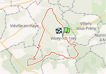
Tocht Stappen van 17,2 km beschikbaar op Grand Est, Meurthe-et-Moselle, Vilcey-sur-Trey. Deze tocht wordt voorgesteld door Greg813.
Beschrijving
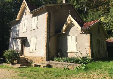
Randonnée dans les forêts jouxtant Vilcey sur Trey.
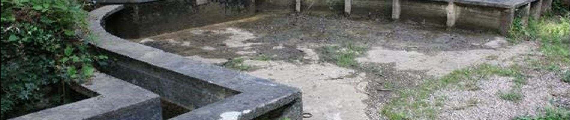
Passage par les vestiges des positions allemandes de la première guerre mondiale.
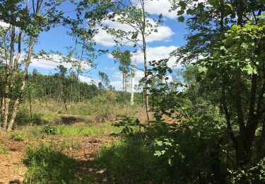
Les chemins sont assez dégagés et bien entretenus.
Plaatsbepaling
Land:
France
Regio :
Grand Est
Departement/Provincie :
Meurthe-et-Moselle
Gemeente :
Vilcey-sur-Trey
Locatie:
Unknown
Vertrek:(Dec)
Vertrek:(UTM)
717681 ; 5424491 (31U) N.
Opmerkingen
Wandeltochten in de omgeving
![Tocht Mountainbike Pont-à-Mousson - Pose balises V3 - Photo](https://media.geolcdn.com/t/375/260/ext.jpg?maxdim=2&url=https%3A%2F%2Fstatic1.geolcdn.com%2Fsiteimages%2Fupload%2Ffiles%2F1524743154velo.jpg)
![Mountainbike Mountainbike](https://static1.geolcdn.com/sitytour/trail-icons/202.png)
Pose balises V3
Mountainbike
Medium
(1)
Pont-à-Mousson,
Grand Est,
Meurthe-et-Moselle,
France
![](/images/other/stat-length.png)
19,9 km | 26 km-effort
2h 1min
![](https://static1.geolcdn.com/siteimages/upload/files/16400158638029165_repeat_loop_refresh_sync_direction_icon.png)
Neen
![Tocht Stappen Montauville - AUDAX PONT A MOUSSON SI SEC - Photo](https://media.geolcdn.com/t/375/260/ext.jpg?maxdim=2&url=https%3A%2F%2Fstatic1.geolcdn.com%2Fsiteimages%2Fupload%2Ffiles%2F1553511878bg_sport_marche.png)
![Stappen Stappen](https://static1.geolcdn.com/sitytour/trail-icons/101.png)
AUDAX PONT A MOUSSON SI SEC
Stappen
Moeilijk
(1)
Montauville,
Grand Est,
Meurthe-et-Moselle,
France
![](/images/other/stat-length.png)
50 km | 60 km-effort
13h 35min
![](https://static1.geolcdn.com/siteimages/upload/files/16400158638029165_repeat_loop_refresh_sync_direction_icon.png)
Ja
![Tocht Stappen Prény - Forêt de Preny dévastée quelle dommage - Photo](https://media.geolcdn.com/t/375/260/1f50b1f7-4c8a-4c2b-b85a-6e1416c0eb49.jpg&format=jpg&maxdim=2)
![Stappen Stappen](https://static1.geolcdn.com/sitytour/trail-icons/101.png)
Forêt de Preny dévastée quelle dommage
Stappen
Medium
Prény,
Grand Est,
Meurthe-et-Moselle,
France
![](/images/other/stat-length.png)
7,4 km | 9,7 km-effort
1h 14min
![](https://static1.geolcdn.com/siteimages/upload/files/16400158638029165_repeat_loop_refresh_sync_direction_icon.png)
Neen
![Tocht Mountainbike Vilcey-sur-Trey - Les villages du Saillant de St-Mihiel, aux portes de Pontà-Mousson. - Circuit n° 12 - Photo](https://media.geolcdn.com/t/375/260/ext.jpg?maxdim=2&url=https%3A%2F%2Fservices.sitytrail.com%2FGeolivesWS%2FDownloadMedia.ashx%3FTrailID%3D111742%26Media%3D8148_6.jpg)
![Mountainbike Mountainbike](https://static1.geolcdn.com/sitytour/trail-icons/202.png)
Les villages du Saillant de St-Mihiel, aux portes de Pontà-Mousson. - Circuit...
Mountainbike
Moeilijk
Vilcey-sur-Trey,
Grand Est,
Meurthe-et-Moselle,
France
![](/images/other/stat-length.png)
47 km | 56 km-effort
2h 30min
![](https://static1.geolcdn.com/siteimages/upload/files/16400158638029165_repeat_loop_refresh_sync_direction_icon.png)
Ja
![Tocht Stappen Maidières - Maidieres - Boucle des vergers - variante - Photo](https://media.geolcdn.com/t/375/260/367e0312-9c24-4fe6-924b-4469c90b860d.jpg&format=jpg&maxdim=2)
![Stappen Stappen](https://static1.geolcdn.com/sitytour/trail-icons/101.png)
Maidieres - Boucle des vergers - variante
Stappen
Medium
Maidières,
Grand Est,
Meurthe-et-Moselle,
France
![](/images/other/stat-length.png)
6,4 km | 8,7 km-effort
2h 1min
![](https://static1.geolcdn.com/siteimages/upload/files/16400158638029165_repeat_loop_refresh_sync_direction_icon.png)
Ja
![Tocht Stappen Maidières - Maidières Poterosse chemin de la croix robert GR5 Prochebois - Photo](https://media.geolcdn.com/t/375/260/01bc62b5-49ba-4f4b-9dd0-d4ce4af660a6.jpg&format=jpg&maxdim=2)
![Stappen Stappen](https://static1.geolcdn.com/sitytour/trail-icons/101.png)
Maidières Poterosse chemin de la croix robert GR5 Prochebois
Stappen
Medium
Maidières,
Grand Est,
Meurthe-et-Moselle,
France
![](/images/other/stat-length.png)
4 km | 5,8 km-effort
1h 30min
![](https://static1.geolcdn.com/siteimages/upload/files/16400158638029165_repeat_loop_refresh_sync_direction_icon.png)
Ja
![Tocht Stappen Montauville - montauville - père hilarion - Photo](https://media.geolcdn.com/t/375/260/15ceac34-5410-4401-901f-eb77da2fe81a.jpg&format=jpg&maxdim=2)
![Stappen Stappen](https://static1.geolcdn.com/sitytour/trail-icons/101.png)
montauville - père hilarion
Stappen
Gemakkelijk
Montauville,
Grand Est,
Meurthe-et-Moselle,
France
![](/images/other/stat-length.png)
10,2 km | 12,8 km-effort
3h 56min
![](https://static1.geolcdn.com/siteimages/upload/files/16400158638029165_repeat_loop_refresh_sync_direction_icon.png)
Ja
![Tocht Stappen Montauville - Le père Hilarion Montauville - Photo](https://media.geolcdn.com/t/375/260/8bcf192c-1c36-487f-9601-fef1b0fbc29c.jpg&format=jpg&maxdim=2)
![Stappen Stappen](https://static1.geolcdn.com/sitytour/trail-icons/101.png)
Le père Hilarion Montauville
Stappen
Gemakkelijk
Montauville,
Grand Est,
Meurthe-et-Moselle,
France
![](/images/other/stat-length.png)
6,6 km | 8,6 km-effort
2h 44min
![](https://static1.geolcdn.com/siteimages/upload/files/16400158638029165_repeat_loop_refresh_sync_direction_icon.png)
Ja
![Tocht Stappen Montauville - Bois le Prêtre Le 09/09/2023 - Photo](https://media.geolcdn.com/t/375/260/0218d1ec-e3d5-42ff-bbd3-74f988efec70.jpg&format=jpg&maxdim=2)
![Stappen Stappen](https://static1.geolcdn.com/sitytour/trail-icons/101.png)
Bois le Prêtre Le 09/09/2023
Stappen
Medium
(1)
Montauville,
Grand Est,
Meurthe-et-Moselle,
France
![](/images/other/stat-length.png)
9,9 km | 12,3 km-effort
2h 30min
![](https://static1.geolcdn.com/siteimages/upload/files/16400158638029165_repeat_loop_refresh_sync_direction_icon.png)
Ja