![](/images/other/stat-length.png)
Bouin-Plumoison Cyclisme
Sportiva France
En pleine nature
![Lengte](/images/other/stat-length.png)
Lengte
26 km
![Max. hoogte](https://static1.geolcdn.com/siteimages/upload/files/1508320355ic_sort_altitude_max_24dp.png)
Max. hoogte
134 m
![Positief hoogteverschil](https://static1.geolcdn.com/siteimages/upload/files/1508320355ic_sort_den_pos_24dp.png)
Positief hoogteverschil
406 m
![Km-Effort](/images/other/stat-length.png)
Km-Effort
31 km
![Min. hoogte](https://static1.geolcdn.com/siteimages/upload/files/1508320355ic_sort_altitude_min_24dp.png)
Min. hoogte
19 m
![Negatief hoogteverschil](https://static1.geolcdn.com/siteimages/upload/files/1508320355ic_sort_den_neg_24dp.png)
Negatief hoogteverschil
406 m
![Boucle](https://static1.geolcdn.com/siteimages/upload/files/16400158638029165_repeat_loop_refresh_sync_direction_icon.png)
Boucle
Ja
Datum van aanmaak :
2020-07-12 16:58:38.531
Laatste wijziging :
2020-07-14 08:04:43.494
![Mountainbike](https://static1.geolcdn.com/sitytour/trail-icons/202.png)
2h03
Moeilijkheid : Medium
![Scan deze QR-code om de tocht te openen in de SityTrail-applicatie](https://capi.geolives.com/qq0zvz2zws4bq2lad0pu/sitytour/trails/2472672/qr.png?size=200)
Gratisgps-wandelapplicatie
Over ons
Tocht Mountainbike van 26 km beschikbaar op Hauts-de-France, Pas-de-Calais, Bouin-Plumoison. Deze tocht wordt voorgesteld door Sportiva France.
Beschrijving
Beau parcours de 25 km avec des montée et des descentes super.
Plaatsbepaling
Land:
France
Regio :
Hauts-de-France
Departement/Provincie :
Pas-de-Calais
Gemeente :
Bouin-Plumoison
Locatie:
Unknown
Vertrek:(Dec)
Vertrek:(UTM)
428446 ; 5581486 (31U) N.
Opmerkingen
Wandeltochten in de omgeving
![Tocht Mountainbike Marconnelle - Balade historique - Forêt D'HESDIN - Photo](https://media.geolcdn.com/t/375/260/784cdf1a-cb06-48cd-8c7a-7933ed6eb0b5.jpg&format=jpg&maxdim=2)
![Mountainbike Mountainbike](https://static1.geolcdn.com/sitytour/trail-icons/202.png)
Balade historique - Forêt D'HESDIN
Mountainbike
Medium
Marconnelle,
Hauts-de-France,
Pas-de-Calais,
France
![](/images/other/stat-length.png)
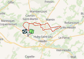
19,1 km | 22 km-effort
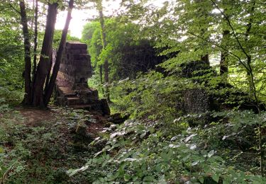
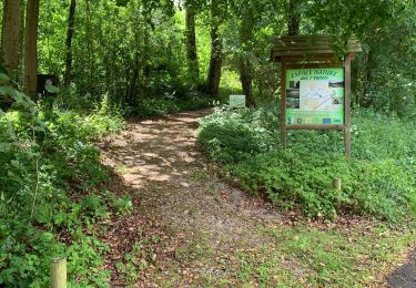
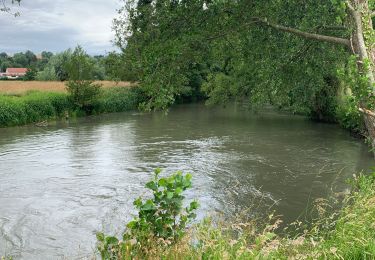
1h 36min
![](https://static1.geolcdn.com/siteimages/upload/files/16400158638029165_repeat_loop_refresh_sync_direction_icon.png)
Ja
![Tocht Mountainbike Bouin-Plumoison - activity_5286630291 - Photo](https://media.geolcdn.com/t/375/260/a56f6788-3a1e-4309-8805-e64d5c010517.jpg&format=jpg&maxdim=2)
![Mountainbike Mountainbike](https://static1.geolcdn.com/sitytour/trail-icons/202.png)
activity_5286630291
Mountainbike
Medium
Bouin-Plumoison,
Hauts-de-France,
Pas-de-Calais,
France
![](/images/other/stat-length.png)
30 km | 36 km-effort
2h 24min
![](https://static1.geolcdn.com/siteimages/upload/files/16400158638029165_repeat_loop_refresh_sync_direction_icon.png)
Ja
![Mountainbike Mountainbike](https://static1.geolcdn.com/sitytour/trail-icons/202.png)
activity_5271978984
Mountainbike
Medium
Bouin-Plumoison,
Hauts-de-France,
Pas-de-Calais,
France
![](/images/other/stat-length.png)
19,7 km | 24 km-effort
1h 34min
![](https://static1.geolcdn.com/siteimages/upload/files/16400158638029165_repeat_loop_refresh_sync_direction_icon.png)
Ja
![Tocht Stappen Marconne - Balade biodiversité - Photo](https://media.geolcdn.com/t/375/260/e25f1574-f05d-40cd-a8f5-428f91e1f05f.jpg&format=jpg&maxdim=2)
![Stappen Stappen](https://static1.geolcdn.com/sitytour/trail-icons/101.png)
Balade biodiversité
Stappen
Medium
Marconne,
Hauts-de-France,
Pas-de-Calais,
France
![](/images/other/stat-length.png)
1 km | 1,4 km-effort
20min
![](https://static1.geolcdn.com/siteimages/upload/files/16400158638029165_repeat_loop_refresh_sync_direction_icon.png)
Ja
![Tocht Stappen Huby-Saint-Leu - Huby 3 matin - Photo](https://media.geolcdn.com/t/375/260/ext.jpg?maxdim=2&url=https%3A%2F%2Fstatic1.geolcdn.com%2Fsiteimages%2Fupload%2Ffiles%2F1553511878bg_sport_marche.png)
![Stappen Stappen](https://static1.geolcdn.com/sitytour/trail-icons/101.png)
Huby 3 matin
Stappen
Medium
Huby-Saint-Leu,
Hauts-de-France,
Pas-de-Calais,
France
![](/images/other/stat-length.png)
5,9 km | 8,2 km-effort
2h 53min
![](https://static1.geolcdn.com/siteimages/upload/files/16400158638029165_repeat_loop_refresh_sync_direction_icon.png)
Ja
![Tocht Stappen Huby-Saint-Leu - Huby 1 - Photo](https://media.geolcdn.com/t/375/260/ext.jpg?maxdim=2&url=https%3A%2F%2Fstatic1.geolcdn.com%2Fsiteimages%2Fupload%2Ffiles%2F1553511878bg_sport_marche.png)
![Stappen Stappen](https://static1.geolcdn.com/sitytour/trail-icons/101.png)
Huby 1
Stappen
Medium
Huby-Saint-Leu,
Hauts-de-France,
Pas-de-Calais,
France
![](/images/other/stat-length.png)
6,1 km | 6,6 km-effort
2h 22min
![](https://static1.geolcdn.com/siteimages/upload/files/16400158638029165_repeat_loop_refresh_sync_direction_icon.png)
Ja
![Mountainbike Mountainbike](https://static1.geolcdn.com/sitytour/trail-icons/202.png)
activity_5151378101
Mountainbike
Heel gemakkelijk
Maresquel-Ecquemicourt,
Hauts-de-France,
Pas-de-Calais,
France
![](/images/other/stat-length.png)
3 km | 3,2 km-effort
18min
![](https://static1.geolcdn.com/siteimages/upload/files/16400158638029165_repeat_loop_refresh_sync_direction_icon.png)
Ja
![Tocht Mountainbike Marconnelle - activity_5121487164 - Photo](https://media.geolcdn.com/t/375/260/ext.jpg?maxdim=2&url=https%3A%2F%2Fstatic1.geolcdn.com%2Fsiteimages%2Fupload%2Ffiles%2F1524743154velo.jpg)
![Mountainbike Mountainbike](https://static1.geolcdn.com/sitytour/trail-icons/202.png)
activity_5121487164
Mountainbike
Medium
Marconnelle,
Hauts-de-France,
Pas-de-Calais,
France
![](/images/other/stat-length.png)
18,6 km | 22 km-effort
Onbekend
![](https://static1.geolcdn.com/siteimages/upload/files/16400158638029165_repeat_loop_refresh_sync_direction_icon.png)
Ja
![Tocht Mountainbike Marconnelle - activity_5081284610 - Photo](https://media.geolcdn.com/t/375/260/ext.jpg?maxdim=2&url=https%3A%2F%2Fstatic1.geolcdn.com%2Fsiteimages%2Fupload%2Ffiles%2F1524743154velo.jpg)
![Mountainbike Mountainbike](https://static1.geolcdn.com/sitytour/trail-icons/202.png)
activity_5081284610
Mountainbike
Medium
Marconnelle,
Hauts-de-France,
Pas-de-Calais,
France
![](/images/other/stat-length.png)
10,3 km | 12,3 km-effort
49min
![](https://static1.geolcdn.com/siteimages/upload/files/16400158638029165_repeat_loop_refresh_sync_direction_icon.png)
Ja