![](/images/other/stat-length.png)
![Tocht Noords wandelen Le Teich - Au Teich, comme un oiseau sur le sentier du littoral - Photo](https://media.geolcdn.com/t/1900/400/ext.pjpeg?maxdim=2&url=https%3A%2F%2Fstatic1.geolcdn.com%2Fsiteimages%2Fupload%2Ffiles%2F1545311037marcheuse_200dpi.jpg)
Au Teich, comme un oiseau sur le sentier du littoral
denissculier
Gebruiker
![Lengte](/images/other/stat-length.png)
![Max. hoogte](https://static1.geolcdn.com/siteimages/upload/files/1508320355ic_sort_altitude_max_24dp.png)
![Positief hoogteverschil](https://static1.geolcdn.com/siteimages/upload/files/1508320355ic_sort_den_pos_24dp.png)
![Km-Effort](/images/other/stat-length.png)
![Min. hoogte](https://static1.geolcdn.com/siteimages/upload/files/1508320355ic_sort_altitude_min_24dp.png)
![Negatief hoogteverschil](https://static1.geolcdn.com/siteimages/upload/files/1508320355ic_sort_den_neg_24dp.png)
![Boucle](https://static1.geolcdn.com/siteimages/upload/files/16400158638029165_repeat_loop_refresh_sync_direction_icon.png)
![Noords wandelen](https://static1.geolcdn.com/sitytour/trail-icons/102.png)
1h55
Moeilijkheid : Medium
![Scan deze QR-code om de tocht te openen in de SityTrail-applicatie](https://capi.geolives.com/qq0zvz2zws4bq2lad0pu/sitytour/trails/2465232/qr.png?size=200)
Gratisgps-wandelapplicatie
Over ons
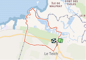
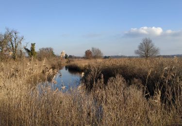
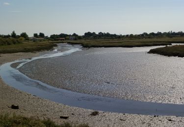
Tocht Noords wandelen van 8,3 km beschikbaar op Nieuw-Aquitanië, Gironde, Le Teich. Deze tocht wordt voorgesteld door denissculier.
Beschrijving
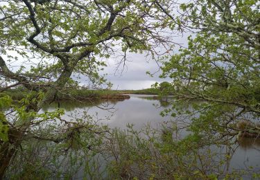
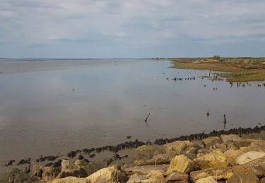
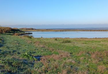
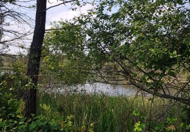
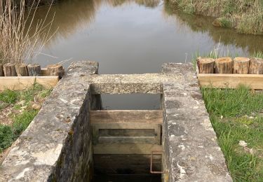
Parcourez le Delta de la Leyre en empruntant le sentier du littoral qui borde la Réserve Ornithologique et découvrez des paysages qui changent au fil des marées et des saisons. De nombreuses espèces d'oiseaux viennent s'abriter, nicher ou se nourrir dans cet espace protégé. Partez à leur rencontre, observez les et laissez vous séduire par leur nature.
Plaatsbepaling
Opmerkingen
Wandeltochten in de omgeving
![Tocht Stappen Gujan-Mestras - tour du parc ornithologique du technicien - Photo](https://media.geolcdn.com/t/375/260/d0bb3a43-e607-426e-870e-c354e35cc861.jpg&format=jpg&maxdim=2)
![Stappen Stappen](https://static1.geolcdn.com/sitytour/trail-icons/101.png)
Stappen
![](/images/other/stat-length.png)
![](https://static1.geolcdn.com/siteimages/upload/files/16400158638029165_repeat_loop_refresh_sync_direction_icon.png)
![Tocht Stappen Audenge - Tour de Graveyron 13.4.23 - Photo](https://media.geolcdn.com/t/375/260/91ba8b9b-4867-4741-a3ba-a7cc99436673.jpg&format=jpg&maxdim=2)
![Stappen Stappen](https://static1.geolcdn.com/sitytour/trail-icons/101.png)
Stappen
![](/images/other/stat-length.png)
![](https://static1.geolcdn.com/siteimages/upload/files/16400158638029165_repeat_loop_refresh_sync_direction_icon.png)
![Tocht Hybride fiets Le Teich - Le Teich - Photo](https://media.geolcdn.com/t/375/260/45c8d39c-9fcb-4ec2-8768-4294b9bee84b.jpg&format=jpg&maxdim=2)
![Hybride fiets Hybride fiets](https://static1.geolcdn.com/sitytour/trail-icons/203.png)
Hybride fiets
![](/images/other/stat-length.png)
![](https://static1.geolcdn.com/siteimages/upload/files/16400158638029165_repeat_loop_refresh_sync_direction_icon.png)
![Tocht Stappen Audenge - Audenge - Tour du domaine de Graveyron - Photo](https://media.geolcdn.com/t/375/260/f67cbc29-97d5-4a3f-9dc0-18eb57246c7e.jpg&format=jpg&maxdim=2)
![Stappen Stappen](https://static1.geolcdn.com/sitytour/trail-icons/101.png)
Stappen
![](/images/other/stat-length.png)
![](https://static1.geolcdn.com/siteimages/upload/files/16400158638029165_repeat_loop_refresh_sync_direction_icon.png)
![Tocht Stappen Le Teich - Parc Ornithologique du Teich - Photo](https://media.geolcdn.com/t/375/260/9cf45162-28f0-4ded-9a21-bff3bda1dbcd.jpg&format=jpg&maxdim=2)
![Stappen Stappen](https://static1.geolcdn.com/sitytour/trail-icons/101.png)
Stappen
![](/images/other/stat-length.png)
![](https://static1.geolcdn.com/siteimages/upload/files/16400158638029165_repeat_loop_refresh_sync_direction_icon.png)
![Tocht Stappen Le Teich - FONTAINE ST JEAN LE TEICH 33 - Photo](https://media.geolcdn.com/t/375/260/7b679e2a-3a5a-4388-864e-b496376e1790.jpg&format=jpg&maxdim=2)
![Stappen Stappen](https://static1.geolcdn.com/sitytour/trail-icons/101.png)
Stappen
![](/images/other/stat-length.png)
![](https://static1.geolcdn.com/siteimages/upload/files/16400158638029165_repeat_loop_refresh_sync_direction_icon.png)
![Tocht Stappen Le Teich - Rando delta de la leyre - Photo](https://media.geolcdn.com/t/375/260/c014c05a-8ab9-4963-a409-e24b10f03be7.jpg&format=jpg&maxdim=2)
![Stappen Stappen](https://static1.geolcdn.com/sitytour/trail-icons/101.png)
Stappen
![](/images/other/stat-length.png)
![](https://static1.geolcdn.com/siteimages/upload/files/16400158638029165_repeat_loop_refresh_sync_direction_icon.png)
![Tocht Stappen Le Teich - 2022-01-16 Tour des plaines du Teich - Photo](https://media.geolcdn.com/t/375/260/c4b203fc-1d1e-4c46-b393-3c2f8459c1d7.jpeg&format=jpg&maxdim=2)
![Stappen Stappen](https://static1.geolcdn.com/sitytour/trail-icons/101.png)
Stappen
![](/images/other/stat-length.png)
![](https://static1.geolcdn.com/siteimages/upload/files/16400158638029165_repeat_loop_refresh_sync_direction_icon.png)
![Tocht Stappen Le Teich - Le Teich - Photo](https://media.geolcdn.com/t/375/260/2564c552-ea7d-4826-ac5e-f94a971dd7f7.jpg&format=jpg&maxdim=2)
![Stappen Stappen](https://static1.geolcdn.com/sitytour/trail-icons/101.png)
Stappen
![](/images/other/stat-length.png)
![](https://static1.geolcdn.com/siteimages/upload/files/16400158638029165_repeat_loop_refresh_sync_direction_icon.png)