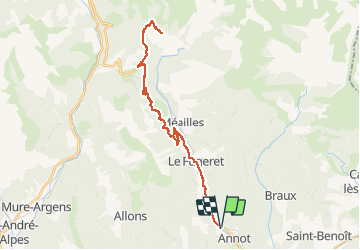
![](/images/other/stat-length.png)
![Tocht Elektrische fiets Annot - Annot - Peresq - Photo](https://media.geolcdn.com/t/1900/400/f9d6f0d3-2fb5-435d-b41a-baaa9e1dae8a.jpg&format=pjpeg&maxdim=2)
Annot - Peresq
lviallet
Gebruiker
![Lengte](/images/other/stat-length.png)
![Max. hoogte](https://static1.geolcdn.com/siteimages/upload/files/1508320355ic_sort_altitude_max_24dp.png)
![Positief hoogteverschil](https://static1.geolcdn.com/siteimages/upload/files/1508320355ic_sort_den_pos_24dp.png)
![Km-Effort](/images/other/stat-length.png)
![Min. hoogte](https://static1.geolcdn.com/siteimages/upload/files/1508320355ic_sort_altitude_min_24dp.png)
![Negatief hoogteverschil](https://static1.geolcdn.com/siteimages/upload/files/1508320355ic_sort_den_neg_24dp.png)
![Boucle](https://static1.geolcdn.com/siteimages/upload/files/16400158638029165_repeat_loop_refresh_sync_direction_icon.png)
![Elektrische fiets](https://static1.geolcdn.com/sitytour/trail-icons/205.png)
2h19
Moeilijkheid : Medium
![Scan deze QR-code om de tocht te openen in de SityTrail-applicatie](https://capi.geolives.com/qq0zvz2zws4bq2lad0pu/sitytour/trails/2457341/qr.png?size=200)
Gratisgps-wandelapplicatie
Over ons
Tocht Elektrische fiets van 38 km beschikbaar op Provence-Alpes-Côte d'Azur, Alpes-de-Haute-Provence, Annot. Deze tocht wordt voorgesteld door lviallet.
Beschrijving
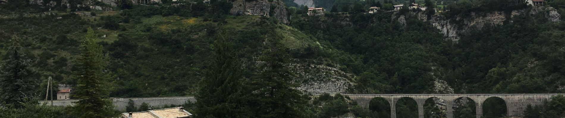
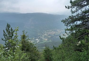
Peresq a 2 habitants qui y vivent toute l'année. Les membres d'une association belge ont achetés et rénovés un grand nombre de ces maisons.
La poste distribue le courrier deux fois par semaines, été comme hiver.
En été, beaucoup de Belges viennent y vivre.
Ce village est un véritable bijoux!
Plaatsbepaling
Opmerkingen
Wandeltochten in de omgeving
![Tocht Te voet Annot - Le Grès d'Annot - Photo](https://media.geolcdn.com/t/375/260/d494c9f4-04f5-4184-be97-f5fea23e1191.jpeg&format=jpg&maxdim=2)
![Te voet Te voet](https://static1.geolcdn.com/sitytour/trail-icons/100.png)
Te voet
![](/images/other/stat-length.png)
![](https://static1.geolcdn.com/siteimages/upload/files/16400158638029165_repeat_loop_refresh_sync_direction_icon.png)
![Tocht Ski randonnée Castellet-lès-Sausses - mourre Frey te tête de travers - Photo](https://media.geolcdn.com/t/375/260/1b767a21-1868-437d-b876-59d00a73f0ab.jpg&format=jpg&maxdim=2)
![Ski randonnée Ski randonnée](https://static1.geolcdn.com/sitytour/trail-icons/503.png)
Ski randonnée
![](/images/other/stat-length.png)
![](https://static1.geolcdn.com/siteimages/upload/files/16400158638029165_repeat_loop_refresh_sync_direction_icon.png)
![Tocht Stappen Annot - J4 Annot - Photo](https://media.geolcdn.com/t/375/260/be9d9d12-b8a6-45a8-bd70-6f8cacf32730.jpg&format=jpg&maxdim=2)
![Stappen Stappen](https://static1.geolcdn.com/sitytour/trail-icons/101.png)
Stappen
![](/images/other/stat-length.png)
![](https://static1.geolcdn.com/siteimages/upload/files/16400158638029165_repeat_loop_refresh_sync_direction_icon.png)
![Stappen Stappen](https://static1.geolcdn.com/sitytour/trail-icons/101.png)
Stappen
![](/images/other/stat-length.png)
![](https://static1.geolcdn.com/siteimages/upload/files/16400158638029165_repeat_loop_refresh_sync_direction_icon.png)
![Tocht Stappen Annot - Rando gastro Roncharel - Photo](https://media.geolcdn.com/t/375/260/4e3f8487-9887-4ec3-94b2-d5bbd50aefe8.jpg&format=jpg&maxdim=2)
![Stappen Stappen](https://static1.geolcdn.com/sitytour/trail-icons/101.png)
Stappen
![](/images/other/stat-length.png)
![](https://static1.geolcdn.com/siteimages/upload/files/16400158638029165_repeat_loop_refresh_sync_direction_icon.png)
![Tocht Stappen Annot - Les grès d'Annot - Photo](https://media.geolcdn.com/t/375/260/ext.jpg?maxdim=2&url=https%3A%2F%2Fstatic1.geolcdn.com%2Fsiteimages%2Fupload%2Ffiles%2F1553511878bg_sport_marche.png)
![Stappen Stappen](https://static1.geolcdn.com/sitytour/trail-icons/101.png)
Stappen
![](/images/other/stat-length.png)
![](https://static1.geolcdn.com/siteimages/upload/files/16400158638029165_repeat_loop_refresh_sync_direction_icon.png)
![Tocht Stappen Castellet-lès-Sausses - Tête de travers et Mourre Frey, du Col du Fam - Photo](https://media.geolcdn.com/t/375/260/a4176451-cb19-4ec9-86ca-b1e3e647aa87.jpg&format=jpg&maxdim=2)
![Stappen Stappen](https://static1.geolcdn.com/sitytour/trail-icons/101.png)
Stappen
![](/images/other/stat-length.png)
![](https://static1.geolcdn.com/siteimages/upload/files/16400158638029165_repeat_loop_refresh_sync_direction_icon.png)
![Tocht Stappen Annot - Rando bleue - Photo](https://media.geolcdn.com/t/375/260/94ab7e9b-3b20-4840-b15c-d5a4c12ad390.jpg&format=jpg&maxdim=2)
![Stappen Stappen](https://static1.geolcdn.com/sitytour/trail-icons/101.png)
Stappen
![](/images/other/stat-length.png)
![](https://static1.geolcdn.com/siteimages/upload/files/16400158638029165_repeat_loop_refresh_sync_direction_icon.png)
![Tocht Stappen Braux - Rando Pieŕre qui tremble Chabrieres Peloussis Argenton - Photo](https://media.geolcdn.com/t/375/260/cfc0cc00-9a69-459b-9e00-f152d8d54736.jpg&format=jpg&maxdim=2)
![Stappen Stappen](https://static1.geolcdn.com/sitytour/trail-icons/101.png)
Stappen
![](/images/other/stat-length.png)
![](https://static1.geolcdn.com/siteimages/upload/files/16400158638029165_repeat_loop_refresh_sync_direction_icon.png)