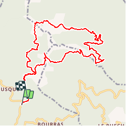
![](/images/other/stat-length.png)
![Tocht Stappen Saint-Roman-de-Codières - SAINT-ROMAN-DE-CODIERES - 12.6Km - 06h00 - Dénivelé 650 m - Photo](https://media.geolcdn.com/t/1900/400/ext.pjpeg?maxdim=2&url=https%3A%2F%2Fstatic1.geolcdn.com%2Fsiteimages%2Fupload%2Ffiles%2F1553511878bg_sport_marche.png)
SAINT-ROMAN-DE-CODIERES - 12.6Km - 06h00 - Dénivelé 650 m
dansmabulle
Gebruiker
![Lengte](/images/other/stat-length.png)
![Max. hoogte](https://static1.geolcdn.com/siteimages/upload/files/1508320355ic_sort_altitude_max_24dp.png)
![Positief hoogteverschil](https://static1.geolcdn.com/siteimages/upload/files/1508320355ic_sort_den_pos_24dp.png)
![Km-Effort](/images/other/stat-length.png)
![Min. hoogte](https://static1.geolcdn.com/siteimages/upload/files/1508320355ic_sort_altitude_min_24dp.png)
![Negatief hoogteverschil](https://static1.geolcdn.com/siteimages/upload/files/1508320355ic_sort_den_neg_24dp.png)
![Boucle](https://static1.geolcdn.com/siteimages/upload/files/16400158638029165_repeat_loop_refresh_sync_direction_icon.png)
![Stappen](https://static1.geolcdn.com/sitytour/trail-icons/101.png)
4h17
Moeilijkheid : Moeilijk
![Scan deze QR-code om de tocht te openen in de SityTrail-applicatie](https://capi.geolives.com/qq0zvz2zws4bq2lad0pu/sitytour/trails/245167/qr.png?size=200)
Gratisgps-wandelapplicatie
Over ons
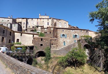
Tocht Stappen van 12,6 km beschikbaar op Occitanië, Gard, Saint-Roman-de-Codières. Deze tocht wordt voorgesteld door dansmabulle.
Beschrijving
Départ randonnée :
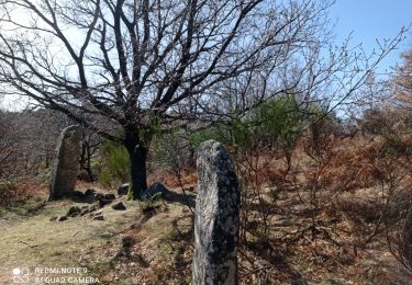
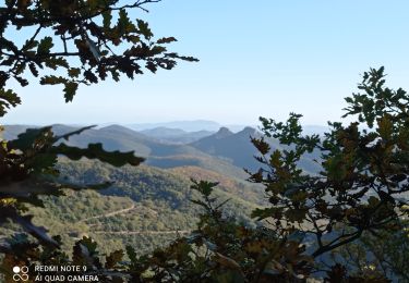
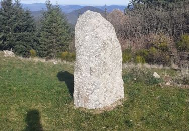
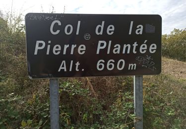
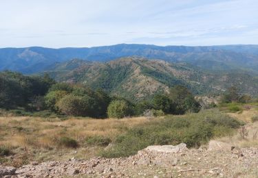
Col de la pierre Levée près de près de Saint-Roman-de-Codières ( gard 30) Se garer au col de la Pierre Levée. Faire 100m vers le Nord,à l'embranchement prendre le chemin du milieu.Le sentier démarre 200m plus loin à droite.Vous croiserez des chatainiers et vous aurez une belle vue sur l'Aigoual.200m après les menhirs, attention de ne pas manquer à droite le sentier peu marqué:il suit la combe, moitié sentier moitié ruisseau.En bas, prendre la piste. Plus loin, vue sur les Alpes et le Mont Ventoux.Au retour,on suit la piste ou on la quitte pour un sentier à gauche très peu marqué et dont les 100 derniers mètres avant de rejoindre le chemin de l'aller sont presque effacés.Bonne randonnée.
Plaatsbepaling
Opmerkingen
Wandeltochten in de omgeving
![Tocht Stappen Sumène - Le Ranc de Banes - Sumène - Photo](https://media.geolcdn.com/t/375/260/ext.jpg?maxdim=2&url=https%3A%2F%2Fservices.sitytrail.com%2FGeolivesWS%2FDownloadMedia.ashx%3FTrailID%3D106716%26Media%3D11360_5.jpg)
![Stappen Stappen](https://static1.geolcdn.com/sitytour/trail-icons/101.png)
Stappen
![](/images/other/stat-length.png)
![](https://static1.geolcdn.com/siteimages/upload/files/16400158638029165_repeat_loop_refresh_sync_direction_icon.png)
![Tocht Stappen La Cadière-et-Cambo - CAMBO - MONTAGNE DE LA FAGE - 7.6Km - 02h20 - Dénivelé 285 m - Photo](https://media.geolcdn.com/t/375/260/ext.jpg?maxdim=2&url=https%3A%2F%2Fstatic1.geolcdn.com%2Fsiteimages%2Fupload%2Ffiles%2F1553511878bg_sport_marche.png)
![Stappen Stappen](https://static1.geolcdn.com/sitytour/trail-icons/101.png)
Stappen
![](/images/other/stat-length.png)
![](https://static1.geolcdn.com/siteimages/upload/files/16400158638029165_repeat_loop_refresh_sync_direction_icon.png)
![Tocht Stappen Sumène - Sumene , le pont des chèvres - Photo](https://media.geolcdn.com/t/375/260/ed181aaa-ab94-42d0-bcb4-df9a435a052b.jpg&format=jpg&maxdim=2)
![Stappen Stappen](https://static1.geolcdn.com/sitytour/trail-icons/101.png)
Stappen
![](/images/other/stat-length.png)
![](https://static1.geolcdn.com/siteimages/upload/files/16400158638029165_repeat_loop_refresh_sync_direction_icon.png)
![Tocht Te voet Colognac - 30 du Cayrel au Camp Barrat 20/02/24 - Photo](https://media.geolcdn.com/t/375/260/db46be15-0ade-41ce-a4c3-6381b880347f.jpg&format=jpg&maxdim=2)
![Te voet Te voet](https://static1.geolcdn.com/sitytour/trail-icons/100.png)
Te voet
![](/images/other/stat-length.png)
![](https://static1.geolcdn.com/siteimages/upload/files/16400158638029165_repeat_loop_refresh_sync_direction_icon.png)
![Tocht Stappen Sumène - 30 les crêtes des cagnasses,a la fage 15/11/23 - Photo](https://media.geolcdn.com/t/375/260/327f6ae4-95a4-43dc-ae64-f238198e92ec.jpg&format=jpg&maxdim=2)
![Stappen Stappen](https://static1.geolcdn.com/sitytour/trail-icons/101.png)
Stappen
![](/images/other/stat-length.png)
![](https://static1.geolcdn.com/siteimages/upload/files/16400158638029165_repeat_loop_refresh_sync_direction_icon.png)
![Tocht Stappen Saint-Roman-de-Codières - st roman de codieres - Photo](https://media.geolcdn.com/t/375/260/20d79857-0660-4ad5-8bfa-f1464b2570fb.jpg&format=jpg&maxdim=2)
![Stappen Stappen](https://static1.geolcdn.com/sitytour/trail-icons/101.png)
Stappen
![](/images/other/stat-length.png)
![](https://static1.geolcdn.com/siteimages/upload/files/16400158638029165_repeat_loop_refresh_sync_direction_icon.png)
![Tocht Stappen Saint-Martial - Montagne du Liron au départ de St Martial - Photo](https://media.geolcdn.com/t/375/260/230ffbae-9a5c-40a3-841b-ca21b92f7b5b.jpg&format=jpg&maxdim=2)
![Stappen Stappen](https://static1.geolcdn.com/sitytour/trail-icons/101.png)
Stappen
![](/images/other/stat-length.png)
![](https://static1.geolcdn.com/siteimages/upload/files/16400158638029165_repeat_loop_refresh_sync_direction_icon.png)
![Tocht Stappen Saint-Roman-de-Codières - St Roman de Codiere 2 - Photo](https://media.geolcdn.com/t/375/260/eecdea35-1ea5-474d-b466-cf9b8758dea8.jpg&format=jpg&maxdim=2)
![Stappen Stappen](https://static1.geolcdn.com/sitytour/trail-icons/101.png)
Stappen
![](/images/other/stat-length.png)
![](https://static1.geolcdn.com/siteimages/upload/files/16400158638029165_repeat_loop_refresh_sync_direction_icon.png)
![Tocht Stappen Saint-Martial - arsel saint martial - Photo](https://media.geolcdn.com/t/375/260/7eb2b09d-8664-4214-8948-fa1b3d75088d.jpg&format=jpg&maxdim=2)
![Stappen Stappen](https://static1.geolcdn.com/sitytour/trail-icons/101.png)
Stappen
![](/images/other/stat-length.png)
![](https://static1.geolcdn.com/siteimages/upload/files/16400158638029165_repeat_loop_refresh_sync_direction_icon.png)