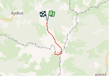
![](/images/other/stat-length.png)
![Tocht Stappen Aydius - Lac de Montagnon et pic Montagnon d'Iseye - Photo](https://media.geolcdn.com/t/1900/400/79e30076-f68a-4aa9-8c3c-46b60b0ada56.jpg&format=pjpeg&maxdim=2)
Lac de Montagnon et pic Montagnon d'Iseye
bedous
Gebruiker
![Lengte](/images/other/stat-length.png)
![Max. hoogte](https://static1.geolcdn.com/siteimages/upload/files/1508320355ic_sort_altitude_max_24dp.png)
![Positief hoogteverschil](https://static1.geolcdn.com/siteimages/upload/files/1508320355ic_sort_den_pos_24dp.png)
![Km-Effort](/images/other/stat-length.png)
![Min. hoogte](https://static1.geolcdn.com/siteimages/upload/files/1508320355ic_sort_altitude_min_24dp.png)
![Negatief hoogteverschil](https://static1.geolcdn.com/siteimages/upload/files/1508320355ic_sort_den_neg_24dp.png)
![Boucle](https://static1.geolcdn.com/siteimages/upload/files/16400158638029165_repeat_loop_refresh_sync_direction_icon.png)
![Stappen](https://static1.geolcdn.com/sitytour/trail-icons/101.png)
6h40
Moeilijkheid : Moeilijk
![Scan deze QR-code om de tocht te openen in de SityTrail-applicatie](https://capi.geolives.com/qq0zvz2zws4bq2lad0pu/sitytour/trails/2444823/qr.png?size=200)
Gratisgps-wandelapplicatie
Over ons
Tocht Stappen van 10,8 km beschikbaar op Nieuw-Aquitanië, Pyrénées-Atlantiques, Aydius. Deze tocht wordt voorgesteld door bedous.
Beschrijving
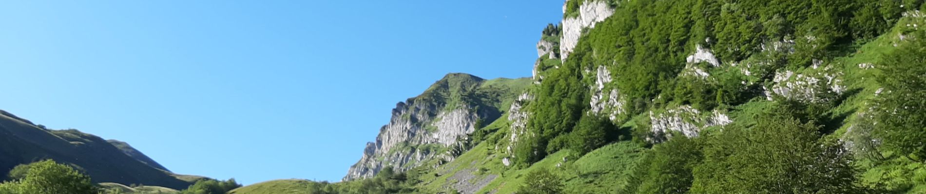
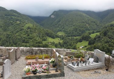
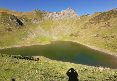
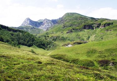
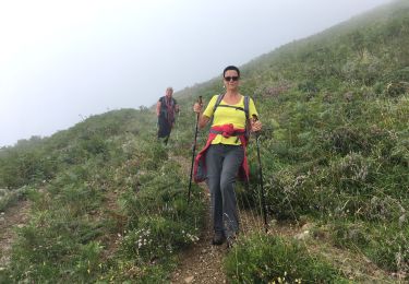
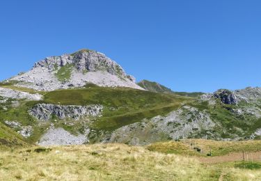
En vallée d'Aspe, du village d'Aydius suivre la piste d'accès ( très tôt le matin pour autorisation d'accès au plus près). La première heure de montée se déroule sous bois et est trés pentue ! Puis une longue rando qui monte au travers de paturages. L'accès au lac se termine par un sentier raide dans un pierré. Beaucoup d'effort pour un lieu magnifique. Un dernier effort pour atteindre le pic car vous aurez toujours envie d'y retourner pour les vues........
Plaatsbepaling
Opmerkingen
Wandeltochten in de omgeving
![Tocht Stappen Bielle - Pics de Cambeilh et petit Gerbe - Photo](https://media.geolcdn.com/t/375/260/ext.jpg?maxdim=2&url=https%3A%2F%2Fservices.sitytrail.com%2FGeolivesWS%2FDownloadMedia.ashx%3FTrailID%3D521181%26Media%3Dfix__20160202151847.jpg)
![Stappen Stappen](https://static1.geolcdn.com/sitytour/trail-icons/101.png)
Stappen
![](/images/other/stat-length.png)
![](https://static1.geolcdn.com/siteimages/upload/files/16400158638029165_repeat_loop_refresh_sync_direction_icon.png)
![Tocht Te voet Aydius - Tour du Mailh Massibé par Bésur asp100 - Photo](https://media.geolcdn.com/t/375/260/63a6bafa-5459-4dce-bf36-a3e4ba983890.jpeg&format=jpg&maxdim=2)
![Te voet Te voet](https://static1.geolcdn.com/sitytour/trail-icons/100.png)
Te voet
![](/images/other/stat-length.png)
![](https://static1.geolcdn.com/siteimages/upload/files/16400158638029165_repeat_loop_refresh_sync_direction_icon.png)
![Tocht Te voet Aydius - Chemin des Buis de Camploung asp22 - Photo](https://media.geolcdn.com/t/375/260/63a6bafa-5459-4dce-bf36-a3e4ba983890.jpeg&format=jpg&maxdim=2)
![Te voet Te voet](https://static1.geolcdn.com/sitytour/trail-icons/100.png)
Te voet
![](/images/other/stat-length.png)
![](https://static1.geolcdn.com/siteimages/upload/files/16400158638029165_repeat_loop_refresh_sync_direction_icon.png)
![Tocht Te voet Aydius - Col de Bergout par les Ichantes asp23 - Photo](https://media.geolcdn.com/t/375/260/63a6bafa-5459-4dce-bf36-a3e4ba983890.jpeg&format=jpg&maxdim=2)
![Te voet Te voet](https://static1.geolcdn.com/sitytour/trail-icons/100.png)
Te voet
![](/images/other/stat-length.png)
![](https://static1.geolcdn.com/siteimages/upload/files/16400158638029165_repeat_loop_refresh_sync_direction_icon.png)
![Tocht Stappen Aydius - lac de montagnon - Photo](https://media.geolcdn.com/t/375/260/5ed19e71-65a9-444b-82ea-9100b101a800.jpg&format=jpg&maxdim=2)
![Stappen Stappen](https://static1.geolcdn.com/sitytour/trail-icons/101.png)
Stappen
![](/images/other/stat-length.png)
![](https://static1.geolcdn.com/siteimages/upload/files/16400158638029165_repeat_loop_refresh_sync_direction_icon.png)
![Tocht Te voet Aydius - du Barca à la Cabane d'Arriutort asp106 - Photo](https://media.geolcdn.com/t/375/260/df582091-8896-406d-a764-75869922f6a5.jpeg&format=jpg&maxdim=2)
![Te voet Te voet](https://static1.geolcdn.com/sitytour/trail-icons/100.png)
Te voet
![](/images/other/stat-length.png)
![](https://static1.geolcdn.com/siteimages/upload/files/16400158638029165_repeat_loop_refresh_sync_direction_icon.png)
![Tocht Stappen Aydius - 021 Tour_Igaut-Chechit ab - Photo](https://media.geolcdn.com/t/375/260/4dff1440-f8d2-42a9-984d-2668c1d2f04d.jpg&format=jpg&maxdim=2)
![Stappen Stappen](https://static1.geolcdn.com/sitytour/trail-icons/101.png)
Stappen
![](/images/other/stat-length.png)
![](https://static1.geolcdn.com/siteimages/upload/files/16400158638029165_repeat_loop_refresh_sync_direction_icon.png)
![Tocht Stappen Accous - Cabane du Bergout - Photo](https://media.geolcdn.com/t/375/260/d517029d-cf6a-4526-aeb7-ac8002b292f1.jpg&format=jpg&maxdim=2)
![Stappen Stappen](https://static1.geolcdn.com/sitytour/trail-icons/101.png)
Stappen
![](/images/other/stat-length.png)
![](https://static1.geolcdn.com/siteimages/upload/files/16400158638029165_repeat_loop_refresh_sync_direction_icon.png)
![Tocht Stappen Aydius - pic mailh massibe et pic montagnon - Photo](https://media.geolcdn.com/t/375/260/12402e24-34c8-4e69-b3a6-ad60fc7c5ccb.jpg&format=jpg&maxdim=2)
![Stappen Stappen](https://static1.geolcdn.com/sitytour/trail-icons/101.png)
Stappen
![](/images/other/stat-length.png)
![](https://static1.geolcdn.com/siteimages/upload/files/16400158638029165_repeat_loop_refresh_sync_direction_icon.png)