![](/images/other/stat-length.png)
![Tocht Stappen Castillon-du-Gard - CASTILLON-DU-GARD 9.8Km - 02h20 - Dénivelé 140 m - Photo](https://media.geolcdn.com/t/1900/400/ext.pjpeg?maxdim=2&url=https%3A%2F%2Fstatic1.geolcdn.com%2Fsiteimages%2Fupload%2Ffiles%2F1553511878bg_sport_marche.png)
CASTILLON-DU-GARD 9.8Km - 02h20 - Dénivelé 140 m
dansmabulle
Gebruiker
![Lengte](/images/other/stat-length.png)
Lengte
9,8 km
![Max. hoogte](https://static1.geolcdn.com/siteimages/upload/files/1508320355ic_sort_altitude_max_24dp.png)
Max. hoogte
167 m
![Positief hoogteverschil](https://static1.geolcdn.com/siteimages/upload/files/1508320355ic_sort_den_pos_24dp.png)
Positief hoogteverschil
129 m
![Km-Effort](/images/other/stat-length.png)
Km-Effort
11,5 km
![Min. hoogte](https://static1.geolcdn.com/siteimages/upload/files/1508320355ic_sort_altitude_min_24dp.png)
Min. hoogte
56 m
![Negatief hoogteverschil](https://static1.geolcdn.com/siteimages/upload/files/1508320355ic_sort_den_neg_24dp.png)
Negatief hoogteverschil
129 m
![Boucle](https://static1.geolcdn.com/siteimages/upload/files/16400158638029165_repeat_loop_refresh_sync_direction_icon.png)
Boucle
Ja
Datum van aanmaak :
2014-12-10 00:00:00.0
Laatste wijziging :
2014-12-10 00:00:00.0
![Stappen](https://static1.geolcdn.com/sitytour/trail-icons/101.png)
2h33
Moeilijkheid : Medium
![Scan deze QR-code om de tocht te openen in de SityTrail-applicatie](https://capi.geolives.com/qq0zvz2zws4bq2lad0pu/sitytour/trails/244351/qr.png?size=200)
Gratisgps-wandelapplicatie
Over ons
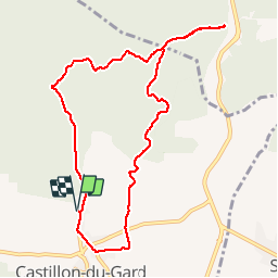
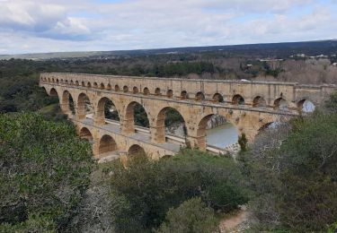
Tocht Stappen van 9,8 km beschikbaar op Occitanië, Gard, Castillon-du-Gard. Deze tocht wordt voorgesteld door dansmabulle.
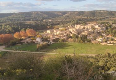
Beschrijving
CASTILLON-DU-GARD
9.8Km - 02:20
Départ randonnée : Lieux-dit Mas de Rafin à la sortie de Castillon-du-Gard (Gard 30) balade de 9,5 km dans la garrigue au nord de Castillon-du-Gard .Bonne randonnée.
Plaatsbepaling
Land:
France
Regio :
Occitanië
Departement/Provincie :
Gard
Gemeente :
Castillon-du-Gard
Locatie:
Unknown
Vertrek:(Dec)
Vertrek:(UTM)
624642 ; 4870557 (31T) N.
Opmerkingen
Wandeltochten in de omgeving
![Tocht Stappen Vers-Pont-du-Gard - Rando pont du Gard - Photo](https://media.geolcdn.com/t/375/260/ext.jpg?maxdim=2&url=https%3A%2F%2Fservices.sitytrail.com%2FGeolivesWS%2FDownloadMedia.ashx%3FTrailID%3D895180%26Media%3Dfix__20180128154606.jpg)
![Stappen Stappen](https://static1.geolcdn.com/sitytour/trail-icons/101.png)
Rando pont du Gard
Stappen
Gemakkelijk
(1)
Vers-Pont-du-Gard,
Occitanië,
Gard,
France
![](/images/other/stat-length.png)
6,8 km | 8,6 km-effort
2h 49min
![](https://static1.geolcdn.com/siteimages/upload/files/16400158638029165_repeat_loop_refresh_sync_direction_icon.png)
Neen
![Tocht Stappen Argilliers - Les Darbounelles - Argilliers - Photo](https://media.geolcdn.com/t/375/260/ext.jpg?maxdim=2&url=https%3A%2F%2Fservices.sitytrail.com%2FGeolivesWS%2FDownloadMedia.ashx%3FTrailID%3D214850%26Media%3D15388_6.jpg)
![Stappen Stappen](https://static1.geolcdn.com/sitytour/trail-icons/101.png)
Les Darbounelles - Argilliers
Stappen
Medium
(1)
Argilliers,
Occitanië,
Gard,
France
![](/images/other/stat-length.png)
11,4 km | 13,9 km-effort
3h 0min
![](https://static1.geolcdn.com/siteimages/upload/files/16400158638029165_repeat_loop_refresh_sync_direction_icon.png)
Ja
![Tocht Stappen Valliguières - Valliguières - St Pierre - Solidarité - Photo](https://media.geolcdn.com/t/375/260/34c7644f-964a-475b-8438-72b62b10d114.jpg&format=jpg&maxdim=2)
![Stappen Stappen](https://static1.geolcdn.com/sitytour/trail-icons/101.png)
Valliguières - St Pierre - Solidarité
Stappen
Medium
(1)
Valliguières,
Occitanië,
Gard,
France
![](/images/other/stat-length.png)
5,6 km | 7 km-effort
1h 35min
![](https://static1.geolcdn.com/siteimages/upload/files/16400158638029165_repeat_loop_refresh_sync_direction_icon.png)
Ja
![Tocht Stappen Valliguières - Valliguières - Etang - St Pierre - Photo](https://media.geolcdn.com/t/375/260/34c7644f-964a-475b-8438-72b62b10d114.jpg&format=jpg&maxdim=2)
![Stappen Stappen](https://static1.geolcdn.com/sitytour/trail-icons/101.png)
Valliguières - Etang - St Pierre
Stappen
Medium
(1)
Valliguières,
Occitanië,
Gard,
France
![](/images/other/stat-length.png)
7,3 km | 8,8 km-effort
2h 14min
![](https://static1.geolcdn.com/siteimages/upload/files/16400158638029165_repeat_loop_refresh_sync_direction_icon.png)
Ja
![Tocht Stappen Vers-Pont-du-Gard - Vers-pont-du-gard panorama-dfci - Photo](https://media.geolcdn.com/t/375/260/364a41da-e920-4623-9a68-e6731453cac6.jpg&format=jpg&maxdim=2)
![Stappen Stappen](https://static1.geolcdn.com/sitytour/trail-icons/101.png)
Vers-pont-du-gard panorama-dfci
Stappen
Medium
(2)
Vers-Pont-du-Gard,
Occitanië,
Gard,
France
![](/images/other/stat-length.png)
9,4 km | 11,5 km-effort
2h 31min
![](https://static1.geolcdn.com/siteimages/upload/files/16400158638029165_repeat_loop_refresh_sync_direction_icon.png)
Ja
![Tocht Stappen Saint-Hilaire-d'Ozilhan - SAINT-HILAIRE-D OZILHAN - FORET DE VALLONGUE - 11.7Km - 03h20 - Dénivelé 250 m - Photo](https://media.geolcdn.com/t/375/260/ext.jpg?maxdim=2&url=https%3A%2F%2Fstatic1.geolcdn.com%2Fsiteimages%2Fupload%2Ffiles%2F1553511878bg_sport_marche.png)
![Stappen Stappen](https://static1.geolcdn.com/sitytour/trail-icons/101.png)
SAINT-HILAIRE-D OZILHAN - FORET DE VALLONGUE - 11.7Km - 03h20 - Dénivelé 250 m
Stappen
Medium
(1)
Saint-Hilaire-d'Ozilhan,
Occitanië,
Gard,
France
![](/images/other/stat-length.png)
11,8 km | 14,7 km-effort
3h 14min
![](https://static1.geolcdn.com/siteimages/upload/files/16400158638029165_repeat_loop_refresh_sync_direction_icon.png)
Ja
![Tocht Stappen Vers-Pont-du-Gard - Vers-Pont-du-Guard - Photo](https://media.geolcdn.com/t/375/260/ext.jpg?maxdim=2&url=https%3A%2F%2Fstatic1.geolcdn.com%2Fsiteimages%2Fupload%2Ffiles%2F1553511878bg_sport_marche.png)
![Stappen Stappen](https://static1.geolcdn.com/sitytour/trail-icons/101.png)
Vers-Pont-du-Guard
Stappen
Gemakkelijk
(2)
Vers-Pont-du-Gard,
Occitanië,
Gard,
France
![](/images/other/stat-length.png)
8,7 km | 10,6 km-effort
2h 17min
![](https://static1.geolcdn.com/siteimages/upload/files/16400158638029165_repeat_loop_refresh_sync_direction_icon.png)
Ja
![Tocht Stappen Remoulins - remoulins by night - Photo](https://media.geolcdn.com/t/375/260/2d0bb882-ddf6-4872-bb3c-3db0a3975dfb.jpg&format=jpg&maxdim=2)
![Stappen Stappen](https://static1.geolcdn.com/sitytour/trail-icons/101.png)
remoulins by night
Stappen
Gemakkelijk
Remoulins,
Occitanië,
Gard,
France
![](/images/other/stat-length.png)
4,6 km | 5,2 km-effort
1h 35min
![](https://static1.geolcdn.com/siteimages/upload/files/16400158638029165_repeat_loop_refresh_sync_direction_icon.png)
Neen
![Tocht Stappen Vers-Pont-du-Gard - le-pont-du-gard-10km+175m.2024 - Photo](https://media.geolcdn.com/t/375/260/9ff5d1f9-99ef-47d9-8816-121bdee7a541.jpg&format=jpg&maxdim=2)
![Stappen Stappen](https://static1.geolcdn.com/sitytour/trail-icons/101.png)
le-pont-du-gard-10km+175m.2024
Stappen
Gemakkelijk
Vers-Pont-du-Gard,
Occitanië,
Gard,
France
![](/images/other/stat-length.png)
9,8 km | 12,1 km-effort
4h 26min
![](https://static1.geolcdn.com/siteimages/upload/files/16400158638029165_repeat_loop_refresh_sync_direction_icon.png)
Ja
Merci pour cette randonnée, mais si ce n'est la découverte du village de Castillon et d'avoir pris l'air, cette randonnée ne présente pas beaucoup d'intérêt...