![](/images/other/stat-length.png)
![Tocht Stappen Les Plans - Forêt domaniale d'Escandorgue par Roqueredonde et l'Engayresque - Photo](https://media.geolcdn.com/t/1900/400/c203cd03-9ac1-4e05-8a4c-6b4e6f9317be.jpg&format=pjpeg&maxdim=2)
Forêt domaniale d'Escandorgue par Roqueredonde et l'Engayresque
PiloudeBamako
Gebruiker
![Lengte](/images/other/stat-length.png)
![Max. hoogte](https://static1.geolcdn.com/siteimages/upload/files/1508320355ic_sort_altitude_max_24dp.png)
![Positief hoogteverschil](https://static1.geolcdn.com/siteimages/upload/files/1508320355ic_sort_den_pos_24dp.png)
![Km-Effort](/images/other/stat-length.png)
![Min. hoogte](https://static1.geolcdn.com/siteimages/upload/files/1508320355ic_sort_altitude_min_24dp.png)
![Negatief hoogteverschil](https://static1.geolcdn.com/siteimages/upload/files/1508320355ic_sort_den_neg_24dp.png)
![Boucle](https://static1.geolcdn.com/siteimages/upload/files/16400158638029165_repeat_loop_refresh_sync_direction_icon.png)
![Stappen](https://static1.geolcdn.com/sitytour/trail-icons/101.png)
5h02
Moeilijkheid : Medium
![Scan deze QR-code om de tocht te openen in de SityTrail-applicatie](https://capi.geolives.com/qq0zvz2zws4bq2lad0pu/sitytour/trails/2440913/qr.png?size=200)
Gratisgps-wandelapplicatie
Over ons
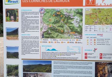
Tocht Stappen van 14,2 km beschikbaar op Occitanië, Hérault, Les Plans. Deze tocht wordt voorgesteld door PiloudeBamako.
Beschrijving
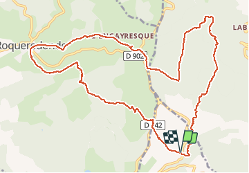
Départ sur la D902 reliant Lodève à Roqueredonde, à proximité du radar météorologique (voir le point d'intérêt) situé sur la commune de "Les Plans" (à l'intersection entre la D902 et le GR71).
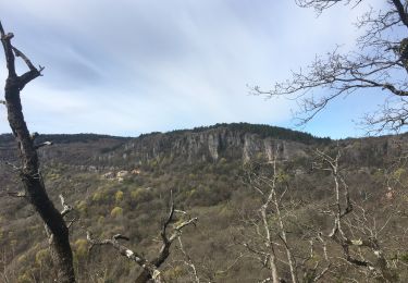
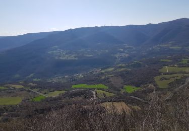
Suivre le GR 71 vers Roqueredonde par le Mas de Grèzes, puis direction l'Engayresque et son Temple bouddhiste Lerab Ling.
Retour en traversant de la forêt domaniale de l'Escandorgue en direction de Labeil.
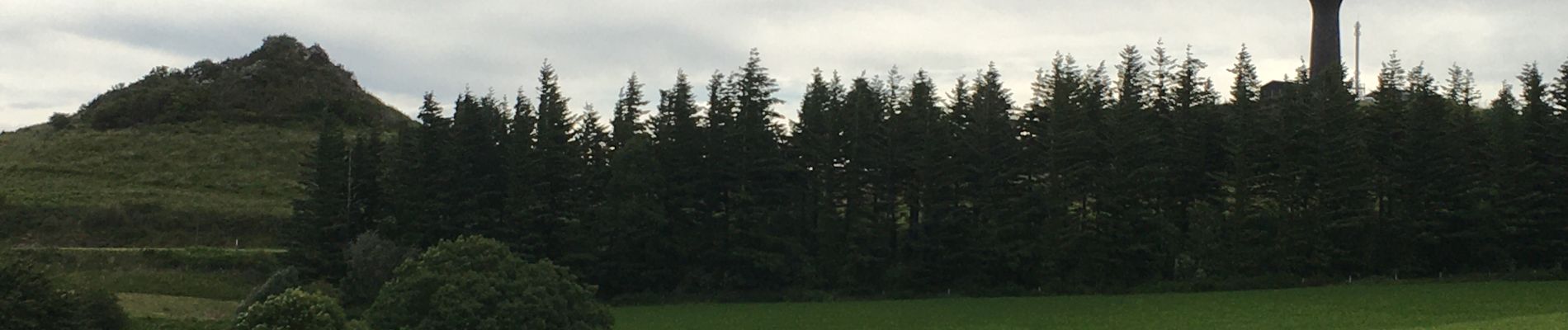
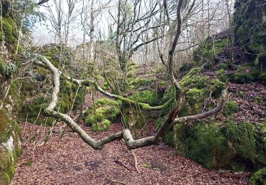
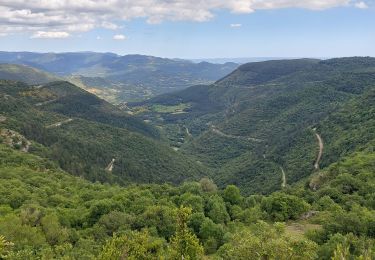
Plaatsbepaling
Opmerkingen
Wandeltochten in de omgeving
![Tocht Noords wandelen Joncels - RANDONNÉE JONCELS CIRCUIT ARCHÉOLOGIQUE - Photo](https://media.geolcdn.com/t/375/260/0eb6a312-d62e-40e4-973b-25f789da995e.png&format=jpg&maxdim=2)
![Noords wandelen Noords wandelen](https://static1.geolcdn.com/sitytour/trail-icons/102.png)
Noords wandelen
![](/images/other/stat-length.png)
![](https://static1.geolcdn.com/siteimages/upload/files/16400158638029165_repeat_loop_refresh_sync_direction_icon.png)
![Tocht Noords wandelen Lauroux - SityTrail - Labeil Forêt de l'Escandorgue Juin 2021 - Photo](https://media.geolcdn.com/t/375/260/c2282928-f752-4149-927b-0f9ea4e169ca.jpg&format=jpg&maxdim=2)
![Noords wandelen Noords wandelen](https://static1.geolcdn.com/sitytour/trail-icons/102.png)
Noords wandelen
![](/images/other/stat-length.png)
![](https://static1.geolcdn.com/siteimages/upload/files/16400158638029165_repeat_loop_refresh_sync_direction_icon.png)
![Tocht Stappen Lauroux - les corniches de lauroux - Photo](https://media.geolcdn.com/t/375/260/ext.jpg?maxdim=2&url=https%3A%2F%2Fservices.sitytrail.com%2FGeolivesWS%2FDownloadMedia.ashx%3FTrailID%3D333456%26Media%3D20140811173610.jpg)
![Stappen Stappen](https://static1.geolcdn.com/sitytour/trail-icons/101.png)
Stappen
![](/images/other/stat-length.png)
![](https://static1.geolcdn.com/siteimages/upload/files/16400158638029165_repeat_loop_refresh_sync_direction_icon.png)
![Tocht Stappen Lauroux - cirque de labeil - Photo](https://media.geolcdn.com/t/375/260/ext.jpg?maxdim=2&url=https%3A%2F%2Fservices.sitytrail.com%2FGeolivesWS%2FDownloadMedia.ashx%3FTrailID%3D199890%26Media%3D20130622153523.jpg)
![Stappen Stappen](https://static1.geolcdn.com/sitytour/trail-icons/101.png)
Stappen
![](/images/other/stat-length.png)
![](https://static1.geolcdn.com/siteimages/upload/files/16400158638029165_repeat_loop_refresh_sync_direction_icon.png)
![Tocht Stappen Les Plans - La boucle des boutisses - Photo](https://media.geolcdn.com/t/375/260/c6f71489-8e25-42eb-bfcc-c19f3e3099d6.jpg&format=jpg&maxdim=2)
![Stappen Stappen](https://static1.geolcdn.com/sitytour/trail-icons/101.png)
Stappen
![](/images/other/stat-length.png)
![](https://static1.geolcdn.com/siteimages/upload/files/16400158638029165_repeat_loop_refresh_sync_direction_icon.png)
![Tocht Stappen Les Plans - Forêt et cirque de Labeil - Photo](https://media.geolcdn.com/t/375/260/21b3d7b0-35ee-491f-98e6-53e535349997.jpg&format=jpg&maxdim=2)
![Stappen Stappen](https://static1.geolcdn.com/sitytour/trail-icons/101.png)
Stappen
![](/images/other/stat-length.png)
![](https://static1.geolcdn.com/siteimages/upload/files/16400158638029165_repeat_loop_refresh_sync_direction_icon.png)
![Tocht Stappen Lauroux - Cirque de Labeil - Lauroux-Labeil - Photo](https://media.geolcdn.com/t/375/260/8fdc9c8b-a7e7-4b91-a76e-1064fb68239e.jpg&format=jpg&maxdim=2)
![Stappen Stappen](https://static1.geolcdn.com/sitytour/trail-icons/101.png)
Stappen
![](/images/other/stat-length.png)
![](https://static1.geolcdn.com/siteimages/upload/files/16400158638029165_repeat_loop_refresh_sync_direction_icon.png)
![Tocht Stappen Lauroux - les corniches de Lauroux - Photo](https://media.geolcdn.com/t/375/260/30247f3d-9089-4d90-9b6f-cf266f5c907e.jpg&format=jpg&maxdim=2)
![Stappen Stappen](https://static1.geolcdn.com/sitytour/trail-icons/101.png)
Stappen
![](/images/other/stat-length.png)
![](https://static1.geolcdn.com/siteimages/upload/files/16400158638029165_repeat_loop_refresh_sync_direction_icon.png)
![Noords wandelen Noords wandelen](https://static1.geolcdn.com/sitytour/trail-icons/102.png)
Noords wandelen
![](/images/other/stat-length.png)
![](https://static1.geolcdn.com/siteimages/upload/files/16400158638029165_repeat_loop_refresh_sync_direction_icon.png)
Superbe rando du début à la fin Nombreux passages ombragés À faire sans hésitation