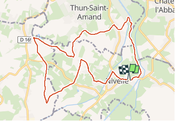
![](/images/other/stat-length.png)
![Tocht Stappen Nivelle - le tour de Nivelle par Thun et écluses de Mortagne - Photo](https://media.geolcdn.com/t/1900/400/78d714c8-4477-468a-912e-b11f83b436bd.jpg&format=pjpeg&maxdim=2)
le tour de Nivelle par Thun et écluses de Mortagne
papiou
Gebruiker
![Lengte](/images/other/stat-length.png)
![Max. hoogte](https://static1.geolcdn.com/siteimages/upload/files/1508320355ic_sort_altitude_max_24dp.png)
![Positief hoogteverschil](https://static1.geolcdn.com/siteimages/upload/files/1508320355ic_sort_den_pos_24dp.png)
![Km-Effort](/images/other/stat-length.png)
![Min. hoogte](https://static1.geolcdn.com/siteimages/upload/files/1508320355ic_sort_altitude_min_24dp.png)
![Negatief hoogteverschil](https://static1.geolcdn.com/siteimages/upload/files/1508320355ic_sort_den_neg_24dp.png)
![Boucle](https://static1.geolcdn.com/siteimages/upload/files/16400158638029165_repeat_loop_refresh_sync_direction_icon.png)
![Stappen](https://static1.geolcdn.com/sitytour/trail-icons/101.png)
2h00
Moeilijkheid : Gemakkelijk
![Scan deze QR-code om de tocht te openen in de SityTrail-applicatie](https://capi.geolives.com/qq0zvz2zws4bq2lad0pu/sitytour/trails/2435686/qr.png?size=200)
Gratisgps-wandelapplicatie
Over ons
Tocht Stappen van 10,5 km beschikbaar op Hauts-de-France, Noorderdepartement, Nivelle. Deze tocht wordt voorgesteld door papiou.
Beschrijving
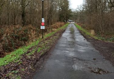
rdv hall de Nivelle près du pont de la Scarpe. en sortant du parking prendre à gauche puis passer à droite du calvaire et rejoindre le CD, prendre à gauche puis à droite et suivre le circuit sur l'appli en passant par église de Thun et écluses de Mortagne et retour par berge de la Scarpe et le pont.
Plaatsbepaling
Opmerkingen
Wandeltochten in de omgeving
![Tocht Stappen Hergnies - Entre terre et eaux - Hergnies - Photo](https://media.geolcdn.com/t/375/260/ext.jpg?maxdim=2&url=https%3A%2F%2Fservices.sitytrail.com%2FGeolivesWS%2FDownloadMedia.ashx%3FTrailID%3D111915%26Media%3D8943_6.jpg)
![Stappen Stappen](https://static1.geolcdn.com/sitytour/trail-icons/101.png)
Stappen
![](/images/other/stat-length.png)
![](https://static1.geolcdn.com/siteimages/upload/files/16400158638029165_repeat_loop_refresh_sync_direction_icon.png)
![Tocht Stappen Mortagne-du-Nord - Mortagne-du-Nord 18,6 km - Photo](https://media.geolcdn.com/t/375/260/fd97f041-03e8-458c-b32d-9e5c0c535a41.jpg&format=jpg&maxdim=2)
![Stappen Stappen](https://static1.geolcdn.com/sitytour/trail-icons/101.png)
Stappen
![](/images/other/stat-length.png)
![](https://static1.geolcdn.com/siteimages/upload/files/16400158638029165_repeat_loop_refresh_sync_direction_icon.png)
![Tocht Stappen Saint-Amand-les-Eaux - terril vicoigne - Photo](https://media.geolcdn.com/t/375/260/d8552856-5959-4bc8-a6d2-93f721ca17ec.jpg&format=jpg&maxdim=2)
![Stappen Stappen](https://static1.geolcdn.com/sitytour/trail-icons/101.png)
Stappen
![](/images/other/stat-length.png)
![](https://static1.geolcdn.com/siteimages/upload/files/16400158638029165_repeat_loop_refresh_sync_direction_icon.png)
![Tocht Stappen Flines-lès-Mortagne - De Flines les Mortane à Bernissart (Belgique) - Photo](https://media.geolcdn.com/t/375/260/ca739f87-71b6-494f-8d4f-d2141a94b6cf.jpg&format=jpg&maxdim=2)
![Stappen Stappen](https://static1.geolcdn.com/sitytour/trail-icons/101.png)
Stappen
![](/images/other/stat-length.png)
![](https://static1.geolcdn.com/siteimages/upload/files/16400158638029165_repeat_loop_refresh_sync_direction_icon.png)
![Tocht Stappen Saint-Amand-les-Eaux - notre dame d'amour(NDA), propose par VDN - Photo](https://media.geolcdn.com/t/375/260/630cd120-0ef0-4a83-86e7-91e6331d9f35.jpg&format=jpg&maxdim=2)
![Stappen Stappen](https://static1.geolcdn.com/sitytour/trail-icons/101.png)
Stappen
![](/images/other/stat-length.png)
![](https://static1.geolcdn.com/siteimages/upload/files/16400158638029165_repeat_loop_refresh_sync_direction_icon.png)
![Tocht Stappen Nivelle - Nivelle- circuit Nivelle-Mortagne-Chateau l'abbaye - Photo](https://media.geolcdn.com/t/375/260/d91e613a-8448-41fc-bfd3-8fd05bd73b48.jpg&format=jpg&maxdim=2)
![Stappen Stappen](https://static1.geolcdn.com/sitytour/trail-icons/101.png)
Stappen
![](/images/other/stat-length.png)
![](https://static1.geolcdn.com/siteimages/upload/files/16400158638029165_repeat_loop_refresh_sync_direction_icon.png)
![Tocht Stappen Château-l'Abbaye - château l'abbaye. entre Escaut et Scarpe - Photo](https://media.geolcdn.com/t/375/260/21c122b9-cbf8-4e60-94a2-4e2f3c16b33a.jpg&format=jpg&maxdim=2)
![Stappen Stappen](https://static1.geolcdn.com/sitytour/trail-icons/101.png)
Stappen
![](/images/other/stat-length.png)
![](https://static1.geolcdn.com/siteimages/upload/files/16400158638029165_repeat_loop_refresh_sync_direction_icon.png)
![Tocht Stappen Saint-Amand-les-Eaux - Mesnil, version plus longue - Photo](https://media.geolcdn.com/t/375/260/e5ac201c-8480-46b8-81d2-a49e027ccf3b.jpg&format=jpg&maxdim=2)
![Stappen Stappen](https://static1.geolcdn.com/sitytour/trail-icons/101.png)
Stappen
![](/images/other/stat-length.png)
![](https://static1.geolcdn.com/siteimages/upload/files/16400158638029165_repeat_loop_refresh_sync_direction_icon.png)
![Tocht Stappen Saint-Amand-les-Eaux - Mesnil. st Amand - Photo](https://media.geolcdn.com/t/375/260/8721f904-61d7-45b4-8ccf-882922ad0ed2.jpg&format=jpg&maxdim=2)
![Stappen Stappen](https://static1.geolcdn.com/sitytour/trail-icons/101.png)
Stappen
![](/images/other/stat-length.png)
![](https://static1.geolcdn.com/siteimages/upload/files/16400158638029165_repeat_loop_refresh_sync_direction_icon.png)