![](/images/other/stat-length.png)
![Tocht Stappen Laguiole - Le Roc des Cabres - Photo](https://media.geolcdn.com/t/1900/400/ext.pjpeg?maxdim=2&url=https%3A%2F%2Fstatic1.geolcdn.com%2Fsiteimages%2Fupload%2Ffiles%2F1553511878bg_sport_marche.png)
Le Roc des Cabres
Tournan
Gebruiker
![Lengte](/images/other/stat-length.png)
Lengte
12,5 km
![Max. hoogte](https://static1.geolcdn.com/siteimages/upload/files/1508320355ic_sort_altitude_max_24dp.png)
Max. hoogte
1136 m
![Positief hoogteverschil](https://static1.geolcdn.com/siteimages/upload/files/1508320355ic_sort_den_pos_24dp.png)
Positief hoogteverschil
310 m
![Km-Effort](/images/other/stat-length.png)
Km-Effort
16,6 km
![Min. hoogte](https://static1.geolcdn.com/siteimages/upload/files/1508320355ic_sort_altitude_min_24dp.png)
Min. hoogte
940 m
![Negatief hoogteverschil](https://static1.geolcdn.com/siteimages/upload/files/1508320355ic_sort_den_neg_24dp.png)
Negatief hoogteverschil
310 m
![Boucle](https://static1.geolcdn.com/siteimages/upload/files/16400158638029165_repeat_loop_refresh_sync_direction_icon.png)
Boucle
Ja
Datum van aanmaak :
2020-06-05 15:45:12.584
Laatste wijziging :
2020-06-05 15:57:11.875
![Stappen](https://static1.geolcdn.com/sitytour/trail-icons/101.png)
3h32
Moeilijkheid : Moeilijk
![Scan deze QR-code om de tocht te openen in de SityTrail-applicatie](https://capi.geolives.com/qq0zvz2zws4bq2lad0pu/sitytour/trails/2425473/qr.png?size=200)
Gratisgps-wandelapplicatie
Over ons
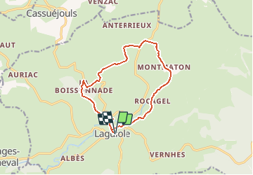
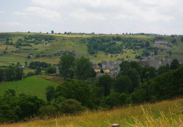
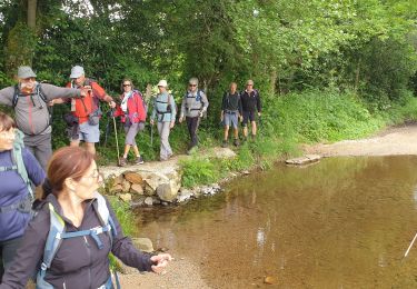
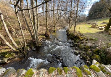
Tocht Stappen van 12,5 km beschikbaar op Occitanië, Aveyron, Laguiole. Deze tocht wordt voorgesteld door Tournan.
Beschrijving
Situation : Sur la D 921 à partir d’Espalion et de Saint Flour et depuis la D 920 suivie de la D 42 à partir d’Aurillac. Parking : Place du Foirail (Taureau) à Laguiole Balisage : De 1 à 2 jaune/rouge et De 2 à 7 jaune
Plaatsbepaling
Land:
France
Regio :
Occitanië
Departement/Provincie :
Aveyron
Gemeente :
Laguiole
Locatie:
Unknown
Vertrek:(Dec)
Vertrek:(UTM)
487985 ; 4947826 (31T) N.
Opmerkingen
Wandeltochten in de omgeving
![Tocht Fiets Laguiole - Les courbes infinies de l'Aubrac - Laguiole - Photo](https://media.geolcdn.com/t/375/260/ext.jpg?maxdim=2&url=https%3A%2F%2Fservices.sitytrail.com%2FGeolivesWS%2FDownloadMedia.ashx%3FTrailID%3D129656%26Media%3D13184_5.jpg)
![Fiets Fiets](https://static1.geolcdn.com/sitytour/trail-icons/200.png)
Les courbes infinies de l'Aubrac - Laguiole
Fiets
Moeilijk
(1)
Laguiole,
Occitanië,
Aveyron,
France
![](/images/other/stat-length.png)
75 km | 90 km-effort
5h 0min
![](https://static1.geolcdn.com/siteimages/upload/files/16400158638029165_repeat_loop_refresh_sync_direction_icon.png)
Ja
![Tocht sport Soulages-Bonneval - 2024-06-12_14h41m44_visorando-circuit-autour-du-lac-des-galens - Photo](https://media.geolcdn.com/t/375/260/ext.jpg?maxdim=2&url=https%3A%2F%2Fsecurestorage.geolives.com%2Fsitytour%2Ftrail-bg%2Fdefault.jpg)
2024-06-12_14h41m44_visorando-circuit-autour-du-lac-des-galens
sport
Heel gemakkelijk
(2)
Soulages-Bonneval,
Occitanië,
Aveyron,
France
![](/images/other/stat-length.png)
11,4 km | 14,3 km-effort
Onbekend
![](https://static1.geolcdn.com/siteimages/upload/files/16400158638029165_repeat_loop_refresh_sync_direction_icon.png)
Ja
![Tocht Stappen Curières - hier - Photo](https://media.geolcdn.com/t/375/260/9490aa44-9d58-4d6b-baaf-b8514dbcec92.jpg&format=jpg&maxdim=2)
![Stappen Stappen](https://static1.geolcdn.com/sitytour/trail-icons/101.png)
![Tocht Stappen Laguiole - Soulagese Chateau du ousquet - Photo](https://media.geolcdn.com/t/375/260/ed6186cd-dbcb-4b9f-86d8-0190cd90d208.jpg&format=jpg&maxdim=2)
![Stappen Stappen](https://static1.geolcdn.com/sitytour/trail-icons/101.png)
Soulagese Chateau du ousquet
Stappen
Gemakkelijk
Laguiole,
Occitanië,
Aveyron,
France
![](/images/other/stat-length.png)
15,2 km | 19,8 km-effort
5h 48min
![](https://static1.geolcdn.com/siteimages/upload/files/16400158638029165_repeat_loop_refresh_sync_direction_icon.png)
Ja
![Tocht Stappen Laguiole - Laguiole Roc Del Cabres - Photo](https://media.geolcdn.com/t/375/260/572d7cbc-7f57-4674-9842-dac40b488b56.jpg&format=jpg&maxdim=2)
![Stappen Stappen](https://static1.geolcdn.com/sitytour/trail-icons/101.png)
Laguiole Roc Del Cabres
Stappen
Gemakkelijk
Laguiole,
Occitanië,
Aveyron,
France
![](/images/other/stat-length.png)
12,3 km | 16,3 km-effort
3h 3min
![](https://static1.geolcdn.com/siteimages/upload/files/16400158638029165_repeat_loop_refresh_sync_direction_icon.png)
Ja
![Tocht Stappen Cassuéjouls - Cassuejouls 24 02 06 - Photo](https://media.geolcdn.com/t/375/260/25c7b790-2720-4c14-af65-90a96a4717b3.jpg&format=jpg&maxdim=2)
![Stappen Stappen](https://static1.geolcdn.com/sitytour/trail-icons/101.png)
Cassuejouls 24 02 06
Stappen
Heel gemakkelijk
Cassuéjouls,
Occitanië,
Aveyron,
France
![](/images/other/stat-length.png)
8,8 km | 12,1 km-effort
2h 17min
![](https://static1.geolcdn.com/siteimages/upload/files/16400158638029165_repeat_loop_refresh_sync_direction_icon.png)
Ja
![Tocht Stappen Laguiole - Laguiole Pigasse - Photo](https://media.geolcdn.com/t/375/260/a4af4d41-c2d4-4b57-b319-c0c46e5ff3e0.jpg&format=jpg&maxdim=2)
![Stappen Stappen](https://static1.geolcdn.com/sitytour/trail-icons/101.png)
Laguiole Pigasse
Stappen
Gemakkelijk
Laguiole,
Occitanië,
Aveyron,
France
![](/images/other/stat-length.png)
6,2 km | 8,4 km-effort
1h 47min
![](https://static1.geolcdn.com/siteimages/upload/files/16400158638029165_repeat_loop_refresh_sync_direction_icon.png)
Ja
![Tocht Stappen Laguiole - le roc des cabres - Photo](https://media.geolcdn.com/t/375/260/911a3d0d-fb87-43a8-ad59-9a05146d2b97.jpg&format=jpg&maxdim=2)
![Stappen Stappen](https://static1.geolcdn.com/sitytour/trail-icons/101.png)
le roc des cabres
Stappen
Gemakkelijk
Laguiole,
Occitanië,
Aveyron,
France
![](/images/other/stat-length.png)
13,7 km | 18,1 km-effort
4h 16min
![](https://static1.geolcdn.com/siteimages/upload/files/16400158638029165_repeat_loop_refresh_sync_direction_icon.png)
Ja
![Tocht Stappen Curières - la croix du Pal - Photo](https://media.geolcdn.com/t/375/260/b0f549f4-0aab-46a5-8cb4-8000321838be.jpg&format=jpg&maxdim=2)
![Stappen Stappen](https://static1.geolcdn.com/sitytour/trail-icons/101.png)
la croix du Pal
Stappen
Medium
Curières,
Occitanië,
Aveyron,
France
![](/images/other/stat-length.png)
15,2 km | 22 km-effort
4h 29min
![](https://static1.geolcdn.com/siteimages/upload/files/16400158638029165_repeat_loop_refresh_sync_direction_icon.png)
Ja