![](/images/other/stat-length.png)
![Tocht Te voet Thollon-les-Mémises - Le Grand Roc et retour - Photo](https://media.geolcdn.com/t/1900/400/ext.pjpeg?maxdim=2&url=https%3A%2F%2Fstatic1.geolcdn.com%2Fsiteimages%2Fupload%2Ffiles%2F1545311037marcheuse_200dpi.jpg)
Le Grand Roc et retour
otbernex
Gebruiker
![Lengte](/images/other/stat-length.png)
![Max. hoogte](https://static1.geolcdn.com/siteimages/upload/files/1508320355ic_sort_altitude_max_24dp.png)
![Positief hoogteverschil](https://static1.geolcdn.com/siteimages/upload/files/1508320355ic_sort_den_pos_24dp.png)
![Km-Effort](/images/other/stat-length.png)
![Min. hoogte](https://static1.geolcdn.com/siteimages/upload/files/1508320355ic_sort_altitude_min_24dp.png)
![Negatief hoogteverschil](https://static1.geolcdn.com/siteimages/upload/files/1508320355ic_sort_den_neg_24dp.png)
![Boucle](https://static1.geolcdn.com/siteimages/upload/files/16400158638029165_repeat_loop_refresh_sync_direction_icon.png)
![Te voet](https://static1.geolcdn.com/sitytour/trail-icons/100.png)
1h10
Moeilijkheid : Heel gemakkelijk
![Scan deze QR-code om de tocht te openen in de SityTrail-applicatie](https://capi.geolives.com/qq0zvz2zws4bq2lad0pu/sitytour/trails/2424882/qr.png?size=200)
Gratisgps-wandelapplicatie
Over ons
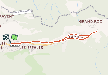
Tocht Te voet van 4 km beschikbaar op Auvergne-Rhône-Alpes, Haute-Savoie, Thollon-les-Mémises. Deze tocht wordt voorgesteld door otbernex.
Beschrijving
Depuis Thollon Tourisme, suivre les
indications pour Lajoux en longeant la
route goudronnée. Avant le restaurant
l’Outa, prendre à gauche le chemin
piéton puis vous passerez devant la
grotte de Notre Dame des Auguets.
Prendre sur la droite le chemin de
Croix. Vous arrivez à l’entrée du
hameau de Lajoux et suivre la route
goudronnée Le Grand Roc. Dans le
virage, superbe belvédère sur le haut
lac. Vue sur l’embouchure du Rhône,
les Alpes Vaudoises et Valaisannes.
Vous avez en face de vous le coeur des
Alpes Suisses. Retour par le même chemin.
Plaatsbepaling
Opmerkingen
Wandeltochten in de omgeving
![Tocht Stappen Bernex - Dent d'Oche - coucher de soleil - Photo](https://media.geolcdn.com/t/375/260/ext.jpg?maxdim=2&url=https%3A%2F%2Fservices.sitytrail.com%2FGeolivesWS%2FDownloadMedia.ashx%3FTrailID%3D310307%26Media%3Dfix__20140607223141.jpg)
![Stappen Stappen](https://static1.geolcdn.com/sitytour/trail-icons/101.png)
Stappen
![](/images/other/stat-length.png)
![](https://static1.geolcdn.com/siteimages/upload/files/16400158638029165_repeat_loop_refresh_sync_direction_icon.png)
![Tocht Stappen Bernex - Pic des mémises . colombier par Creusaz - Photo](https://media.geolcdn.com/t/375/260/ext.jpg?maxdim=2&url=https%3A%2F%2Fservices.sitytrail.com%2FGeolivesWS%2FDownloadMedia.ashx%3FTrailID%3D491351%26Media%3Dfix__20151108110454.jpg)
![Stappen Stappen](https://static1.geolcdn.com/sitytour/trail-icons/101.png)
Stappen
![](/images/other/stat-length.png)
![](https://static1.geolcdn.com/siteimages/upload/files/16400158638029165_repeat_loop_refresh_sync_direction_icon.png)
![Tocht Stappen Bernex - Rando Bernex - Photo](https://media.geolcdn.com/t/375/260/28985832-c41d-4d1f-9a6e-3334337a9656.jpg&format=jpg&maxdim=2)
![Stappen Stappen](https://static1.geolcdn.com/sitytour/trail-icons/101.png)
Stappen
![](/images/other/stat-length.png)
![](https://static1.geolcdn.com/siteimages/upload/files/16400158638029165_repeat_loop_refresh_sync_direction_icon.png)
![Tocht Stappen Bernex - DENT D'OCHE ET LAC D'ARBON - Photo](https://media.geolcdn.com/t/375/260/9f9c1e84-a408-45e1-b0fa-60f5ada5bf93.jpg&format=jpg&maxdim=2)
![Stappen Stappen](https://static1.geolcdn.com/sitytour/trail-icons/101.png)
Stappen
![](/images/other/stat-length.png)
![](https://static1.geolcdn.com/siteimages/upload/files/16400158638029165_repeat_loop_refresh_sync_direction_icon.png)
![Tocht Stappen Bernex - Boucle depuis Pre Richard.. - Photo](https://media.geolcdn.com/t/375/260/c7de377d-1993-4d05-b6af-1aa619f7194a.jpg&format=jpg&maxdim=2)
![Stappen Stappen](https://static1.geolcdn.com/sitytour/trail-icons/101.png)
Stappen
![](/images/other/stat-length.png)
![](https://static1.geolcdn.com/siteimages/upload/files/16400158638029165_repeat_loop_refresh_sync_direction_icon.png)
![Tocht Stappen Thollon-les-Mémises - Pic des Mémises-Col de Pertuis-Le Hameau de L’Ain retour Parking - Photo](https://media.geolcdn.com/t/375/260/467816a0-c474-459e-8ee3-3c2a806c5171.jpg&format=jpg&maxdim=2)
![Stappen Stappen](https://static1.geolcdn.com/sitytour/trail-icons/101.png)
Stappen
![](/images/other/stat-length.png)
![](https://static1.geolcdn.com/siteimages/upload/files/16400158638029165_repeat_loop_refresh_sync_direction_icon.png)
![Tocht Stappen Bernex - Tour du Mont César - Photo](https://media.geolcdn.com/t/375/260/2fcb6365-f8f6-412f-a611-4f5e9f93d038.jpg&format=jpg&maxdim=2)
![Stappen Stappen](https://static1.geolcdn.com/sitytour/trail-icons/101.png)
Stappen
![](/images/other/stat-length.png)
![](https://static1.geolcdn.com/siteimages/upload/files/16400158638029165_repeat_loop_refresh_sync_direction_icon.png)
![Tocht Noords wandelen Bernex - DENT D OCHE PAR PIC BOLLE - Photo](https://media.geolcdn.com/t/375/260/3b15ca9c-313e-4058-bef3-f6ae0d842713.jpg&format=jpg&maxdim=2)
![Noords wandelen Noords wandelen](https://static1.geolcdn.com/sitytour/trail-icons/102.png)
Noords wandelen
![](/images/other/stat-length.png)
![](https://static1.geolcdn.com/siteimages/upload/files/16400158638029165_repeat_loop_refresh_sync_direction_icon.png)
![Tocht Stappen Saint-Paul-en-Chablais - lac noir grand tour - Photo](https://media.geolcdn.com/t/375/260/ext.jpg?maxdim=2&url=https%3A%2F%2Fstatic1.geolcdn.com%2Fsiteimages%2Fupload%2Ffiles%2F1553511878bg_sport_marche.png)
![Stappen Stappen](https://static1.geolcdn.com/sitytour/trail-icons/101.png)
Stappen
![](/images/other/stat-length.png)
![](https://static1.geolcdn.com/siteimages/upload/files/16400158638029165_repeat_loop_refresh_sync_direction_icon.png)