![](/images/other/stat-length.png)
![Tocht Stappen Montigny - Autour de Montigny - Photo](https://media.geolcdn.com/t/1900/400/ext.pjpeg?maxdim=2&url=https%3A%2F%2Fstatic1.geolcdn.com%2Fsiteimages%2Fupload%2Ffiles%2F1553511878bg_sport_marche.png)
Autour de Montigny
JMCMoreau
Gebruiker
![Lengte](/images/other/stat-length.png)
Lengte
11,1 km
![Max. hoogte](https://static1.geolcdn.com/siteimages/upload/files/1508320355ic_sort_altitude_max_24dp.png)
Max. hoogte
147 m
![Positief hoogteverschil](https://static1.geolcdn.com/siteimages/upload/files/1508320355ic_sort_den_pos_24dp.png)
Positief hoogteverschil
176 m
![Km-Effort](/images/other/stat-length.png)
Km-Effort
13,4 km
![Min. hoogte](https://static1.geolcdn.com/siteimages/upload/files/1508320355ic_sort_altitude_min_24dp.png)
Min. hoogte
70 m
![Negatief hoogteverschil](https://static1.geolcdn.com/siteimages/upload/files/1508320355ic_sort_den_neg_24dp.png)
Negatief hoogteverschil
176 m
![Boucle](https://static1.geolcdn.com/siteimages/upload/files/16400158638029165_repeat_loop_refresh_sync_direction_icon.png)
Boucle
Ja
Datum van aanmaak :
2020-06-04 16:08:11.837
Laatste wijziging :
2020-06-04 16:28:09.532
![Stappen](https://static1.geolcdn.com/sitytour/trail-icons/101.png)
3h00
Moeilijkheid : Gemakkelijk
![Scan deze QR-code om de tocht te openen in de SityTrail-applicatie](https://capi.geolives.com/qq0zvz2zws4bq2lad0pu/sitytour/trails/2424342/qr.png?size=200)
Gratisgps-wandelapplicatie
Over ons
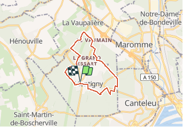
Tocht Stappen van 11,1 km beschikbaar op Normandië, Seine-Maritime, Montigny. Deze tocht wordt voorgesteld door JMCMoreau.
Beschrijving
Boucle de 11Km autour de Montigny. Balade essentiellement en forêt. Beaucoup de sentiers et routes forestières peu de bitume. A faire en famille ou marcheurs sur la 1/2 journée à proximité de Rouen.
Plaatsbepaling
Land:
France
Regio :
Normandië
Departement/Provincie :
Seine-Maritime
Gemeente :
Montigny
Locatie:
Unknown
Vertrek:(Dec)
Vertrek:(UTM)
354684 ; 5480549 (31U) N.
Opmerkingen
Wandeltochten in de omgeving
![Tocht Stappen Saint-Martin-de-Boscherville - Les Marais - St Martin de Boscherville - Photo](https://media.geolcdn.com/t/375/260/ext.jpg?maxdim=2&url=https%3A%2F%2Fservices.sitytrail.com%2FGeolivesWS%2FDownloadMedia.ashx%3FTrailID%3D105880%26Media%3D9864_1.jpg)
![Stappen Stappen](https://static1.geolcdn.com/sitytour/trail-icons/101.png)
Les Marais - St Martin de Boscherville
Stappen
Medium
(1)
Saint-Martin-de-Boscherville,
Normandië,
Seine-Maritime,
France
![](/images/other/stat-length.png)
11,5 km | 13,8 km-effort
2h 30min
![](https://static1.geolcdn.com/siteimages/upload/files/16400158638029165_repeat_loop_refresh_sync_direction_icon.png)
Ja
![Tocht Stappen Canteleu - Canteleu - Montigny - GD - Photo](https://media.geolcdn.com/t/375/260/ext.jpg?maxdim=2&url=https%3A%2F%2Fstatic1.geolcdn.com%2Fsiteimages%2Fupload%2Ffiles%2F1553511878bg_sport_marche.png)
![Stappen Stappen](https://static1.geolcdn.com/sitytour/trail-icons/101.png)
Canteleu - Montigny - GD
Stappen
Moeilijk
(1)
Canteleu,
Normandië,
Seine-Maritime,
France
![](/images/other/stat-length.png)
11,4 km | 13,3 km-effort
3h 0min
![](https://static1.geolcdn.com/siteimages/upload/files/16400158638029165_repeat_loop_refresh_sync_direction_icon.png)
Ja
![Tocht sport Hénouville - 2019-11-25_13h58m16_Cirkwi-Le_tour_d_Hénouville - Photo](https://media.geolcdn.com/t/375/260/ext.jpg?maxdim=2&url=https%3A%2F%2Fsecurestorage.geolives.com%2Fsitytour%2Ftrail-bg%2Fdefault.jpg)
2019-11-25_13h58m16_Cirkwi-Le_tour_d_Hénouville
sport
Heel gemakkelijk
(1)
Hénouville,
Normandië,
Seine-Maritime,
France
![](/images/other/stat-length.png)
10,1 km | 11,3 km-effort
Onbekend
![](https://static1.geolcdn.com/siteimages/upload/files/16400158638029165_repeat_loop_refresh_sync_direction_icon.png)
Ja
![Tocht Stappen Bardouville - bardouville - Photo](https://media.geolcdn.com/t/375/260/ext.jpg?maxdim=2&url=https%3A%2F%2Fstatic1.geolcdn.com%2Fsiteimages%2Fupload%2Ffiles%2F1553511878bg_sport_marche.png)
![Stappen Stappen](https://static1.geolcdn.com/sitytour/trail-icons/101.png)
bardouville
Stappen
Heel gemakkelijk
(1)
Bardouville,
Normandië,
Seine-Maritime,
France
![](/images/other/stat-length.png)
6,1 km | 6,9 km-effort
1h 31min
![](https://static1.geolcdn.com/siteimages/upload/files/16400158638029165_repeat_loop_refresh_sync_direction_icon.png)
Ja
![Tocht Mountainbike Canteleu - Randonnée VTT Oxibike 2011 Canteleu 40 Kms - Photo](https://media.geolcdn.com/t/375/260/ext.jpg?maxdim=2&url=https%3A%2F%2Fstatic1.geolcdn.com%2Fsiteimages%2Fupload%2Ffiles%2F1524743154velo.jpg)
![Mountainbike Mountainbike](https://static1.geolcdn.com/sitytour/trail-icons/202.png)
Randonnée VTT Oxibike 2011 Canteleu 40 Kms
Mountainbike
Moeilijk
(1)
Canteleu,
Normandië,
Seine-Maritime,
France
![](/images/other/stat-length.png)
40 km | 49 km-effort
3h 0min
![](https://static1.geolcdn.com/siteimages/upload/files/16400158638029165_repeat_loop_refresh_sync_direction_icon.png)
Ja
![Tocht Stappen Canteleu - Canteleu forêt monumentale - Photo](https://media.geolcdn.com/t/375/260/ext.jpg?maxdim=2&url=https%3A%2F%2Fstatic1.geolcdn.com%2Fsiteimages%2Fupload%2Ffiles%2F1553511878bg_sport_marche.png)
![Stappen Stappen](https://static1.geolcdn.com/sitytour/trail-icons/101.png)
Canteleu forêt monumentale
Stappen
Medium
(1)
Canteleu,
Normandië,
Seine-Maritime,
France
![](/images/other/stat-length.png)
10 km | 11,4 km-effort
2h 35min
![](https://static1.geolcdn.com/siteimages/upload/files/16400158638029165_repeat_loop_refresh_sync_direction_icon.png)
Ja
![Tocht Stappen Saint-Pierre-de-Varengeville - 20240229-St Pierre de Varengeville - Photo](https://media.geolcdn.com/t/375/260/7008d225-ca6d-481f-b5f8-66a30a344d21.jpg&format=jpg&maxdim=2)
![Stappen Stappen](https://static1.geolcdn.com/sitytour/trail-icons/101.png)
20240229-St Pierre de Varengeville
Stappen
Medium
Saint-Pierre-de-Varengeville,
Normandië,
Seine-Maritime,
France
![](/images/other/stat-length.png)
12,5 km | 15 km-effort
3h 6min
![](https://static1.geolcdn.com/siteimages/upload/files/16400158638029165_repeat_loop_refresh_sync_direction_icon.png)
Ja
![Stappen Stappen](https://static1.geolcdn.com/sitytour/trail-icons/101.png)
20240125-Hénouville
Stappen
Medium
Hénouville,
Normandië,
Seine-Maritime,
France
![](/images/other/stat-length.png)
10 km | 11,3 km-effort
2h 29min
![](https://static1.geolcdn.com/siteimages/upload/files/16400158638029165_repeat_loop_refresh_sync_direction_icon.png)
Ja
![Stappen Stappen](https://static1.geolcdn.com/sitytour/trail-icons/101.png)
20230829-Déville les Rouen
Stappen
Medium
Déville-lès-Rouen,
Normandië,
Seine-Maritime,
France
![](/images/other/stat-length.png)
11,9 km | 16,3 km-effort
3h 38min
![](https://static1.geolcdn.com/siteimages/upload/files/16400158638029165_repeat_loop_refresh_sync_direction_icon.png)
Ja