![](/images/other/stat-length.png)
![Tocht Stappen Levens - Sommet du Ferion - Photo](https://media.geolcdn.com/t/1900/400/09cf5596-f28b-4700-8a62-40771055dbf6.jpg&format=pjpeg&maxdim=2)
Sommet du Ferion
domi06
Gebruiker
![Lengte](/images/other/stat-length.png)
![Max. hoogte](https://static1.geolcdn.com/siteimages/upload/files/1508320355ic_sort_altitude_max_24dp.png)
![Positief hoogteverschil](https://static1.geolcdn.com/siteimages/upload/files/1508320355ic_sort_den_pos_24dp.png)
![Km-Effort](/images/other/stat-length.png)
![Min. hoogte](https://static1.geolcdn.com/siteimages/upload/files/1508320355ic_sort_altitude_min_24dp.png)
![Negatief hoogteverschil](https://static1.geolcdn.com/siteimages/upload/files/1508320355ic_sort_den_neg_24dp.png)
![Boucle](https://static1.geolcdn.com/siteimages/upload/files/16400158638029165_repeat_loop_refresh_sync_direction_icon.png)
![Stappen](https://static1.geolcdn.com/sitytour/trail-icons/101.png)
5h00
Moeilijkheid : Medium
![Scan deze QR-code om de tocht te openen in de SityTrail-applicatie](https://capi.geolives.com/qq0zvz2zws4bq2lad0pu/sitytour/trails/2404281/qr.png?size=200)
Gratisgps-wandelapplicatie
Over ons
Tocht Stappen van 11 km beschikbaar op Provence-Alpes-Côte d'Azur, Alpes-Maritimes, Levens. Deze tocht wordt voorgesteld door domi06.
Beschrijving
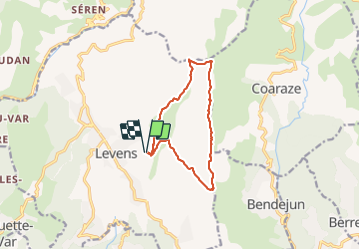
Du parking des Mulières (670 m - b.264), suivre vers l’Est la large draille qui se divise bientôt entre les itinéraires du col du Dragon (Nord) et du col de Travail (Est). Prendre à gauche le premier nommé qui remonte à flanc de la Colle de Millian, au-dessus du ruisseau du Péloubié ; on remarquera sur la rive opposée les campagnes entretenues de Sarse Subrane et Sutrane.
Après une bifurcation de 4 itinéraires (921 m) 2km, poursuivre vers le Nord en direction de la Balma de Caïsson où l’on croise la piste forestière “Delaballe”. Suivre celle-ci jusqu’au col du Dragon (1 111 m - b.272- 3,4km), puis gravir à droite (Est) le sentier raide qui culmine à la crête du Férion au niveau d’un lacet de la piste (1 380 m)- 4,1km
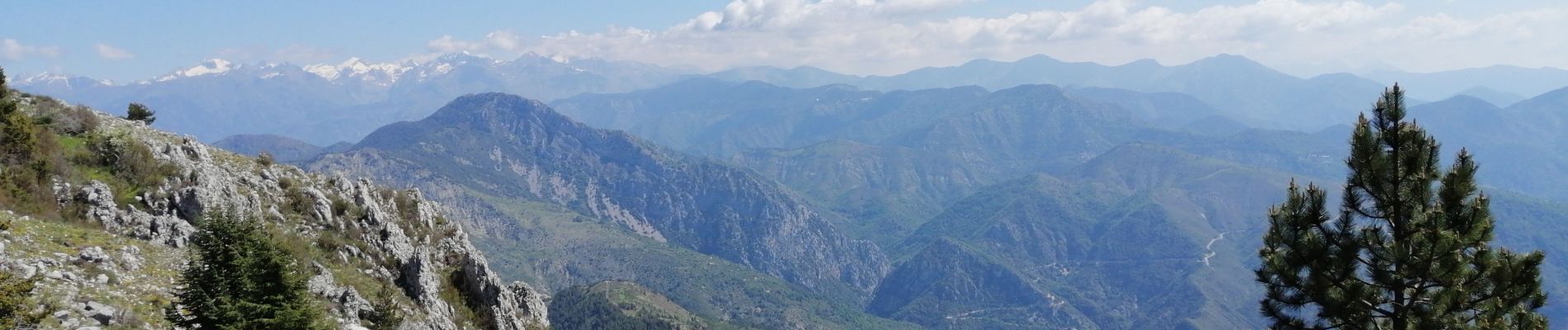
Gagner rapidement la cime du Férion et le poste de guet (1 412 m-4,5km) par le sentier qui chemine au-dessus de la piste dans une forêt de grands pins. Amorcer la descente plein Sud sur l’immense crête du Férion ; une trace un peu timide fait place à un chemin plus large à l’approche de la chapelle Saint-Michel-des-Cèdres (1 261 m-5,5km), construite en 1938.
Continuer toujours plein Sud sur la ligne de crête et rejoindre plus bas la baisse de Bendéjun (916 m - b.279- 8km) ; bifurquer alors à droite pour gagner par une descente régulière le col de Travail (760 m - b.281-9,4km) et le point de départ.
Cotation IBP83 E4/T2/R2
Plaatsbepaling
Opmerkingen
Wandeltochten in de omgeving
![Tocht Stappen Utelle - Le Chaudan Madone Utelle réel - Photo](https://media.geolcdn.com/t/375/260/a8253f62-eac0-40e2-8956-546eb9ade295.jpg&format=jpg&maxdim=2)
![Stappen Stappen](https://static1.geolcdn.com/sitytour/trail-icons/101.png)
Stappen
![](/images/other/stat-length.png)
![](https://static1.geolcdn.com/siteimages/upload/files/16400158638029165_repeat_loop_refresh_sync_direction_icon.png)
![Tocht Te voet Coaraze - Rocca Sparvièra - Photo](https://media.geolcdn.com/t/375/260/b70c2ec2-277e-4b66-a927-a7ae11b9ea3a.jpeg&format=jpg&maxdim=2)
![Te voet Te voet](https://static1.geolcdn.com/sitytour/trail-icons/100.png)
Te voet
![](/images/other/stat-length.png)
![](https://static1.geolcdn.com/siteimages/upload/files/16400158638029165_repeat_loop_refresh_sync_direction_icon.png)
![Tocht Te voet Utelle - Gorges de la Vésubie - Photo](https://media.geolcdn.com/t/375/260/0a667b03-3170-487d-a7f5-45b846bd9fdf.jpeg&format=jpg&maxdim=2)
![Te voet Te voet](https://static1.geolcdn.com/sitytour/trail-icons/100.png)
Te voet
![](/images/other/stat-length.png)
![](https://static1.geolcdn.com/siteimages/upload/files/16400158638029165_repeat_loop_refresh_sync_direction_icon.png)
![Tocht Te voet Utelle - Madone d'Utelle - Photo](https://media.geolcdn.com/t/375/260/186d666d-a9cf-4d78-b5ea-394e8ee2a1a9.jpeg&format=jpg&maxdim=2)
![Te voet Te voet](https://static1.geolcdn.com/sitytour/trail-icons/100.png)
Te voet
![](/images/other/stat-length.png)
![](https://static1.geolcdn.com/siteimages/upload/files/16400158638029165_repeat_loop_refresh_sync_direction_icon.png)
![Tocht Stappen Duranus - Rocca Sparviera Rocca Siera - Photo](https://media.geolcdn.com/t/375/260/cfa7ac61-c812-43a1-a04c-577e01c4a8ee.jpg&format=jpg&maxdim=2)
![Stappen Stappen](https://static1.geolcdn.com/sitytour/trail-icons/101.png)
Stappen
![](/images/other/stat-length.png)
![](https://static1.geolcdn.com/siteimages/upload/files/16400158638029165_repeat_loop_refresh_sync_direction_icon.png)
![Tocht Stappen Coaraze - Rocca Spavierra - Photo](https://media.geolcdn.com/t/375/260/ext.jpg?maxdim=2&url=https%3A%2F%2Fstatic1.geolcdn.com%2Fsiteimages%2Fupload%2Ffiles%2F1553511878bg_sport_marche.png)
![Stappen Stappen](https://static1.geolcdn.com/sitytour/trail-icons/101.png)
Stappen
![](/images/other/stat-length.png)
![](https://static1.geolcdn.com/siteimages/upload/files/16400158638029165_repeat_loop_refresh_sync_direction_icon.png)
![Tocht Stappen Levens - Hike 2017 jour 1 - Photo](https://media.geolcdn.com/t/375/260/ext.jpg?maxdim=2&url=https%3A%2F%2Fstatic1.geolcdn.com%2Fsiteimages%2Fupload%2Ffiles%2F1553511878bg_sport_marche.png)
![Stappen Stappen](https://static1.geolcdn.com/sitytour/trail-icons/101.png)
Stappen
![](/images/other/stat-length.png)
![](https://static1.geolcdn.com/siteimages/upload/files/16400158638029165_repeat_loop_refresh_sync_direction_icon.png)
![Tocht Stappen Bonson - Plan du Var-Tourrette du Château - Photo](https://media.geolcdn.com/t/375/260/b4642ae4-5db0-433c-a2e5-2905ecab06e6.jpg&format=jpg&maxdim=2)
![Stappen Stappen](https://static1.geolcdn.com/sitytour/trail-icons/101.png)
Stappen
![](/images/other/stat-length.png)
![](https://static1.geolcdn.com/siteimages/upload/files/16400158638029165_repeat_loop_refresh_sync_direction_icon.png)
![Tocht Stappen Utelle - Cros d Utelle chapelle St Antoine - Photo](https://media.geolcdn.com/t/375/260/ccd5b578-c9f1-437b-9e91-d8a2d45b6420.jpg&format=jpg&maxdim=2)
![Stappen Stappen](https://static1.geolcdn.com/sitytour/trail-icons/101.png)
Stappen
![](/images/other/stat-length.png)
![](https://static1.geolcdn.com/siteimages/upload/files/16400158638029165_repeat_loop_refresh_sync_direction_icon.png)