![](/images/other/stat-length.png)
![Tocht Stappen Osenbach - JD 17/20 Famille Osenbach Wintzfelden Vallée Noble VCourte - Photo](https://media.geolcdn.com/t/1900/400/ext.pjpeg?maxdim=2&url=https%3A%2F%2Fstatic1.geolcdn.com%2Fsiteimages%2Fupload%2Ffiles%2F1553511878bg_sport_marche.png)
JD 17/20 Famille Osenbach Wintzfelden Vallée Noble VCourte
argonneuweg
Gebruiker
![Lengte](/images/other/stat-length.png)
Lengte
6,3 km
![Max. hoogte](https://static1.geolcdn.com/siteimages/upload/files/1508320355ic_sort_altitude_max_24dp.png)
Max. hoogte
442 m
![Positief hoogteverschil](https://static1.geolcdn.com/siteimages/upload/files/1508320355ic_sort_den_pos_24dp.png)
Positief hoogteverschil
171 m
![Km-Effort](/images/other/stat-length.png)
Km-Effort
8,6 km
![Min. hoogte](https://static1.geolcdn.com/siteimages/upload/files/1508320355ic_sort_altitude_min_24dp.png)
Min. hoogte
318 m
![Negatief hoogteverschil](https://static1.geolcdn.com/siteimages/upload/files/1508320355ic_sort_den_neg_24dp.png)
Negatief hoogteverschil
169 m
![Boucle](https://static1.geolcdn.com/siteimages/upload/files/16400158638029165_repeat_loop_refresh_sync_direction_icon.png)
Boucle
Ja
Datum van aanmaak :
2020-05-17 09:04:00.0
Laatste wijziging :
2020-05-19 12:47:24.149
![Stappen](https://static1.geolcdn.com/sitytour/trail-icons/101.png)
3h06
Moeilijkheid : Medium
![Scan deze QR-code om de tocht te openen in de SityTrail-applicatie](https://capi.geolives.com/qq0zvz2zws4bq2lad0pu/sitytour/trails/2399436/qr.png?size=200)
Gratisgps-wandelapplicatie
Over ons
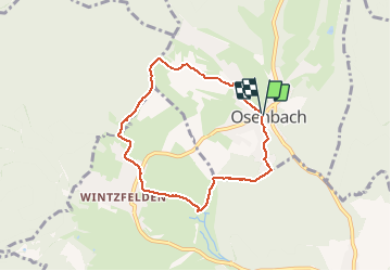
Tocht Stappen van 6,3 km beschikbaar op Grand Est, Haut-Rhin, Osenbach. Deze tocht wordt voorgesteld door argonneuweg.
Beschrijving
Belle promenade familiale, facile, alternant chemins ouverts et ombragés, dans les très jolis paysages de la vallée noble. Si besoin, choisir le site de la maison forestière au nord de Wintzfelden pour pique-niquer.
Plaatsbepaling
Land:
France
Regio :
Grand Est
Departement/Provincie :
Haut-Rhin
Gemeente :
Osenbach
Locatie:
Unknown
Vertrek:(Dec)
Vertrek:(UTM)
367049 ; 5316228 (32T) N.
Opmerkingen
Wandeltochten in de omgeving
![Tocht Stappen Westhalten - 2021 03 04 Westhalten - Photo](https://media.geolcdn.com/t/375/260/227de508-d68e-430e-b1c3-67de94c52b45.jpg&format=jpg&maxdim=2)
![Stappen Stappen](https://static1.geolcdn.com/sitytour/trail-icons/101.png)
2021 03 04 Westhalten
Stappen
Gemakkelijk
(1)
Westhalten,
Grand Est,
Haut-Rhin,
France
![](/images/other/stat-length.png)
7,7 km | 11,3 km-effort
2h 21min
![](https://static1.geolcdn.com/siteimages/upload/files/16400158638029165_repeat_loop_refresh_sync_direction_icon.png)
Ja
![Stappen Stappen](https://static1.geolcdn.com/sitytour/trail-icons/101.png)
Osenbach - Sentier des Sols
Stappen
Gemakkelijk
(1)
Osenbach,
Grand Est,
Haut-Rhin,
France
![](/images/other/stat-length.png)
4,7 km | 6,6 km-effort
3h 0min
![](https://static1.geolcdn.com/siteimages/upload/files/16400158638029165_repeat_loop_refresh_sync_direction_icon.png)
Ja
![Tocht Stappen Rouffach - suuntoapp-Hiking-2023-10-22T08-43-15Z - Photo](https://media.geolcdn.com/t/375/260/0163933f-fc15-4bbf-b5e2-ea81260dd156.jpg&format=jpg&maxdim=2)
![Stappen Stappen](https://static1.geolcdn.com/sitytour/trail-icons/101.png)
suuntoapp-Hiking-2023-10-22T08-43-15Z
Stappen
Medium
Rouffach,
Grand Est,
Haut-Rhin,
France
![](/images/other/stat-length.png)
19 km | 33 km-effort
7h 34min
![](https://static1.geolcdn.com/siteimages/upload/files/16400158638029165_repeat_loop_refresh_sync_direction_icon.png)
Ja
![Tocht Stappen Westhalten - ND du Hubel_Schauenberg - Photo](https://media.geolcdn.com/t/375/260/ext.jpg?maxdim=2&url=https%3A%2F%2Fstatic1.geolcdn.com%2Fsiteimages%2Fupload%2Ffiles%2F1553511878bg_sport_marche.png)
![Stappen Stappen](https://static1.geolcdn.com/sitytour/trail-icons/101.png)
ND du Hubel_Schauenberg
Stappen
Medium
(2)
Westhalten,
Grand Est,
Haut-Rhin,
France
![](/images/other/stat-length.png)
8,3 km | 11,7 km-effort
2h 39min
![](https://static1.geolcdn.com/siteimages/upload/files/16400158638029165_repeat_loop_refresh_sync_direction_icon.png)
Ja
![Tocht Stappen Wasserbourg - Autour de Wasserbourg - Photo](https://media.geolcdn.com/t/375/260/ext.jpg?maxdim=2&url=https%3A%2F%2Fstatic1.geolcdn.com%2Fsiteimages%2Fupload%2Ffiles%2F1553511878bg_sport_marche.png)
![Stappen Stappen](https://static1.geolcdn.com/sitytour/trail-icons/101.png)
Autour de Wasserbourg
Stappen
Gemakkelijk
(1)
Wasserbourg,
Grand Est,
Haut-Rhin,
France
![](/images/other/stat-length.png)
8,8 km | 14 km-effort
2h 6min
![](https://static1.geolcdn.com/siteimages/upload/files/16400158638029165_repeat_loop_refresh_sync_direction_icon.png)
Ja
![Tocht Mountainbike Westhalten - Westhalten - Le tour de la vallée Noble - Photo](https://media.geolcdn.com/t/375/260/ext.jpg?maxdim=2&url=https%3A%2F%2Fstatic1.geolcdn.com%2Fsiteimages%2Fupload%2Ffiles%2F1524743154velo.jpg)
![Mountainbike Mountainbike](https://static1.geolcdn.com/sitytour/trail-icons/202.png)
Westhalten - Le tour de la vallée Noble
Mountainbike
Moeilijk
(1)
Westhalten,
Grand Est,
Haut-Rhin,
France
![](/images/other/stat-length.png)
24 km | 33 km-effort
2h 30min
![](https://static1.geolcdn.com/siteimages/upload/files/16400158638029165_repeat_loop_refresh_sync_direction_icon.png)
Ja
![Tocht Stappen Pfaffenheim - Marche TL 10/2024 - Parking Chataignier- ND du Schauenburg-Rocher du Coucou-Carrières de Gueberschwihr-Sentier de découvertes- Taverne médiévale-Chapelle St Léonard et retour - Photo](https://media.geolcdn.com/t/375/260/ext.jpg?maxdim=2&url=https%3A%2F%2Fstatic1.geolcdn.com%2Fsiteimages%2Fupload%2Ffiles%2F1553511878bg_sport_marche.png)
![Stappen Stappen](https://static1.geolcdn.com/sitytour/trail-icons/101.png)
Marche TL 10/2024 - Parking Chataignier- ND du Schauenburg-Rocher du Coucou-C...
Stappen
Moeilijk
(1)
Pfaffenheim,
Grand Est,
Haut-Rhin,
France
![](/images/other/stat-length.png)
8,5 km | 12,5 km-effort
2h 50min
![](https://static1.geolcdn.com/siteimages/upload/files/16400158638029165_repeat_loop_refresh_sync_direction_icon.png)
Ja
![Tocht Stappen Gueberschwihr - Gueberschwihr - Voegtlinshoffen - N.-D. de Schauenberg - Pfaffenheim - Photo](https://media.geolcdn.com/t/375/260/57a4399f-f031-43d5-815d-2890d8fbc622.jpg&format=jpg&maxdim=2)
![Stappen Stappen](https://static1.geolcdn.com/sitytour/trail-icons/101.png)
Gueberschwihr - Voegtlinshoffen - N.-D. de Schauenberg - Pfaffenheim
Stappen
Moeilijk
Gueberschwihr,
Grand Est,
Haut-Rhin,
France
![](/images/other/stat-length.png)
13,1 km | 18,9 km-effort
4h 17min
![](https://static1.geolcdn.com/siteimages/upload/files/16400158638029165_repeat_loop_refresh_sync_direction_icon.png)
Ja
![Tocht Stappen Westhalten - WESTHALTEN ZINKOEPHLE - Photo](https://media.geolcdn.com/t/375/260/bb43cbf9-190d-4da9-9235-1bfdec11bc91.jpg&format=jpg&maxdim=2)
![Stappen Stappen](https://static1.geolcdn.com/sitytour/trail-icons/101.png)
WESTHALTEN ZINKOEPHLE
Stappen
Medium
Westhalten,
Grand Est,
Haut-Rhin,
France
![](/images/other/stat-length.png)
10,6 km | 15,3 km-effort
2h 56min
![](https://static1.geolcdn.com/siteimages/upload/files/16400158638029165_repeat_loop_refresh_sync_direction_icon.png)
Ja