Tocht Mountainbike Wacquemoulin - Le chemin des Chars - Photo

Le chemin des Chars

 azerty.69696
azerty.69696

Gebruiker

© OpenStreetMap contributors
Lengte
Lengte
79 km
Max. hoogte
Max. hoogte
145 m
Positief hoogteverschil
880 m
Km-Effort
Km-Effort  
91 km
Min. hoogte
Min. hoogte
56 m
Negatief hoogteverschil
881 m
Boucle
Boucle
Neen
Datum van aanmaak :
2014-12-10 00:00:00.0
Laatste wijziging :
2014-12-10 00:00:00.0

(1 Bericht)

Mountainbike
Mountainbike
7h00
Moeilijkheid : Medium

Scan deze QR-code om de tocht te openen in de SityTrail-applicatie

Gratisgps-wandelapplicatie

Logo SityTrail SityTrail

IGN / Geografische instituten

SityTrail uit de App Store downloaden SityTrail uit Google Play downloaden

Logo SityTrail SityTrail World

De wereld gaat voor u open

SityTrail uit de App Store downloaden SityTrail uit Google Play downloaden SityTrail op Huawei AppGallery downloaden

Over ons

Tocht Mountainbike van 79 km beschikbaar op Hauts-de-France, Oise, Wacquemoulin. Deze tocht wordt voorgesteld door azerty.69696.

Beschrijving

Sortie VTT sur le chemin de la mémoire des chars.Départ de Wacquemoulin, 81 km de pistes et de routes de campagne en 7 heures.Très bon balisage, juste une balise invisible en sortant du bois de Montgérain.infos surhttp://www.oise-randonnee.com/A-velo/Itineraires-a-velo/Circuits-VTT-VTC/(offre)/RANDOPIC06000043

Hoogteprofiel

POI's

POI Courcelles-Epayelles - [EVT60] Courcelles Epayelles - Circuit des Chars. - Photo
azerty.69696
COURCELLES-EPAYELLES 
POI Wacquemoulin - [EVT60] Wacquemoulin - La Gare. - Photo
azerty.69696
POI Ménévillers - [EVT60] Menevillers - la Place du Village. - Photo
azerty.69696
POI Ménévillers - IMG_00011 - Photo
azerty.69696
MÉNÉVILLERS 
POI Ménévillers - IMG_00021 - Photo
azerty.69696
MÉNÉVILLERS 
POI Maignelay-Montigny - IMG_00041 - Photo
azerty.69696
MAIGNELAY-MONTIGNY 
POI Coivrel - IMG_00051 - Photo
azerty.69696
COIVREL 
POI Courcelles-Epayelles - IMG_00061 - Photo
azerty.69696
COURCELLES-EPAYELLES 
POI Lataule - IMG_00071 - Photo
azerty.69696
LATAULE 
POI Gournay-sur-Aronde - IMG_00081 - Photo
azerty.69696
GOURNAY-SUR-ARONDE 
POI Gournay-sur-Aronde - IMG_00091 - Photo
azerty.69696
GOURNAY-SUR-ARONDE 
POI Méry-la-Bataille - IMG_00101 - Photo
azerty.69696
MÉRY-LA-BATAILLE 

Plaatsbepaling

Land:
France
Regio :
Hauts-de-France
Departement/Provincie :
Oise
Gemeente :
Wacquemoulin
Locatie:
Unknown
Vertrek:(Dec)
Vertrek:(UTM)
471885 ; 5483437 (31U) N.

Opmerkingen

Gelieve in te loggen om een commentaar of een beoordeling achter te laten


très bien


Wandeltochten in de omgeving

Tocht Stappen Saint-Martin-aux-Bois - La vallée rouge à St Martin aux bois - Photo
Stappen
José800

Stappen

Medium
Saint-Martin-aux-Bois, Hauts-de-France, Oise, France
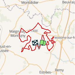
14,4 km | 16,7 km-effort
3h 26min
Ja
Tocht Paard Gournay-sur-Aronde - Gournay sur Aronde - Circuit de la Somme d'Or - Photo
Paard
tracegps

Paard

Medium
Gournay-sur-Aronde, Hauts-de-France, Oise, France
5,7 km | 6,9 km-effort
1h 0min
Ja
Tocht Mountainbike Gournay-sur-Aronde - Gournay sur Aronde - Circuit de la Somme d'Or - Photo
Mountainbike
tracegps

Mountainbike

Gemakkelijk
Gournay-sur-Aronde, Hauts-de-France, Oise, France
5,7 km | 6,9 km-effort
30min
Ja
Tocht Stappen Gournay-sur-Aronde - Gournay sur Aronde - Circuit de la Somme d'Or - Photo
Stappen
tracegps

Stappen

Gemakkelijk
Gournay-sur-Aronde, Hauts-de-France, Oise, France
5,7 km | 6,9 km-effort
1h 19min
Ja
Tocht Stappen Cressonsacq - 210603  - Photo
Stappen
fab1761

Stappen

Heel gemakkelijk
Cressonsacq, Hauts-de-France, Oise, France
3,4 km | 3,6 km-effort
45min
Ja
Tocht Mountainbike Cressonsacq - 200829 - Photo
Mountainbike
fab1761

Mountainbike

Gemakkelijk
Cressonsacq, Hauts-de-France, Oise, France
7,8 km | 8,7 km-effort
34min
Ja
Tocht Stappen Cressonsacq - 13- Le chemin des châteaux - Photo
Stappen
fitz2014

Stappen

Gemakkelijk
Cressonsacq, Hauts-de-France, Oise, France
10,4 km | 11,7 km-effort
2h 16min
Ja
Tocht Te voet Saint-Martin-aux-Bois - Le chemin de la vallée rouge  - Photo
Te voet
José800

Te voet

Gemakkelijk
Saint-Martin-aux-Bois, Hauts-de-France, Oise, France
11,6 km | 13,8 km-effort
3h 7min
Ja
Tocht Te voet Saint-Martin-aux-Bois - Le chemin de laVallée rouge - Photo
Te voet
José800

Te voet

Gemakkelijk
Saint-Martin-aux-Bois, Hauts-de-France, Oise, France
9,5 km | 11,2 km-effort
2h 32min
Ja


Sluiten
Mijn abonnementen